
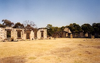
The Tasman Peninsula, officially Turrakana / Tasman Peninsula, is a peninsula located in south-east Tasmania, Australia, approximately 75 km (47 mi) by the Arthur Highway, south-east of Hobart.

Latrobe is a town in northern Tasmania, Australia on the Mersey River. It is 8 km south-east of Devonport on the Bass Highway. It is the main centre of the Latrobe Council. At the 2006 census, Latrobe had a population of 2,843. By the 2016 census, this had increased to 4,169. The locality is in the Latrobe Council area, but with a mere 0.1% in the Kentish Council LGA.

Tasman Council is a local government body in Tasmania, situated in the south-east of the state. Tasman is classified as a rural local government area and has a population of 2,404, the region covers both the Tasman and Forestier peninsulas, with Nubeena the principal town.

Sorell is a town in Tasmania, Australia, north-east of Hobart. It is located on the Tasman Highway at the junction with the Arthur Highway. Sorell is one of Tasmania's oldest towns, being first settled in 1808 as a small farming community and becoming an official township in 1821. At the 2006 census, Sorell had a population of 1,546, and at the 2011 census, a population of 2,476. and at the 2016 census, a population of 2,907.

George Town is a large town in north-east Tasmania, on the eastern bank of the mouth of the Tamar River. The Australian Bureau of Statistics records the George Town Municipal Area had a population of 6,764 as of 30 June 2016.

HuonvilleHYOO-on-vil is a town on the Huon River, in the south-east of Tasmania, Australia. It is the seat of the Huon Valley Council area and lies 38 km south of Hobart on the Huon Highway. At the 2016 census, Huonville had a population of 2,714 and at the 2011 census had a population of 1,741.
Scottsdale, formerly known as Ellesmere, is a town in the north-east of Tasmania, Australia. It lies on the Tasman Highway, around 63 kilometres (39 mi) north-east of Launceston and 22 km (14 mi) south-east of the coastal town of Bridport. It is part of the Dorset Council.

Ulverstone is a town on the northern coast of Tasmania, Australia on the mouth of the River Leven, on Bass Strait. It is on the Bass Highway, 21 kilometres (13 mi) west of Devonport and 12 kilometres (7 mi) east of Penguin.
Westbury is a town in the central north of Tasmania, Australia. It lies 30 km west of Launceston on the Bass Highway, and at the 2021 census had a population of 2,272. It is part of, and the headquarters of, the Meander Valley Council area.
Saltwater River is a rural locality in the local government area (LGA) of Tasman in the South-east LGA region of Tasmania. The locality is about 14 kilometres (8.7 mi) north of the town of Nubeena. The 2016 census has a population of 123 for the state suburb of Saltwater River.
The Arthur Highway (A9) is a Tasmanian highway which runs from Sorell in the near south to Port Arthur in the far south-east.

Kadina is a town on the Yorke Peninsula of the Australian state of South Australia, approximately 144 kilometres north-northwest of the state capital of Adelaide. The largest town of the Peninsula, Kadina is one of the three Copper Triangle towns famous for their shared copper mining history. The three towns are known as "Little Cornwall" for the significant number of immigrants from Cornwall who worked at the mines in the late 19th century.

Hamilton is a rural locality in the local government area (LGA) of Central Highlands in the Central LGA region of Tasmania. The locality is about 73 kilometres (45 mi) north-west of the city of Hobart. The 2016 census recorded a population of 241 for the suburb of Hamilton.

Jervis Bay Village is a village in the Jervis Bay Territory, Australia. HMAS Creswell Royal Australian Navy base is located in the town. Apart from the navy base there is an Aboriginal community in the town. It is the largest town in the Jervis Bay Territory, with 189 inhabitants.
Eaglehawk Neck, officially Teralina / Eaglehawk Neck, is a narrow isthmus that connects the Tasman Peninsula with the Forestier Peninsula and hence to the rest of Tasmania, Australia.

Triabunna is a rural residential locality in the local government area (LGA) of Glamorgan–Spring Bay in the South-east LGA region of Tasmania. The locality is about 86 kilometres (53 mi) north-east of the city of Hobart. The 2021 census has a population of 905 for the state suburb of Triabunna.
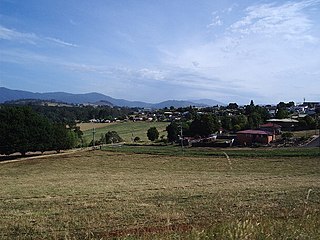
Taranna is a rural locality in the local government area (LGA) of Tasman in the South-east LGA region of Tasmania. The locality is about 16 kilometres (9.9 mi) north-east of the town of Nubeena. The 2016 census recorded a population of 156 for the state suburb of Taranna. It is a hamlet on the Tasman Peninsula. Local points of interest include its Presbyterian church, immediately adjacent to the Federation Chocolate Factory, and a Tasmanian devil park, "Unzoo".
Whitemark is a rural residential locality on Flinders Island in the local government area (LGA) of Flinders in the North-east LGA region of Tasmania. The 2021 census recorded a population of 308 for the state suburb of Whitemark. It is the main settlement of Flinders Island.
Murdunna is a rural locality in the local government area (LGA) of Tasman in the South-east LGA region of Tasmania. The locality is about 36 kilometres (22 mi) north-east of the town of Nubeena. The 2016 census recorded a population of 309 for the state suburb of Murdunna. It is a small town at the head of King George Sound, a narrow bay opening off Norfolk Bay. Murdunna is approximately halfway down the Forestier Peninsula on the Arthur Highway to Port Arthur. It is around 6 metres above sea level.

Liawenee is a small town in Tasmania, Australia built near Great Lake and the River Ouse, and was established on 11 June 1920. The town is an ex-Hydro village and now a residence for Inland Fisheries Services (IFS) and a Tasmania Police station. It is known for its exceptional fishing at nearby Great Lake and hosts several trout fishing events.
