Protected areas of Tasmania consist of protected areas located within Tasmania and its immediate onshore waters, including Macquarie Island. It includes areas of crown land managed by Tasmanian Government agencies as well as private reserves. As of 2016, 52% of Tasmania's land area has some form of reservation classification, the majority is managed by the Tasmania Parks & Wildlife Service. Marine protected areas cover about 7.9% of state waters.
The history of Tasmania begins at the end of the Last Glacial Period when it is believed that the island was joined to the Australian mainland. Little is known of the human history of the island until the British colonisation of Tasmania in the 19th century.

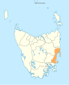
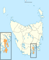
Clarence City Council is a local government body in Tasmania, and one of the five municipalities that constitutes the Greater Hobart Area. The Clarence local government area has a population of 61,531, covering the eastern shore of the Derwent River from Otago to the South Arm Peninsula and the smaller localities of Cambridge, Richmond, and Seven Mile Beach.
Kingborough Council is a local government body in Tasmania, and one of the five municipalities that constitutes the Greater Hobart Area. Kingborough is classified as an urban local government area and has a population of 37,734, it covers the transition from the southern urban areas of Hobart through Kingston, as well as encompassing Bruny Island.

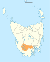
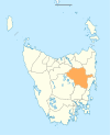
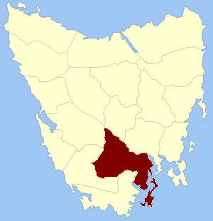
Huon Valley Council is a local government body in Tasmania, covering most of the south of the state. Huon Valley is classified as a rural local government area and has a population of 17,219, towns and localities of the region include Cygnet, Dover, Franklin, Geeveston, Southport and the largest principal town, Huonville.

Derwent Valley Council is a local government body situated in southern-central Tasmania, west of Hobart. Derwent Valley is classified as a rural local government area and has a population of 10,290, it includes the localities of Bushy Park, Maydena and Strathgordon, with New Norfolk the major, principal town.

The Tasman Highway is a highway in Tasmania, Australia. Like the Midland Highway, it connects the major cities of Hobart and Launceston – however it takes a different route, via the north-eastern and eastern coasts of the state. The Highway also acts as a major commuter road to Hobart residents living on the eastern side of the Derwent River. The designation "Tasman Highway" arises from its location facing the Tasman Sea – named, like the state itself, after Abel Tasman. The highway is one of the longest in Tasmania – 410 km (250 mi), with an average travelling time of 41⁄2 hours.

Rail transport in Tasmania consists of a network of narrow gauge track of 1,067 mm reaching virtually all cities and major towns in the island state of Tasmania, Australia. Today, rail services are focused primarily on bulk freight, with no commercial passenger services being operated. The mainline railways of Tasmania are currently operated by TasRail, a Government of Tasmania-owned Corporation, who owns and maintains both rolling stock, locomotives, and track infrastructure.
Glenlusk is a rural locality in the local government areas (LGA) of Derwent Valley (6%) and Glenorchy (94%) in the South-east and Hobart LGA regions of Tasmania. The locality is about 8 kilometres (5.0 mi) west of the town of Glenorchy. The 2016 census recorded a population of 200 for the state suburb of Glenlusk. It is a semi-rural suburb of Hobart. It is west of Chigwell.

Metro Tasmania, commonly called Metro, a Tasmanian Government business enterprise, is the largest bus operator in the state of Tasmania, Australia, with operations in three of the four largest urban centres of Hobart, Launceston, and Burnie. Urban services in Devonport are provided by a private operator, Kinetic. Services are provided by Metro under a range of urban and non-urban contracts with the Transport Commission, a division within the Department of State Growth.

Burnie City Council is a local government body in Tasmania, located in the city and surrounds of Burnie in the north-west of the state. The Burnie local government area is classified as urban and has a population of 19,348, which also encompasses Cooee, Hampshire, Natone and Ridgley.
Buckingham Land District is one of the twenty land districts of Tasmania which are part of the Lands administrative divisions of Tasmania. It was formerly Buckingham County, one of the 18 counties of Tasmania and one of the first eleven proclaimed in 1836 and is bordered to the north by the River Derwent, and to the south by the Huon River. It includes Bruny Island. Hobart is located in the county. It was named after the then county of England.
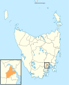
Grove is a rural locality in the local government area (LGA) of Huon Valley in the South-east region of Tasmania, Australia. The locality is 35 km southwest of Hobart and 7 km north-east of the town of Huonville. As a rural locality, there are no urban settlements in Grove. The 2016 census does not provide a population for the locality of Grove. It covers an area of approximately 30.8 km². The postcode for Grove is 7109.
Hobart Coaches was a Tasmanian coach company. It was originally started as a subsidiary company of Hazell Bros with services starting in the Kingston and Blackmans Bay, D'Entrecasteaux Channel, Huon, Richmond and New Norfolk areas.

Bass Strait Ferries have been the ships that have been used for regular transport across Bass Strait between Tasmania and Victoria in mainland Australia, as well as the various attempts to link Tasmania with Sydney. Historically, some regular shipping services in the twentieth century linked Sydney, Melbourne and Hobart with the Bass Strait ports: Launceston's various port locations, Devonport and Burnie. The distinction between coastal shipping and Bass Strait ferry has been blurred at times.

Sandfly is a suburb in the Kingborough Council local government area in Tasmania, Australia. A region of the Franklin Electorate, Sandfly is a historic area that sits between the suburbs of Longley, Lower Longley, Allens Rivulet, Margate, Leslie Vale and Kaoota. The population of Sandfly in 2011 was 156.
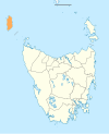
In the Australian state of Tasmania, there are many areas which are commonly known by regional names. Regions are areas that share similar characteristics. These characteristics may be natural such as the Furneaux Islands, the coastline, or the Central Highlands. Alternatively, the characteristics may be cultural, such as a viticulture land use. Tasmania is divided by numerous regional boundaries, based on different characteristics. In many cases boundaries defined by different government agencies are coterminous and are often cited by the Australian and local media that tend to distinguish between North West, West Coast, Southern, and East Coast.
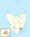
Stowport is a rural residential locality in the local government area (LGA) of Burnie in the North-west and west LGA region of Tasmania. The locality is about 11 kilometres (6.8 mi) south-east of the town of Burnie. The 2016 census has a population of 404 for the state suburb of Stowport. It includes Glance Creek in its population statistics.