
Hobart is the capital and most populous city of the island state of Tasmania, Australia. Home to almost half of all Tasmanians, it is the southernmost and least-populated Australian state capital city, and second-smallest if territories are taken into account, before Darwin, Northern Territory. Hobart is located in Tasmania's south-east on the estuary of the River Derwent, making it the most southern of Australia's capital cities. Its skyline is dominated by the 1,271-metre (4,170 ft) kunanyi/Mount Wellington, and its harbour forms the second-deepest natural port in the world, with much of the city's waterfront consisting of reclaimed land. The metropolitan area is often referred to as Greater Hobart, to differentiate it from the City of Hobart, one of the seven local government areas that cover the city. It has a mild maritime climate.

Clarence City Council is a local government body in Tasmania, and one of the five municipalities that constitutes the Greater Hobart Area. The Clarence local government area has a population of 61,531, covering the eastern shore of the Derwent River from Otago to the South Arm Peninsula and the smaller localities of Cambridge, Richmond, and Seven Mile Beach.

Bellerive Oval is a cricket and Australian rules football ground located in Bellerive, a suburb on the eastern shore of Hobart, Australia, holding 20,000 people it is the largest capacity stadium in Tasmania. It is the only venue in Tasmania which hosts international cricket matches.

The Tasmania men's cricket team, nicknamed the Tigers, represents the Australian state of Tasmania in cricket. They compete annually in the Australian domestic senior men's cricket season, which consists of the first-class Sheffield Shield and the limited overs Matador BBQs One-Day Cup.
Richmond is a town in Tasmania about 25 km north-east of Hobart, in the Coal River region, between the Midland Highway and Tasman Highway. At the 2006 census, Richmond had a population of 880.

Sorell is a town in Tasmania, Australia, north-east of Hobart. It is located on the Tasman Highway at the junction with the Arthur Highway. Sorell is one of Tasmania's oldest towns, being first settled in 1808 as a small farming community and becoming an official township in 1821. At the 2006 census, Sorell had a population of 1,546, and at the 2011 census, a population of 2,476. and at the 2016 census, a population of 2,907.

New Norfolk is a town on the River Derwent, in the south-east of Tasmania, Australia. With a population of 6,153 in 2021, New Norfolk is the principal township of the Derwent Valley region. Located within the Derwent Valley Council, New Norfolk is situated 32 kilometres (20 mi) north-west of the state capital Hobart on the Lyell Highway and classified as part of the Greater Hobart statistical area.

The Tasman Highway is a highway in Tasmania, Australia. Like the Midland Highway, it connects the major cities of Hobart and Launceston – however it takes a different route, via the north-eastern and eastern coasts of the state. The Highway also acts as a major commuter road to Hobart residents living on the eastern side of the Derwent River. The designation "Tasman Highway" arises from its location facing the Tasman Sea – named, like the state itself, after Abel Tasman. The highway is one of the longest in Tasmania – 410 km (250 mi), with an average travelling time of 41⁄2 hours.

Lindisfarne is a suburb of Hobart's Eastern Shore, located approximately 6 kilometres from the City Centre and is part of the municipal City of Clarence.
Montagu Bay is a suburb of Hobart, Tasmania, located in the City of Clarence on the eastern shore of the Derwent River, about four kilometres from the city centre of greater Hobart. It is a small primarily residential suburb located between Rosny, Rose Bay and Lindisfarne and is centred on a small bay of the same name, formerly known as Smelting Works Bay. The bay has a boat ramp and jetty, and is frequently filled with yachts and other vessels at anchor.

Hells Gates is the name of the mouth of Macquarie Harbour on the West Coast of Tasmania, Australia.
Hobart FM is a radio station in Hobart, Australia broadcasting on 96.1 MHz and 92.1 MHz. They do not provide a track list.

North Hobart Oval is a sports venue in North Hobart, Tasmania. Formerly used primarily for Australian rules football widely regarded as the traditional home of Australian football in Tasmania. However since the 1950s it has also become one of the main soccer venues in Tasmania.
The modern history of the Australian city of Hobart in Tasmania dates to its foundation as a British colony in 1804. Prior to British settlement, the area had been occupied definitively for at least 8,000 years, and possibly for as long as 35,000 years, by the semi-nomadic Mouheneener tribe, a sub-group of the Nuenonne, or South-East tribe. The descendants of theses indigenous Tasmanians now refer to themselves as 'Palawa'. Little is known about the region from prehistoric times. As with many other Australia cities, urbanisation has destroyed much of the archaeological evidence of indigenous occupation, although aboriginal middens are often still present in coastal areas.
Rosny Park is a suburb of Hobart, Tasmania, located in the City of Clarence on the eastern shore of the Derwent River. It is about five kilometres from the city centre of Hobart. Rosny Park is the commercial twin of its residential namesake, Rosny.
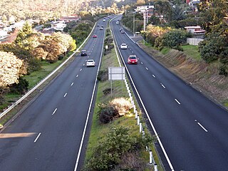
The South Arm Highway is a highway serving the southern suburbs of Hobart, on the eastern shore of the River Derwent in Tasmania, Australia. The highway is a major trunk road that carries heavy commuter traffic south from the Eastern Outlet to Howrah and Rokeby. As one of the Tasman Highway's principle Feeders and one of the eastern shore's major transport corridors, The South Arm Highway facilitates the movement of traffic between the suburbs and satellite communities to the south with the city centre and ultimately, other major cross city highways. With annual average daily traffic (AADT) of 17,000, the highway is considered a major traffic corridor within Hobart. The designation "South Arm Highway" arises from its journey south to South Arm.

The Hobart coastal defences are a network of now defunct coastal batteries, some of which are inter-linked with tunnels, that were designed and built by British colonial authorities in the nineteenth century to protect the city of Hobart, Tasmania, from attack by enemy warships. During the nineteenth century, the port of Hobart Town was a vital re-supply stop for international shipping and trade, and therefore a major freight hub for the British Empire. As such, it was considered vital that the colony be protected. In all, between 1804 and 1942 there were 12 permanent defensive positions constructed in the Hobart region.
James Blackburn was an English civil engineer, surveyor and architect best known for his work in Australia, where he had been transported as a sentence for forgery. According to the Australian Dictionary of Biography, Blackburn "has claims to be considered one of the greatest engineers of his period in Australia, and his architectural achievements established him as Tasmania's most advanced and original architect." He was key to the formation of the Department of Public Works in 1839, serving as one of its core members under Alexander Cheyne.

South Eastern Tasmania Eightball Association is the governing body for the South Eastern Tasmania, Australia or the "Eastern Shore" of Hobart for the sport of Eightball pool, a cue sport and is affiliated with Eightball Tasmania.
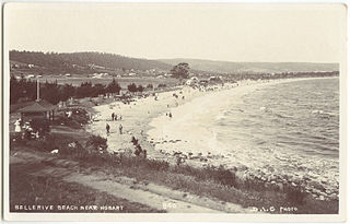
Bellerive Beach is a popular beach destination along the River Derwent in Bellerive, Hobart, Tasmania. The south facing beach neighbours the historic Kangaroo Battery coastal defences to the west and Howrah Beach to the east. The beach has views of the Derwent estuary, Howrah, Tranmere and Sandy Bay on the western shore. Bellerive Beach has an adjoining parkland with play equipment, barbecues and bathroom facilities and is backed by the Bellerive Oval, a narrow tree-lined reserve and private properties.


