
Hobart ( HOH-bart; is the capital and most populous city of the island state of Tasmania, Australia. Located in Tasmania's south-east on the estuary of the River Derwent, it is the southernmost capital city in Australia. Despite containing nearly half of Tasmania's population, Hobart is the least-populated Australian state capital city, and second-smallest by population and area after Darwin if territories are taken into account. Its skyline is dominated by the 1,271-metre kunanyi / Mount Wellington, and its harbour forms the second-deepest natural port in the world, with much of the city's waterfront consisting of reclaimed land. The metropolitan area is often referred to as Greater Hobart, to differentiate it from the City of Hobart, one of the seven local government areas that cover the city. It has a mild maritime climate.

Clarence City Council is a local government body in Tasmania, and one of the five municipalities that constitutes the Greater Hobart Area. The Clarence local government area has a population of 61,531, covering the eastern shore of the Derwent River from Otago to the South Arm Peninsula and the smaller localities of Cambridge, Richmond, and Seven Mile Beach.

Sorell is a town in Tasmania, Australia, north-east of Hobart. It is located on the Tasman Highway at the junction with the Arthur Highway. Sorell is one of Tasmania's oldest towns, being first settled in 1808 as a small farming community and becoming an official township in 1821. At the 2006 census, Sorell had a population of 1,546, and at the 2011 census, a population of 2,476. and at the 2016 census, a population of 2,907.

New Town is a suburb of the city of Hobart, Tasmania, Australia, about 4 kilometres (2 mi) north of the central business district of Hobart. It is generally considered Hobart's oldest suburb, settled just a week after Sullivans Cove. It was historically the home of many of Hobart's wealthiest citizens, and New Town features a large number of grand residences, churches, and public buildings. The large farms were broken up following the world wars and it is now an inner city residential suburb. Many of its streets are lined with Federation style cottages. It is surrounded by the suburbs of North Hobart, Mount Stuart, Lenah Valley and Moonah, with the Queen's Domain just to the south-east. Most of the locality is within the Hobart local government area, with 2.5% within Glenorchy.

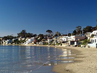
Bellerive is a suburb of the City of Clarence, part of the greater Hobart area, Tasmania, Australia. It stretches from Kangaroo Bay where it borders Rosny Park, around the curved shoreline of Bellerive Esplanade to Kangaroo Bluff, then down to Bellerive Beach and east to Second Bluff, where Bellerive borders Howrah. To the north Bellerive is bordered by the small foothills of Waverly Flora Park.

Montagu Bay is a suburb of Hobart, Tasmania, located in the City of Clarence on the eastern shore of the Derwent River, about four kilometres from the city centre of greater Hobart. It is a small primarily residential suburb located between Rosny, Rose Bay and Lindisfarne and is centred on a small bay of the same name, formerly known as Smelting Works Bay. The bay has a boat ramp and jetty, and is frequently filled with yachts and other vessels at anchor.

South Hobart is one of Hobart's inner suburbs. It is bound by Dynnyrne, Fern Tree, West Hobart and the Hobart City Centre.

Risdon Vale is an outer suburb of Hobart, capital of Tasmania, Australia on the eastern shore of the River Derwent, and adjacent to Risdon Cove, which was the site of the British colonisation of Van Diemen's Land.

Oatlands is an important historical village on the shores of Lake Dulverton in the centre of Tasmania, Australia. Oatlands is located 84 km north of Hobart and 115 km south of Launceston on the Midland Highway. At the 2021 census, Oatlands had a population of 728.
Pontville is a rural locality in the local government areas (LGA) of Brighton and Southern Midlands in the Hobart and Central LGA regions of Tasmania. The locality is about 4 kilometres (2.5 mi) north-west of the town of Brighton. The 2016 census has a population of 623 for the state suburb of Pontville.

Taroona is a major residential suburb approximately 15 minutes drive from the centre of Hobart, Tasmania on the scenic route between Hobart and Kingston. Although on the edges of the City of Hobart, Taroona is actually part of the municipality of Kingborough. Taroona is bounded on the east by the Derwent River, and has several beaches along the shore, the main beaches with public access are Taroona Beach, Hinsby Beach and Dixons Beach. Past Hinsby Beach, the Alum Cliffs form a section of cliffed coast to the neighbouring suburb of Bonnet Hill.
Risdon is a suburb of Hobart, capital city of Tasmania. It is west of Risdon Vale.
South Arm is a rural residential locality in the local government area of Clarence in the Hobart region of Tasmania. The locality is about 32 kilometres (20 mi) south-east of the town of Rosny Park. The 2016 census has a population of 880 for the state suburb of South Arm.
Opossum Bay is a rural residential locality in the local government area of Clarence in the Hobart region of Tasmania. The locality is about 37 kilometres (23 mi) south-east of the town of Rosny Park. The 2016 census has a population of 329 for the state suburb of Opossum Bay.
Rosny Park is a suburb of Hobart, Tasmania, located in the City of Clarence on the eastern shore of the Derwent River. It is about five kilometres from the city centre of Hobart. Rosny Park is the commercial twin of its residential namesake, Rosny.

Warrane is a suburb of Hobart, Tasmania, Australia, within the City of Clarence local government area. It is approximately 5 kilometres (3 mi) from Hobart's CBD. It is located between Rosny Park and Mornington and runs parallel to the Tasman Highway.
Clarendon Vale is a rural residential locality in the local government area (LGA) of Clarence in the Hobart LGA region of Tasmania. The locality is about 10 kilometres (6.2 mi) south-east of the town of Rosny Park. The 2016 census recorded a population of 1267 for the state suburb of Clarendon Vale. It is a suburb of Hobart.
Oakdowns is a suburb of Hobart, the capital of Tasmania, Australia. It is within the City of Clarence and not far from Clarendon Vale. At the 2016 Australian Census Oakdowns recorded a population of 1468. Oakdowns has one park. It is a 20-minute drive to the CBD. Most houses have views of Mount wellington and Ralphs bay.
Sandford is a residential locality in the local government area (LGA) of Clarence in the Hobart LGA region of Tasmania. The locality is about 16 kilometres (9.9 mi) south-east of the town of Rosny Park. The 2016 census recorded a population of 1883 for the state suburb of Sandford.
Garden Island Creek is a small community south west of Hobart, in the Huon Valley in Tasmania. The area was originally settled during the 19th century primarily due to the large supply of good timber readily available; and the local geography which enabled vessels to go up the creek during high tide to collect the wood. The area currently has a number of permanent residents along with those that visit for weekends and holidays.


