Councils of Tasmania are the 29 administrative districts of the Australian state of Tasmania. Local government areas (LGAs), more generally known as councils, are the tier of government responsible for the management of local duties such as road maintenance, town planning and waste management.
Glenorchy is a suburb of Hobart, in the state of Tasmania, Australia. Glenorchy is bound by the River Derwent to the east, Mount Wellington to the west, Hobart City to the south and Brighton to the north. The city officially begins at Creek Road New Town, in Hobart's northern suburbs, and includes, Moonah, Derwent Park, Lutana, Goodwood, Montrose, Rosetta, Berriedale, Chigwell, Claremont and Austins Ferry. It is the seat of the local government area of the same name, the City of Glenorchy.

John Paul Murphy is an Australian former politician who served as an Australian Labor Party member of the Australian House of Representatives from October 1998 until September 2013, representing Lowe and then Reid, New South Wales.

Clarence City Council is a local government body in Tasmania, and one of the five municipalities that constitutes the Greater Hobart Area. The Clarence local government area has a population of 61,531, covering the eastern shore of the Derwent River from Otago to the South Arm Peninsula and the smaller localities of Cambridge, Richmond, and Seven Mile Beach.

New Town is a suburb of the city of Hobart, Tasmania, Australia, about 4 kilometres (2 mi) north of the central business district of Hobart. It is generally considered Hobart's oldest suburb, settled just a week after Sullivan's Cove. It was historically the home of many of Hobart's wealthiest citizens, and New Town features a large number of grand residences, churches, and public buildings. The large farms were broken up following the world wars and it is now an inner city residential suburb. Many of its streets are lined with Federation style cottages. It is surrounded by the suburbs of North Hobart, Mount Stuart, Lenah Valley and Moonah, with the Queen's Domain just to the south-east. Most of the locality is within the Hobart local government area, with 2.5% within Glenorchy.

The Brooker Highway is a highway in the State of Tasmania, Australia. As one of Hobart's 3 major radials, the highway connects traffic from the Hobart city centre with the northern suburbs and is the major road connection to the cities and towns of Northern Tasmania. With an AADT of 48,000, the highway is one of the busiest in Tasmania. The Brooker Highway has recently been declared part of the National Highway.

Glenorchy City Council is a local government body in Tasmania, and one of the five municipalities that constitutes the Greater Hobart Area. The Glenorchy local government area has a population of 50,411, covering the suburbs north of central Hobart on the western shore of the Derwent River, including its namesake suburb, Glenorchy.
Claremont is a rural / residential locality in the local government areas (LGA) of Glenorchy (75%) and Derwent Valley (25%) in the Hobart and South-east LGA regions of Tasmania. The locality is about 6 kilometres (3.7 mi) north of the town of Glenorchy. The 2021 census recorded a population of 8,397 for the state suburb of Claremont.
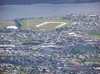
Montrose is a residential locality in the local government area (LGA) of Glenorchy in the Hobart LGA region of Tasmania. The locality is about 1 kilometre (0.62 mi) north of the town of Glenorchy. The 2016 census recorded a population of 2152 for the state suburb of Montrose. It is a suburb of Hobart. The suburb is situated in close proximity with Rosetta. Montrose is the suburb directly north of Glenorchy. It is also in Montrose where the Montrose Foreshore Community Park is located.
Risdon is a suburb of Hobart, capital city of Tasmania. It is west of Risdon Vale.

Derwent Park is a residential locality in the local government area (LGA) of Glenorchy in the Hobart LGA region of Tasmania. The locality is about 2 kilometres (1.2 mi) east of the town of Glenorchy. The 2016 census recorded a population of 657 for the state suburb of Derwent Park. It is a suburb of Hobart.

Lutana is a residential locality in the local government area (LGA) of Glenorchy in the Hobart LGA region of Tasmania. The locality is about 3 kilometres (1.9 mi) south-east of the town of Glenorchy. The 2016 census recorded a population of 2353 for the state suburb of Lutana. It is a suburb of Hobart.
Dowsing Point is a residential locality in the local government area (LGA) of Glenorchy in the Hobart LGA region of Tasmania. The locality is about 2 kilometres (1.2 mi) north-east of the town of Glenorchy. The 2016 census recorded a population of 85 for the state suburb of Dowsing Point.

Granton is a rural residential locality in the local government areas (LGA) of Derwent Valley (80%) and Glenorchy (20%) in the South-east and Hobart LGA regions of Tasmania. The locality is about 9 kilometres (5.6 mi) north of the town of Glenorchy. The 2016 census recorded a population of 1736 for the state suburb of Granton. It is a suburb of Hobart. Rust Road is the approximate boundary between the two municipalities at Granton.

Rose Bay is a suburb of the City of Clarence in greater Hobart, capital city of Tasmania, Australia. Rose Bay is a small suburb, making up only approximately 0.9 square kilometres with nearly one fourth of that area (23.2%) being parkland. At the 2016 Census the suburb recorded a population of 1,102 people.
Naming is a procedure in some Westminster parliaments that provides for the speaker to temporarily remove a member of parliament who is breaking the rules of conduct of the legislature. Historically, "naming" refers to the speaker's invocation of the process by calling out the actual name of the member, deliberately breaking the convention of calling on members by the name of their constituency.

Stephen Patrick Jones is an Australian politician who represents the Division of Whitlam for the Australian Labor Party. He was elected at the 2010 Australian federal election and is the current Assistant Treasurer and Minister for Financial Services.
Refund Home Loans was an Australian mortgage services company founded by Wayne Ormond in 2004. The company created a franchised network of remote working mortgage brokers. After issues with the regulator for breaching trading practices in 2009 it got into financial difficulties. In October 2011, the business went into administration and in June 2012, its assets were sold to rival Australian mortgage company Homeloans Ltd.
The Leader of the Opposition in the Senate is a party office held by the Opposition's most senior member of the Shadow Cabinet in the Australian Senate, elected to lead the opposition party in the body. Though the leader in the Senate does not have the power of the office of Leader of the Opposition, there are some parallels between the latter's status in the lower house and the former's in the Senate. In addition to his or her own shadow ministerial portfolio, the leader has overarching responsibility for all policy areas and acts as the opposition's principal spokesperson in the upper house. The leader is entitled to sit at the table of the Senate, and has priority in gaining recognition from the President of the Senate to speak in debate. Another similarity is that the leader typically announces changes to opposition officeholders in the Senate, including shadow ministers, party leadership and whips. The leader also has some responsibility for appointing opposition senators to committees, a role filled by the Manager of Opposition Business and whips in the lower house. The current leader is Simon Birmingham. He is assisted by a Deputy Leader of the Opposition in the Senate, currently Michaelia Cash.
In the Parliament of Australia, the political parties appoint party whips to ensure party discipline, help manage legislative business and carry out a variety of other functions on behalf of the party leadership. Additional functions of the government party whips is to ensure that a sufficient number of government members and senators are present in the chamber to ensure passage of government legislation and measures and to prevent censure motions succeeding, and to ensure presence of a parliamentary quorum. Their roles in the chamber include tally votes during divisions, and arranging pairs which affects the ability of members and senators to leave parliament during sittings, as well as the entitlement to be absent during divisions.


