Councils of Tasmania are the 29 administrative districts of the Australian state of Tasmania. Local government areas (LGAs), more generally known as councils, are the tier of government responsible for the management of local duties such as road maintenance, town planning and waste management.

Burnie is a port city on the north-west coast of Tasmania, Australia. When founded in 1827, it was named Emu Bay, being renamed after William Burnie, a director of the Van Diemen's Land Company, in the early 1840s.
Waratah-Wynyard Council is a local government body in Tasmania, situated in the north-west of the state. Waratah-Wynyard is classified as a rural local government area and has a population of 13,800, the major towns and localities of the region include Savage River, Sisters Beach, Somerset, Waratah and the principal town of Wynyard.

Wynyard (/ˈwɪnjɚd/) wi-nyuhd) is a rural town located on the North West coast of Tasmania, Australia. Wynyard is situated 17 kilometres (11 mi) west of Burnie. As of the 2021 census, Wynyard has an estimated population of 6,296 The town is a regional hub servicing the surrounding rural areas, the adjacent Burnie Wynyard Airport provides commercial flights to Melbourne and other districts. The main council offices for the Waratah-Wynyard local government area are located in Wynyard.
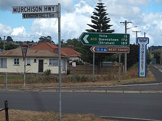
The Murchison Highway is a highway located in the West Coast region of Tasmania, Australia. The 147-kilometre (91 mi) highway runs generally north–south, with Somerset, near Burnie, as its northern terminus and Zeehan as its southern terminus. The highway was opened on 13 December 1963. Part of the highway from Waratah to Burnie was known as the Waratah Highway until 1973.
Guildford is a rural locality in the local government area (LGA) of Waratah–Wynyard in the North-west and west LGA region of Tasmania. The locality is about 81 kilometres (50 mi) south of the town of Wynyard. The 2016 census has a population of nil for the state suburb of Guildford.

Burnie City Council is a local government body in Tasmania, located in the city and surrounds of Burnie in the north-west of the state. The Burnie local government area is classified as urban and has a population of 19,348, which also encompasses Cooee, Hampshire, Natone and Ridgley.

Cooee is a small town on the north-west coast of Tasmania immediately west of Burnie, to which it is in effect a dormitory suburb. At the 2011 census, Cooee had a population of 559.
Hampshire is a semi-rural locality in the local government areas (LGA) of Waratah Wynyard and Burnie in the North-west and west LGA region of Tasmania. The locality is about 30 kilometres (19 mi) south-west of the town of Burnie. The 2016 census has a population of 51 for the state suburb of Hampshire.
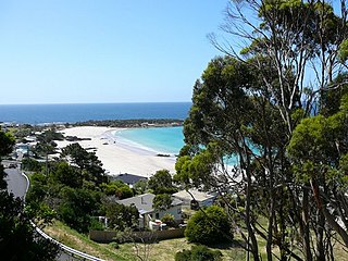
Boat Harbour Beach is a small seaside township located about 15 kilometres (9.3 mi) from Wynyard on the north-west coast of Tasmania. "Boat Harbour" is the name of the locality which surrounds the township. In the 2011 census, Boat Harbour Beach, Boat Harbour and the nearby districts had a population of 429.

The Cam River estuary is located in Somerset roughly halfway between the township of Wynyard and the city of Burnie on the North West Coast of Tasmania. The northern part of the Cam River forms part of the boundary between the City of Burnie and Waratah-Wynyard local government areas.
Camdale is a locality and small rural community in the local government area of Burnie, in the North West region of Tasmania. It is located about 7.5 kilometres (4.7 mi) west of the town of Burnie. The Cam River forms its western boundary, Bass Strait the northern boundary, and the Bass Highway follows the northern boundary. The 2016 census determined a population of 72 for the state suburb of Camdale.
Rocky Cape is a locality and small rural community in the local government areas of Circular Head and Waratah-Wynyard, in the North-west and west region of Tasmania. It is located about 30 kilometres (19 mi) north-west of the town of Wynyard. The Bass Highway passes through from south-east to north-west. The Rocky Cape National Park is in the north-east of the locality. The 2016 census determined a population of 206 for the state suburb of Rocky Cape.
Mount Hicks is a locality and small rural community in the local government area of Waratah-Wynyard in the North West region of Tasmania. It is located about 13 kilometres (8.1 mi) south of the town of Wynyard. The 2016 census determined a population of 351 people for the state suburb of Mount Hicks.
Oonah is a rural locality in the local government areas of Burnie and Waratah-Wynyard in the North West region of Tasmania. It is located about 38 kilometres (24 mi) south-west of the town of Burnie. The 2016 census determined a population of nil for the state suburb of Oonah.
Henrietta is a rural locality in the local government area of Waratah-Wynyard in the North West region of Tasmania. It is located about 25 kilometres (16 mi) south of the town of Wynyard. The 2016 census determined a population of 132 for the state suburb of Henrietta.
Elliott is a rural locality in the local government area of Waratah-Wynyard in the North West region of Tasmania. It is located about 21 kilometres (13 mi) south-east of the town of Wynyard. The 2016 census determined a population of 352 for the state suburb of Elliott.
Corinna is a rural locality in the local government areas of Waratah-Wynyard, Circular Head and West Coast in the North West region of Tasmania. It is located about 138 kilometres (86 mi) south-west of the town of Wynyard. The 2016 census did not determine a separate population for the state suburb of Corinna, which was included in Waratah.
Parrawe is a rural locality in the local government areas (LGA) of Burnie and Waratah–Wynyard in the North-west and west LGA region of Tasmania. The locality is about 58 kilometres (36 mi) south-west of the town of Burnie. The 2016 census recorded a population of nil for the state suburb of Parrawe.


