Hobart is the capital and most populous city of the Australian island state of Tasmania. Home to almost half of all Tasmanians, it is the southernmost and least-populated Australian state capital city, and second-smallest if territories are taken into account, before Darwin, Northern Territory. Hobart is located in Tasmania's south-east on the estuary of the River Derwent, making it the most southern of Australia's capital cities. Its skyline is dominated by the 1,271-metre (4,170 ft) kunanyi/Mount Wellington, and its harbour forms the second-deepest natural port in the world, with much of the city's waterfront consisting of reclaimed land. The metropolitan area is often referred to as Greater Hobart, to differentiate it from the City of Hobart, one of the seven local government areas that cover the city. It has a mild maritime climate.

Tasmania is an island state of Australia. It is located 240 kilometres (150 miles) to the south of the Australian mainland, separated from it by the Bass Strait, with the archipelago containing the southernmost point of the country. The state encompasses the main island of Tasmania, the 26th-largest island in the world, and the surrounding 1000 islands. It is Australia's least populous state, with 569,825 residents as of December 2021. The state capital and largest city is Hobart, with around 40 percent of the population living in the Greater Hobart area.

Launceston or is a city in the north of Tasmania, Australia, at the confluence of the North Esk and South Esk rivers where they become the Tamar River (kanamaluka). As of 2021, Launceston has a population of 87,645. Launceston is the second most populous city in Tasmania after the state capital, Hobart. As of 2020, Launceston is the 18th largest city in Australia. Launceston is the fourth-largest inland city and the ninth-largest non-capital city in Australia. Launceston is regarded as the most livable regional city, and was one of the most popular regional cities to move to in Australia from 2020 to 2021. Launceston was named Australian Town of the Year in 2022.

Mount Wellington ) is a mountain in the southeast of Tasmania, Australia. It is the summit of the Wellington Range and is within Wellington Park reserve. Hobart, Tasmania's capital city, is located at the foot of the mountain.

Burnie is a port city on the north-west coast of Tasmania, Australia. When founded in 1827, it was named Emu Bay, being renamed after William Burnie, a director of the Van Diemen's Land Company, in the early 1840s.

Swansea is a town in the heart of Tasmania's east coast, on the north-west shore of Great Oyster Bay and overlooking Freycinet National Park. It was the first municipality in Australia to be established after Hobart and Sydney. At the 2021 census, Swansea had a population of 997.

Strahan, is a small town and former port on the west coast of Tasmania. It is now a significant locality for tourism in the region.

St Helens is the largest town on the north-east coast of Tasmania, Australia, on Georges Bay. It is known as the game fishing capital of Tasmania and is also renowned for its oysters. It is located on the Tasman Highway, about 160 km east of Tasmania's second largest city, Launceston. In the early 2000s, the town was one of the fastest growing areas of Tasmania, and reached a population of 2049 at the 2006 census. By the time of the 2021 census, it had a population of 2,206.

Zeehan is a town on the west coast of Tasmania, Australia 139 kilometres (86 mi) south-west of Burnie. It is part of the West Coast Council, along with the seaport Strahan and neighbouring mining towns of Rosebery and Queenstown.

Tasmania, the largest island of Australia, has a landmass of 68,401 km2 (26,410 sq mi) and is located directly in the pathway of the notorious "Roaring Forties" wind that encircles the globe. To its north, it is separated from mainland Australia by Bass Strait. Tasmania is the only Australian state that is not located on the Australian mainland. About 2,500 kilometres south of Tasmania island lies the George V Coast of Antarctica. Depending on which borders of the oceans are used, the island can be said to be either surrounded by the Southern Ocean, or to have the Pacific on its east and the Indian to its west. Still other definitions of the ocean boundaries would have Tasmania with the Great Australian Bight to the west, and the Tasman Sea to the east. The southernmost point on mainland Tasmania is approximately 43°38′37″S146°49′38″E at South East Cape, and the northernmost point on mainland Tasmania is approximately 40°38′26″S144°43′33″E in Woolnorth / Temdudheker near Cape Grim / Kennaook. Tasmania lies at similar latitudes to Te Waipounamu / South Island of New Zealand, and parts of Patagonia in South America, and relative to the Northern Hemisphere, it lies at similar latitudes to Hokkaido in Japan, Northeast China (Manchuria), the north Mediterranean in Europe, and the Canada-United States border.

Orford is a village on the east coast of Tasmania, Australia 73 kilometres north-east of Hobart. It is the home of the joint champions of T20 Cricket in Tasmania. The village is centred on the mouth of the Prosser River, on the southern margin of a substantial coastal inlet called Prosser Bay. Beyond this bay are the waters of the Mercury Passage. At the 2006 census, Orford had a population of 553.

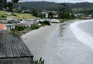
Scamander is a small town at the mouth of the Scamander River between St Helens and St Marys on the north-east coast of Tasmania in Australia. The town is a popular holiday destination because of its wide, sandy beaches and views of the ocean. Recreational activities include surfing, swimming and fishing for bream in the river.
Stanley is a town on the north-west coast of Tasmania, Australia. It is the second-last major township on the north-west coast when travelling west, Smithton being the larger township in the Circular Head municipality. According to the 2021 census, Stanley had a population of 595.

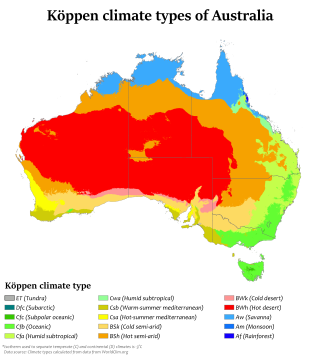
Australia's climate is governed mostly by its size and by the hot, sinking air of the subtropical high pressure belt. This moves north-west and north-east with the seasons. The climate is variable, with frequent droughts lasting several seasons, thought to be caused in part by the El Niño-Southern Oscillation. Australia has a wide variety of climates due to its large geographical size. The largest part of Australia is desert or semi-arid. Only the south-east and south-west corners have a temperate climate and moderately fertile soil. The northern part of the country has a tropical climate, varying between grasslands and desert. Australia holds many heat-related records: the continent has the hottest extended region year-round, the areas with the hottest summer climate, and the highest sunshine duration.
Port Davey is an oceanic inlet located in the south west region of Tasmania, Australia.

Triabunna is a rural residential locality in the local government area (LGA) of Glamorgan–Spring Bay in the South-east LGA region of Tasmania. The locality is about 86 kilometres (53 mi) north-east of the city of Hobart. The 2021 census has a population of 905 for the state suburb of Triabunna.
The Low Rocky Point is a location on the south west coast of Tasmania and Australia, that is used as a location for weather forecasting. It is almost due west of Hobart, it is south of Point Hibbs and north of South West Cape.

Tasmania has a cool temperate climate with four distinct seasons. The highest recorded maximum temperature in Tasmania is 42.2 °C (108.0 °F) at Scamander on 30 January 2009, during the 2009 southeastern Australia heat wave. Tasmania's lowest recorded minimum temperature is −14.2 °C (6.4 °F) on 7 August 2020, at Central Plateau.

Liawenee is a small town in Tasmania, Australia built near Great Lake and the River Ouse, and was established on 11 June 1920. The town is an ex-Hydro village and now a residence for Inland Fisheries Services (IFS) and a Tasmania Police station. It is known for its exceptional fishing at nearby Great Lake and hosts several trout fishing events.

Southport is a small township in far south Tasmania, the most southern township in Australia. The town had a population of 149 in 2021. It was settled in 1837 and grew to be the largest town south of Hobart; but a declining shipping industry slowly led to the town's shrinking population, and much of it has been destroyed by fire. Shore-based whaling took place at Southport in the 19th century.


