The Oyster Rocks are a close pair of small granite islands, with a combined area of about 6 ha, in south-eastern Australia. They are part of Tasmania’s Tin Kettle Island Group, lying in eastern Bass Strait between Flinders and Cape Barren Islands in the Furneaux Group. They are a conservation area. The islands are part of the Franklin Sound Islands Important Bird Area, identified as such by BirdLife International because it holds over 1% of the world populations of six bird species.
Little Stony Petrel Island is an island game reserve with an area of 4 ha, in south-eastern Australia. It is part of the Petrel Island Group, lying in Bass Strait close to Walker and Robbins Islands in north-west Tasmania.
Big Stony Petrel Island is an island game reserve with an area of 7.2 ha, in south-eastern Australia. It is part of the Petrel Island Group, lying in Bass Strait close to Walker and Robbins Islands in north-west Tasmania.
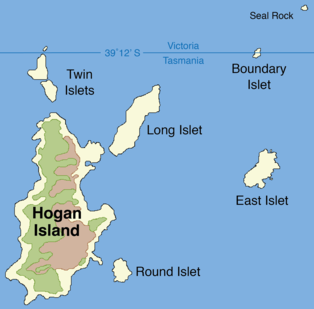
East Island is a granite island, with an area of 12.42 ha, in south-eastern Australia. It is part of Tasmania’s Hogan Group, lying in northern Bass Strait between the Furneaux Group and Wilsons Promontory in Victoria.
South East Great Dog Islet is a small granite island, with an area of 0.6 ha, in south-eastern Australia. It is part of Tasmania’s Great Dog Island Group, lying in eastern Bass Strait between Flinders and Cape Barren Islands in the Furneaux Group. It is very close to the south-eastern end of Great Dog Island.

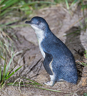
Fisher Island is a small granite island, with an area of 0.9 ha, in south-eastern Australia. It is part of Tasmania’s Great Dog Island Group, lying in eastern Bass Strait between Flinders and Cape Barren Islands in the Furneaux Group. It is the site of a long-term, ongoing study of short-tailed shearwaters.
Ram Island is a small mudstone and dolerite island, with an area of 1 ha, in south-eastern Australia. It is part of Tasmania’s Vansittart Island Group, lying in eastern Bass Strait between Flinders and Cape Barren Islands in the Furneaux Group. It is privately owned.
Pelican Island is an island, with an area of 6.8 ha including an associated reef joined to it at low tide, in south-eastern Australia. It is part of Tasmania’s Vansittart Island Group, lying in eastern Bass Strait between Flinders and Cape Barren Islands in the Furneaux Group. Until 1984 it was leased for grazing. The island is part of the Franklin Sound Islands Important Bird Area, identified as such by BirdLife International because it holds over 1% of the world populations of six bird species.
Tucks Reef is a small rocky island, with an area of 1.14 ha, in south-eastern Australia. It is part of Tasmania’s Vansittart Island Group, lying in eastern Bass Strait between Flinders and Cape Barren Islands in the Furneaux Group.

Sentinel Island is a granite island, with an area of 10 ha, in south-eastern Australia. It is part of Tasmania’s Sentinel Island Group, lying in eastern Bass Strait off the north-west coast of Flinders Island in the Furneaux Group. Until 1985 it was used for grazing sheep.
Little Island is a granite island, with an area of 3 ha, in south-eastern Australia. It is part of Tasmania’s Sentinel Island Group, lying in eastern Bass Strait off the north-west coast of Flinders Island in the Furneaux Group.
South Pasco Island is an island, with an area of 21 ha, in south-eastern Australia. It is part of Tasmania’s Pasco Island Group, lying in eastern Bass Strait off the north-west coast of Flinders Island in the Furneaux Group. It is used for grazing sheep.
The Low Islets are two small, flat, adjacent, granite islands, with a combined area of about 2 ha, in south-eastern Australia. They are part of Tasmania’s Prime Seal Island Group, lying in eastern Bass Strait west of Flinders in the Furneaux Group. The larger of the two islets has been used for grazing sheep, cattle and horses.
Wybalenna Island comprises four round granite islands with a combined area of about 16 ha, in south-eastern Australia. It is part of Tasmania’s Prime Seal Island Group, lying in eastern Bass Strait west of Flinders in the Furneaux Group. The island is a conservation area

The Little Swan Island, part of the Waterhouse Island Group, is a 12.64-hectare (31.2-acre) uninhabited granite island situated in Banks Strait, part of Bass Strait, lying close to the north-eastern coast of Tasmania, Australia.
The St Helens Island, part of the Waterhouse Island Group, is a 51-hectare (130-acre) granite island situated in the Tasman Sea, lying close to the north-eastern coast of Tasmania, Australia.
Ile des Phoques is a rugged granite island, with an area of 8 ha, part of the Schouten Island Group, lying close to the eastern coast of Tasmania, Australia near the Freycinet Peninsula.
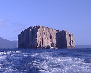
Hippolyte Rocks is a small granite island, with an area of 5.3 ha, in south-eastern Australia. It is part of the Tasman Island Group, lying close to the south-eastern coast of Tasmania around the Tasman Peninsula. It has a flat top and is surrounded by steep cliffs up to 65 m in height. It is part of the Tasman National Park.
Visscher Island is an island, with an area of 3.4 ha, in south-eastern Tasmania, in Australia.

St Helens Important Bird Area comprises four separate sites, with a collective total area of 24 km2, in the vicinity of the town of St Helens on the northern part of the east coast of Tasmania, south-eastern Australia.