
Abel Janszoon Tasman was a Dutch seafarer, explorer, and merchant, best known for his voyages of 1642 and 1644 in the service of the Dutch East India Company (VOC). He was the first known European explorer to reach New Zealand and the islands of Fiji and Van Diemen's Land.

Tasmania is an island state of Australia. It is located 240 km (150 mi) to the south of the Australian mainland, separated from it by Bass Strait. The state encompasses the main island of Tasmania, the 26th-largest island in the world, and the surrounding 1000 islands. It is Australia's least populated state, with 541,965 residents as of March 2021. The state capital and largest city is Hobart, with around 40 percent of the population living in the Greater Hobart area.
Margate is a small seaside town on the Channel Highway between North-West Bay and the Snug Tiers, 7 kilometres (4 mi) south of Kingston in Tasmania, Australia. It is mostly in the Kingborough Council area, with about 4% in the Huon Valley Council LGA.

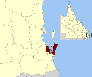
Clarence City Council is a local government body in Tasmania, and one of the five municipalities that constitutes the Greater Hobart Area. The Clarence local government area has a population of 56,945, covering the eastern shore of the Derwent River from Otago to the South Arm Peninsula and the smaller localities of Cambridge, Richmond, and Seven Mile Beach.

Cape Barren Island, officially truwana / Cape Barren Island, is a 478-square-kilometre (185 sq mi) island in the Bass Strait, off the north east coast of Tasmania, Australia. It is the largest island of the Furneaux Group; Flinders Island lies to the north, with the smaller Clarke Island to the south. The highest point on the island is Mount Munro at 715 metres (2,346 ft). Mount Munro is probably named after James Munro, a former convict and then sealer, who lived from the 1820s for more than 20 years with several women on nearby Preservation Island.
Redland City, better known as the Redlands and formerly known as Redland Shire, is a local government area and a part of the Brisbane metropolitan area in South East Queensland. With a population of 156,863 in June 2018, the city is spread along the southern coast of Moreton Bay, covering 537.2 square kilometres (207.4 sq mi). Its mainland borders the City of Brisbane to the west and north-west, and Logan City to the south-west and south, while its islands are situated north of the City of Gold Coast.
The Christian Reformed Churches of Australia (CRCA), formerly known as the Reformed Churches of Australia (RCA) is a Christian denomination established in Australia belonging to the Reformed/Presbyterian tradition.

The Colonial sloop Norfolk was built on Norfolk Island in 1798 of Norfolk Island Pine. She was wrecked in 1800.

The electoral division of Pembroke is one of the 15 electorates or 'seats' in the Tasmanian Legislative Council or upper house. It is located on Hobart's Eastern Shore and includes a number of suburbs; Risdon Vale, Geilston Bay, Rose Bay, Lindisfarne, Warrane, Mornington, Bellerive, Howrah and Tranmere. In earlier times, the division included most of the east coast of Tasmania as far north as Bicheno, including the Tasman Peninsula.

Pedra Branca is a rock islet or small island, located in the Southern Ocean, off the southern coast of Tasmania, Australia. The island is situated approximately 26 km (16 mi) south southeast of South East Cape and is contained within the Southwest National Park, part of the Tasmanian Wilderness World Heritage Site. An erosional remnant of the Tasmanian mainland, the island is approximately 270 m (890 ft) long, 100 m (330 ft) wide, with an elevation of 60 m (200 ft) above sea level. The island is estimated to have separated from the Tasmanian mainland at least 15,000 years ago.
The Hunter Island, the main island of the Hunter Island Group, is a 7,330-hectare (18,100-acre) island, located in Bass Strait, that lies between King Island and north-west Tasmania, Australia.

Fahan School is an independent school for girls located in Sandy Bay, a suburb of Hobart, Tasmania, Australia. It is a non-denominational school with a Christian ethos.
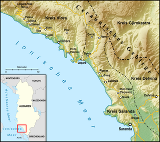
The Albanian Riviera, also popularly known as Bregu, is a coastline along the Northeastern Ionian Sea in the Mediterranean Sea encompassing the districts of Sarandë and Vlorë in Southwestern Albania. It forms an important section of the Albanian Ionian Sea Coast dotted with the villages of Palasë, Dhërmi, Vuno, Himara, Qeparo, Borsh, Piqeras, Lukovë and the city of Sarandë.

Visa requirements for Danish citizens are administrative entry restrictions by the authorities of other states placed on citizens of the Kingdom of Denmark as a sovereign state comprising the three constituent countries: Denmark, Greenland and the Faroe Islands.
The Norfolk Bay is a body of water in the south east of Tasmania, Australia. The north west aspect of Norfolk Bay is continuous with Frederick Henry Bay. The north east aspect of Norfolk Bay is continuous with Blackman Bay via the Denison Canal.
Tasmania's offshore islands: seabirds and other natural features is a book published by the Tasmanian Museum and Art Gallery in 2001. The book is considered an essential measure of the state of Tasmania's islands, birds inhabiting them, and the condition of the islands. The main author was Nigel Brothers, a Hobart based biologist, the other contributors were Vanessa Halley, Helen Pryor, and David Pemberton.
The Tasmanian archipelago is made up of 334 islands. This book highlights the uniqueness and importance of 280, as significant breeding refuges and wealthy natural resources. Islands are documented with descriptions of topography, wildlife, vegetation and full-colour photographs."
This article outlines the history of Smooth Island, popularly known as Garden Island, in Norfolk Bay, Tasmania. The names come from the island's gently undulating topography and lush vegetation in comparison with the stony mainland. It has been privately owned since 1864.
