
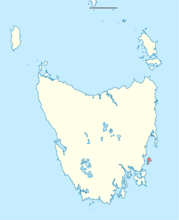
Tasmania is an island state of Australia. It is located 240 km (150 mi) to the south of the Australian mainland, separated from it by the Bass Strait. The state encompasses the main island of Tasmania, the 26th-largest island in the world, and the surrounding 1000 islands. It is Australia's least populated state, with 541,965 residents as of March 2021. The state capital and largest city is Hobart, with around 40 percent of the population living in the Greater Hobart area.

Bass Strait is a strait separating the island state of Tasmania from the Australian mainland. The strait provides the most direct waterway between the Great Australian Bight and the Tasman Sea, and is also the only maritime route into the economically prominent Port Phillip Bay.

The Great Australian Bight is a large oceanic bight, or open bay, off the central and western portions of the southern coastline of mainland Australia.

Macquarie Harbour is a shallow inlet located in the West Coast region of Tasmania, Australia. It is approximately 315 sq.km, and has an average depth of 15m, with deeper places up to 50m. It is navigable by shallow-draft vessels. The main channel is kept clear by the presence of a rock wall on the outside of the channel's curve. This man-made wall prevents erosion and keeps the channel deep and narrow, rather than allowing the channel to become wide and shallow. A reported Aboriginal name for the harbour is Parralaongatek.

Bruny Island is a 362-square-kilometre (140 sq mi) island located off the south-eastern coast of Tasmania, Australia. The island is separated from the Tasmanian mainland by the D'Entrecasteaux Channel, and its east coast lies within the Tasman Sea. Storm Bay is located to the island's northeast. Both the island and the channel are named after French explorer, Antoine Bruni d'Entrecasteaux. Its traditional Aboriginal name is lunawanna-allonah, which survives as the name of two island settlements, Alonnah and Lunawanna.

Cetacean stranding, commonly known as beaching, is a phenomenon in which whales and dolphins strand themselves on land, usually on a beach. Beached whales often die due to dehydration, collapsing under their own weight, or drowning when high tide covers the blowhole. Cetacean stranding has occurred since before recorded history.

King George Sound is the name of a sound on the south coast of Western Australia. Originally named King George the Third's Sound, it was referred to as King George's Sound from 1805. The name "King George Sound" gradually came into use from about 1934, prompted by new Admiralty charts supporting the intention to eliminate the possessive 's' from geographical names.
Maria Island or 'wukaluwikiwayna' in [palawa kani) is a mountainous island located in the Tasman Sea, off the east coast of Tasmania, Australia. The 115.5-square-kilometre (44.6 sq mi) island is contained within the Maria Island National Park, which includes a marine area of 18.78 square kilometres (7.25 sq mi) off the island's northwest coast. The island is about 20 kilometres (12 mi) in length from north to south and, at its widest, is about 13 kilometres (8.1 mi) west to east. At its closest point, Point Lesueur, the island lies approximately 4 kilometres (2.5 mi) off the east coast of Tasmania.

The Clarke Island, part of the Furneaux Group, is an 82-square-kilometre (32 sq mi) island in Bass Strait, south of Cape Barren Island, about 24 kilometres (15 mi) off the northeast coast of Tasmania, Australia. Banks Strait separates the island from Cape Portland on the mainland.
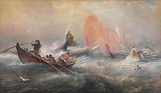
Whaling in Australian waters began in 1791 when five of the 11 ships in the Third Fleet landed their passengers and freight at Sydney Cove and then left Port Jackson to engage in whaling and seal hunting off the coast of Australia and New Zealand. The two main species hunted by such vessels in the early years were right and sperm whales. Humpback, bowhead and other whale species would later be taken.

The Westpac Lifesaver Rescue Helicopter Service is a helicopter surf lifesaving service that operates in Australia.

Pedra Branca is a rock islet or small island, located in the Southern Ocean, off the southern coast of Tasmania, Australia. The island is situated approximately 26 km (16 mi) south southeast of South East Cape and is contained within the Southwest National Park, part of the Tasmanian Wilderness World Heritage Site. An erosional remnant of the Tasmanian mainland, the island is approximately 270 m (890 ft) long, 100 m (330 ft) wide, with an elevation of 60 m (200 ft) above sea level. The island is estimated to have separated from the Tasmanian mainland at least 15,000 years ago.

Eddystone is a tower-shaped rock or small island, located in the Southern Ocean, off the southern coast of Tasmania, Australia. The island is situated approximately 27 km (17 mi) from the South East Cape on a bearing of 149° and is contained within the Southwest National Park, part of the Tasmanian Wilderness World Heritage Site. An erosional remnant of the Tasmanian mainland with an elevation of 30 m (98 ft) above sea level, the island is estimated to have separated from the Tasmanian mainland at least 15,000 years ago.
The south coast of Western Australia comprises the Western Australian coastline from Cape Leeuwin to Eucla. This is a distance of approximately 1,600 kilometres (1,000 mi), fronting the Great Australian Bight and the Southern Ocean.

The Hibbs Pyramid is a pyramidal dolerite island, located in the Indian Ocean, off the south western coast of Tasmania, Australia. The island is contained within the Southwest National Park, part of the Tasmanian Wilderness World Heritage Site.
Tasmania is an island territory, south of the Australian mainland.
Robbins Island is a 9,900-hectare (24,000-acre) island located in Bass Strait, lying off the northwest coast of Tasmania, Australia. The island, separated from the Tasmanian mainland by a highly tidal area known as Robbins Passage, lies south to the adjacent Walker Island.
The Ngari Capes Marine Park is a marine protected area on the lower south west coast of Western Australia, located approximately 250 kilometres (160 mi) south of Perth. The 123,790-hectare (305,900-acre) marine park was gazetted on 12 June 2012 and the park's western and southern boundaries are the limit of coastal waters of Western Australia, abutting the South-west Corner Marine Park located within the Australian Commonwealth exclusive economic zone.
The Tasmanian Seafarers' Memorial is a public memorial structure located at Triabunna, Tasmania which jointly commemorates all Tasmanians whose lives were lost at sea, along with the lives of all seafarers of any origin who lost their lives in Tasmanian waters. The memorial comprises individual commemorative plaques for each maritime tragedy involving recreational, commercial, mercantile or naval vessels and personnel lost since 1803. As-at February 2017, the memorial contained plaques for 116 tragic events involving the loss of over 1450 lives.

