Related Research Articles

Kingston is a town on the outskirts of Hobart, Tasmania, Australia. Nestled 12 km south of the city between and around several hills, Kingston is the seat of the Kingborough Council, and today serves as the gateway between Hobart and the D'Entrecasteaux Channel region, which meets the Derwent River nearby. It is one of the fastest-growing regions in Tasmania. The Kingston-Huntingfield statistical area had an estimated population of 11,200 in June 2012.

Huonville is a town on the Huon River, in the south-east of Tasmania, Australia. It is the seat of the Huon Valley Council area and lies 38 km south of Hobart on the Huon Highway. At the 2016 census, Huonville had a population of 2,714 and at the 2011 census had a population of 1,741.

Antoine Raymond Joseph de Bruni, chevalier d'Entrecasteaux was a French naval officer, explorer and colonial governor. He is perhaps best known for his exploration of the Australian coast in 1792, while searching for the La Pérouse expedition. Antoine Bruni d'Entrecasteaux is commonly referred to simply as Bruni d'Entrecasteaux or Bruny d'Entrecasteaux, which is a compound surname.

The Huon River is a perennial river located in the south-west and south-east regions of Tasmania, Australia. At 174 kilometres (108 mi) in length, the Huon River is the fifth-longest in the state, with its course flowing east through the fertile Huon Valley and emptying into the D'Entrecasteaux Channel, before flowing into the Tasman Sea.
Cygnet is a town in the Huon Valley, south of Huonville, Tasmania.

The D'Entrecasteaux Channel is a body of water located between Bruny Island and the south-east of the mainland of Tasmania, Australia. The channel is the mouth for the estuaries of the Derwent and the Huon Rivers and empties into the Tasman Sea of the South Pacific Ocean. It was sighted by Abel Tasman in 1642 and surveyed in 1792 by Bruni d'Entrecasteaux.

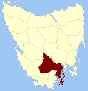
The Huon Valley, or simply the Huon, is a valley and geographic area located in southern Tasmania, Australia. The largest town is Huonville, with other smaller towns spread across the area. It includes Australia's most southern permanent settlement at Southport. The Huon Valley Council area had a population of 15,140 in 2011. Famed for its apple growing, the Valley was first settled by British colonists in the 1820s; prior to settlement the Huon Valley area was inhabited by the Mouheneenner, Nuenonne, Mellukerdee and Lyluequonny people.
Cradoc is a rural residential locality in the local government area of Huon Valley in the South-east region of Tasmania. It is located about 11 kilometres (6.8 mi) south-west of the town of Huonville. The 2016 census has a population of 445 for the state suburb of Cradoc.
Buckingham Land District is one of the twenty land districts of Tasmania which are part of the Lands administrative divisions of Tasmania. It was formerly Buckingham County, one of the 18 counties of Tasmania and one of the first eleven proclaimed in 1836 and is bordered to the north by the River Derwent, and to the south by the Huon River. It includes Bruny Island. Hobart is located in the county. It was named after the then county of England.
Huon Island is an island with an area of 47 hectares in south-eastern Australia. It is part of the Partridge Island Group, lying close to the south-eastern coast of Tasmania, in the D'Entrecasteaux Channel between Bruny Island and the mainland. The island has a small human population and has been subjected to intensive agricultural activities in the past. The Nuenonne name of the island is Prahree.
Sloping Island, incorporating the adjacent Sloping Reef, is an island nature reserve, with an area of 117 ha, in Tasmania in south-eastern Australia. It is part of the Sloping Island Group, lying close to the south-eastern coast of Tasmania around the Tasman and Forestier Peninsulas.

Smooth Island, is a privately owned island with an area of 59.31 ha lying close to the south-eastern coast of Tasmania, Australia. The island is part of the Sloping Island Group situated in Norfolk Bay and surrounded by the Tasman and Forestier Peninsulas. The towns Dunalley and Murdunna are nearby. Smooth Island differs from other Tasmanian islands as it has an unencumbered freehold title down to the high-water mark.
Green Island is a small island nature reserve with an area of 4.17 ha close to the south-eastern coast of Tasmania, Australia at the entrance to the River Derwent.
Arch Rock is a sandstone islet, with an area of 0.44 ha and containing a natural arch, in south-eastern Australia. It is part of the Partridge Island Group, lying close to the south-eastern coast of Tasmania, in the D'Entrecasteaux Channel between Bruny Island and the mainland.
Charity Island is an islet with an area of 0.6 ha in south-eastern Australia. It is part of the Partridge Island Group, lying close to the south-eastern coast of Tasmania, in the D'Entrecasteaux Channel between Bruny Island and the mainland. Its neighbouring islets are named "Faith" and "Hope".

The Partridge Island, part of the Partridge Island Group, is an 103-hectare (250-acre) island that lies close to the south-eastern coast of Tasmania, Australia. The island is situated in the D'Entrecasteaux Channel, between Bruny Island and the mainland of Tasmania and is part of the South Bruny National Park.
Satellite Island is a small island, part of the Partridge Island Group, lying close to the south-eastern coast of Tasmania, in the D'Entrecasteaux Channel between Bruny Island and the Tasmanian mainland. It is surrounded by an ancient fossil clad rock shelf, home to an array of local shellfish, including crayfish, native scallops, abalone and oysters. Satellite Island was discovered in 1792 by the French expedition led by Bruni D'Entrecasteaux. It was originally used as an observatory for the night sky.
The Hope Island, part of the Partridge Island Group, is a small island that lies close to the south-eastern coast of Tasmania, Australia. The island is located in the D'Entrecasteaux Channel between Bruny Island and the Tasmanian mainland. Its neighbouring islets are named Faith and Charity, and also the Arch Rock.
The Faith Island, part of Partridge Island Group, is a low, flat islet in south-eastern Tasmania, Australia. The islet lies in the D'Entrecasteaux Channel between Bruny Island and the Tasmania mainland. It contains two gravestones, concealed in the scrub in the north-east of the island. Its neighbouring islets are named Charity and Hope and also the Arch Rock.
Seagull Rock is a small islet in south-eastern Australia. It is part of the Partridge Island Group, lying close to the south-eastern coast of Tasmania, in the D'Entrecasteaux Channel between Bruny Island and the mainland.
References
- ↑ Brothers (2001), p.607.
- ↑ "A Brief History of the George Town District". www.gtdhs.com. George Town and District Historical Society Inc. Retrieved 1 December 2018.
- ↑ "PH30-1-648". Libraries Tasmania's Online collection. Retrieved 1 December 2018.
- ↑ Cronly, B.1j (8 October 1947). "Place Names". The Mercury (Hobart) . p. 3. Retrieved 1 December 2018.
- ↑ Brothers (2001), p.607.
Sources
- Brothers, Nigel; Pemberton, David; Pryor, Helen; & Halley, Vanessa. (2001). Tasmania’s Offshore Islands: seabirds and other natural features. Tasmanian Museum and Art Gallery: Hobart. ISBN 0-7246-4816-X
Robert Barr owned garden island 1991 to 2009
Coordinates: 43°15′S147°07′E / 43.250°S 147.117°E
Southern region of Tasmania, Australia | |||||
|---|---|---|---|---|---|
| City Other settlements | |||||
| Governance | |||||
| Mountains | |||||
| Protected areas, parks and reserves | |||||
| Rivers | |||||
| Harbours, bays, inlets and estuaries | |||||
| Coastal features | |||||
| Transport | |||||
| Landmarks |
| ||||
| Islands | |||||
| Books and newspapers | |||||
| Flora, fauna, and fishlife | |||||
| Bioregions | |||||
| Indigenous heritage | |||||
| Other | |||||
| | This Tasmania geography article is a stub. You can help Wikipedia by expanding it. |