The Shanks Islands form a group of five small rocky islets located close to the south-western coast of Tasmania, Australia. Situated near where the mouth of Port Davey meets the Southern Ocean, the islets have a combined area of 2.72 hectares and are part of the Swainson Islands Group. They comprise part of the Southwest National Park and the Tasmanian Wilderness World Heritage Site.

The Trumpeter Islets comprise a group of two unpopulated islets, with a combined area of about a hectare, located close to the south-western coast of Tasmania, Australia. Situated some 6 kilometres (3.7 mi) where the mouth of Port Davey meets the Southern Ocean, the 1-hectare (2.5-acre) island is part of the Trumpeter Islets Group, and comprises part of the Southwest National Park and the Tasmanian Wilderness World Heritage Site.
The Oyster Rocks are a close pair of small granite islands, with a combined area of about 6 ha, in south-eastern Australia. They are part of Tasmania’s Tin Kettle Island Group, lying in eastern Bass Strait between Flinders and Cape Barren Islands in the Furneaux Group. They are a conservation area. The islands are part of the Franklin Sound Islands Important Bird Area, identified as such by BirdLife International because it holds over 1% of the world populations of six bird species.

The Needle Rocks, also known as the Needles, are a group of five main rock islets located close to the south-western coast of Tasmania, Australia. With a combined area of approximately 10.5 hectares (0.041 sq mi), the islets are part of the Maatsuyker Islands Group, and comprise part of the Southwest National Park and the Tasmanian Wilderness World Heritage Site.
Craggy Island is a rugged granite island, with an area of 38.88 ha, in south-eastern Australia. It is part of Tasmania’s Bass Pyramid Group lying in northern Bass Strait between Flinders Island and the Kent Group.

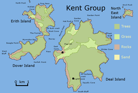
Dover Island, the third largest island in the Kent Group, is a densely vegetated and unpopulated 295-hectare (730-acre) granite island with steep slopes, located in the Bass Strait, lying off the north-east coast of Tasmania, between the Furneaux Group and Wilsons Promontory in Victoria, Australia.
Erith Island, the second largest island in the Kent Group, is a densely vegetated and unpopulated 323-hectare (800-acre) granite island with steep slopes, located in the Bass Strait, lying off the north-east coast of Tasmania, between the Furneaux Group and Wilsons Promontory in Victoria, Australia.
The North East Isle, part of the Kent Group, is an unpopulated 32.62-hectare (80.6-acre) granite island, located in the Bass Strait, lying off the north-east coast of Tasmania, between the Furneaux Group and Wilsons Promontory in Victoria, Australia.
The South West Isle, part of the Kent Group, is an unpopulated 19.09-hectare (47.2-acre) granite island, located in the Bass Strait, lying off the north-east coast of Tasmania, between the Furneaux Group and Wilsons Promontory in Victoria, Australia.
The Bass Pyramid, part of the Furneaux Group, is a small, two sectioned oval, steep-sided 100-square-metre (1,100 sq ft) unpopulated granite island, located in Bass Strait, lying north of the Flinders Island and south of the Kent Group, in Tasmania, Australia. A rock bridge connects the two sections.

The Passage Island, part of the Passage Group within the Furneaux Group, is a 253-hectare (630-acre) granite and dolerite island, located in Bass Strait south of Cape Barren Island, in Tasmania, in south-eastern Australia.
The Forsyth Island, part of the Passage Group within the Furneaux Group, is a 167-hectare (410-acre) granite island, located in Bass Strait south of Cape Barren Island, in Tasmania, in south-eastern Australia. With the Passage and Gull islands, the Forsyth Island forms part of the Forsyth, Passage and Gull Islands Important Bird Area (IBA), identified as such by BirdLife International because it supports over 1% of the world populations of little penguins and black-faced cormorants.

The Moriarty Rocks, part of the Passage Group within the Furneaux Group, are a group of two major unpopulated granite rocks, and several smaller ones, with a combined area of 2.46 hectares, located in Bass Strait, south of Cape Barren Island, west of the Low Islets, and west of the Spike and Clarke islands, in Tasmania, in south-eastern Australia. The rocks are contained within a nature reserve.
The North West Mount Chappell Islet, part of the Badger Group within the Furneaux Group, is a 7,100-square-metre (76,000 sq ft) unpopulated mainly granite islet, in Bass Strait, lying west of the Flinders and Cape Barren islands, Tasmania, south of Victoria, in south-eastern Australia. The island is located within a conservation area and is part of the Chalky, Big Green and Badger Island Groups Important Bird Area.

The Babel Island, part of the Babel Group within the Furneaux Group, is a 440-hectare (1,100-acre) granite island, located in Bass Strait, lying off the east coast of Flinders Island, Tasmania, south of Victoria, Australia. The privately owned island was named by Matthew Flinders from the noises made by the seabirds there.
The Low Islets are two small, flat, adjacent, granite islands, with a combined area of about 2 ha, in south-eastern Australia. They are part of Tasmania’s Prime Seal Island Group, lying in eastern Bass Strait west of Flinders in the Furneaux Group. The larger of the two islets has been used for grazing sheep, cattle and horses.

The Foster Islands, part of the Waterhouse Island Group, are two small granite islands with a combined area of 48 hectares situated in Banks Strait, part of Bass Strait, lying close to the north-eastern coast of Tasmania, Australia. The islands form part of Small Bass Strait Island nature reserve.
The George Rocks, also historically known as King George's Rocks, is part of the Waterhouse Island Group, a group of three adjacent uninhabited granite islets and associated reefs with a combined area of 7 hectares, situated in Banks Strait, part of Bass Strait, lying close to the north-eastern coast of Tasmania, Australia.

The East Pyramids comprise a group of three steep, rocky unpopulated islets located close to the south-western coast of Tasmania, Australia. Situated some 2 kilometres (1.2 mi) south of where the mouth of Port Davey meets the Southern Ocean, the 6.69-hectare (16.5-acre) islets are one of the eight islands that comprise the Mutton Bird Islands Group. The East Pyramids are part of the Southwest National Park and the Tasmanian Wilderness World Heritage Site.
West Pyramid is an unpopulated steep-sided island located close to the south-western coast of Tasmania, Australia. Situated some 1 kilometre (0.62 mi) north of the mouth of Port Davey where it meets the Southern Ocean, the 2.5-hectare (6.2-acre) island is part of the Trumpeter Islets Group, and comprises part of the Southwest National Park and the Tasmanian Wilderness World Heritage Site.