Waterhouse Island, part of the Waterhouse Island Group, is a 287-hectare (710-acre) granite island situated in Banks Strait, part of Bass Strait, lying close to the north-eastern coast of Tasmania, Australia.

The Breaksea Islands Group is a group of six islands, located in the Southern Ocean, off the south western coast of Tasmania, Australia.

Schouten Island, part of the Schouten Island Group, is an island with an area of approximately 28 square kilometres (11 sq mi) lying close to the eastern coast of Tasmania, Australia, located 1.6 kilometres (0.99 mi) south of the Freycinet Peninsula and is a part of Freycinet National Park. The Paredarerme name for the island is Tiggana marraboona.

Craggy Island is a rugged granite island, with an area of 38.88 ha, in south-eastern Australia. It is part of Tasmania’s Bass Pyramid Group lying in northern Bass Strait between Flinders Island and the Kent Group.

The Judgement Rocks, part of the Kent Group, is a small unpopulated 0.39-hectare (0.96-acre) granite islet and some associated bare rocks, located in the Bass Strait, lying off the north-east coast of Tasmania, between the Furneaux Group and Wilsons Promontory in Victoria, Australia. The islet and associated rocks are contained within the Kent Group National Park.
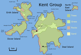
Deal Island, the largest island of the Kent Group, is a 1,576-hectare (3,890-acre) granite island, located in northern Bass Strait, that lies between the Furneaux Group, north-east of Tasmania and Wilsons Promontory in Victoria, Australia.
Dover Island, the third largest island in the Kent Group, is a densely vegetated and unpopulated 295-hectare (730-acre) granite island with steep slopes, located in the Bass Strait, lying off the north-east coast of Tasmania, between the Furneaux Group and Wilsons Promontory in Victoria, Australia.
The North East Isle, part of the Kent Group, is an unpopulated 32.62-hectare (80.6-acre) granite island, located in the Bass Strait, lying off the north-east coast of Tasmania, between the Furneaux Group and Wilsons Promontory in Victoria, Australia.
The South West Isle, part of the Kent Group, is an unpopulated 19.09-hectare (47.2-acre) granite island, located in the Bass Strait, lying off the north-east coast of Tasmania, between the Furneaux Group and Wilsons Promontory in Victoria, Australia.

The Passage Island, part of the Passage Group within the Furneaux Group, is a 253-hectare (630-acre) granite and dolerite island, located in Bass Strait south of Cape Barren Island, in Tasmania, in south-eastern Australia.
Badger Island, part of the Badger Group within the Furneaux Group, is a 1,242-hectare (3,070-acre) unpopulated low-lying granite and limestone island, located in Bass Strait, lying west of the Flinders and Cape Barren islands, Tasmania, south of Victoria, in south-eastern Australia.

The Great Dog Island, also known as Big Dog Island, and part of the Great Dog Group within the Furneaux Group, is a 354-hectare (870-acre) granite island, located in Bass Strait, lying south of the Flinders Island and north of the Cape Barren Island, in Tasmania, in south-eastern Australia.

Inner Sister Island, part of the Sister Islands Conservation Area, is a granite and dolerite island, with an area of 748 hectares (2.89 sq mi), located in Bass Strait, Tasmania, Australia.

Outer Sister Island, part of the Sister Islands Conservation Area, is a granite and dolerite island, with an area of 545 hectares (2.10 sq mi), located in Bass Strait, Tasmania, Australia.

Prime Seal Island is a long island, with a high central ridge and an area of 1220 ha, in south-eastern Australia. It is part of Tasmania’s Prime Seal Island Group, lying in eastern Bass Strait west of Flinders in the Furneaux Group. Geologically, it is limestone overlying granite and has notable karst features, including caves. It is leased for farming and is extensively grazed by sheep and cattle as well as the native Tasmanian pademelons.
The East Kangaroo Island, part of the Big Green Group within the Furneaux Group, is a 157-hectare (390-acre) unpopulated limestone island with granite outcrops and dolerite dykes, located in the Bass Strait, west of the Flinders Island, in Tasmania, in south-eastern Australia.

Swan Island, part of the Waterhouse Island Group, is a 239-hectare (590-acre) granite island situated in Banks Strait, part of Bass Strait, lying close to the north-eastern coast of Tasmania, Australia.
The St Helens Island, part of the Waterhouse Island Group, is a 51-hectare (130-acre) granite island situated in the Tasman Sea, lying close to the north-eastern coast of Tasmania, Australia.
The Taillefer Rocks, part of the Schouten Island Group, are three small, rugged, granite islands, with a combined area of approximately 15 hectares lying close to the eastern coast of Tasmania, Australia, near the Freycinet Peninsula and lies within the Freycinet National Park.

The Ile du Golfe is a limestone island located close to the south-western coast of Tasmania, Australia. The long, narrow dolphin-shaped 68-hectare (0.26 sq mi) island is part of the Maatsuyker Islands Group, and comprises part of the Southwest National Park and the Tasmanian Wilderness World Heritage Site.