
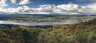
Hobart is the capital and most populous city of the Australian island state of Tasmania. Home to almost half of all Tasmanians, it is the least-populated Australian state capital city, and second-smallest if territories are taken into account, before Darwin, Northern Territory. Hobart is located in Tasmania's south-east on the estuary of the River Derwent, making it the most southern of Australia's capital cities. Its skyline is dominated by the 1,271-metre (4,170 ft) kunanyi/Mount Wellington, and its harbour forms the second-deepest natural port in the world, with much of the city's waterfront consisting of reclaimed land. The metropolitan area is often referred to as Greater Hobart, to differentiate it from the City of Hobart, one of the five local government areas that cover the city. It has a mild maritime climate.
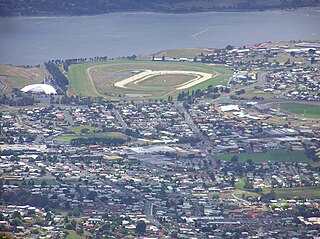
Glenorchy is a suburb of Hobart, in the state of Tasmania, Australia. Glenorchy is bound by the River Derwent to the east, Mount Wellington to the west, Hobart City to the south and Brighton to the north. The city officially begins at Creek Road New Town, in Hobart's northern suburbs, and includes, Moonah, Derwent Park, Lutana, Goodwood, Montrose, Rosetta, Berriedale, Chigwell, Claremont and Austins Ferry. It is the seat of the local government area of the same name, the City of Glenorchy.
Kingston is a town on the outskirts of Hobart, Tasmania, Australia. Nestled 12 km south of the city between and around several hills, Kingston is the seat of the Kingborough Council, and today serves as the gateway between Hobart and the D'Entrecasteaux Channel region, which meets the Derwent River nearby. It is one of the fastest-growing regions in Tasmania. The Kingston-Huntingfield statistical area had an estimated population of 11,200 in June 2012.

Bruny Island is a 362-square-kilometre (140 sq mi) island located off the south-eastern coast of Tasmania, Australia. The island is separated from the Tasmanian mainland by the D'Entrecasteaux Channel, and its east coast lies within the Tasman Sea. Storm Bay is located to the island's northeast. Both the island and the channel are named after French explorer, Antoine Bruni d'Entrecasteaux. Its traditional Aboriginal name is lunawanna-allonah, which survives as the name of two island settlements, Alonnah and Lunawanna.

Sorell is a town in Tasmania, Australia, north-east of Hobart. It is located on the Tasman Highway at the junction with the Arthur Highway. Sorell is one of Tasmania's oldest towns, being first settled in 1808 as a small farming community and becoming an official township in 1821. At the 2006 census, Sorell had a population of 1,546, and at the 2011 census, a population of 2,476. and at the 2016 census, a population of 2,907.

Huon Valley Council is a local government body in Tasmania, covering most of the south of the state. Huon Valley is classified as a rural local government area and has a population of 17,219, towns and localities of the region include Cygnet, Dover, Franklin, Geeveston, Southport and the largest principal town, Huonville.

Bicheno is a locality and town on the east coast of Tasmania, Australia, 185 km north-east of Hobart on the Tasman Highway, with a population of around 950. It is part of the municipality of Glamorgan-Spring Bay. The town is primarily a fishing port and a beach resort.

Sandy Bay is a suburb of the city of Hobart, Tasmania, Australia, located immediately south of the central business district, and adjoining the suburb of Battery Point. Sandy Bay is bounded on the east by the Derwent River, and has several beaches along the shore, the main beaches with public access are Short Beach, Nutgrove Beach, Long Beach and Lords Beach.

Ceduna is a town in South Australia located on the shores of Murat Bay on the west coast of Eyre Peninsula. It lies west of the junction of the Flinders and Eyre Highways around 786 km northwest of the capital Adelaide. The port town/suburb of Thevenard lies 3 km to the west on Cape Thevenard. It is in the District Council of Ceduna, the federal Division of Grey, and the state electoral district of Flinders.
Howrah is a residential locality in the local government area (LGA) of Clarence in the Hobart LGA region of Tasmania. The locality is about 5 kilometres (3.1 mi) south-east of the town of Rosny Park. The 2021 Census recorded a population of 9,545 for the state suburb of Howrah. It is a suburb of the City of Clarence. It is east of Bellerive and north of Tranmere.

Orford is a village on the east coast of Tasmania, Australia 73 kilometres north-east of Hobart. It is the home of the joint champions of T20 Cricket in Tasmania. The village is centred on the mouth of the Prosser River, on the southern margin of a substantial coastal inlet called Prosser Bay. Beyond this bay are the waters of the Mercury Passage. At the 2006 census, Orford had a population of 553.

Woodbridge is a semi-rural locality in the local government area (LGA) of Kingborough in the Hobart LGA region of Tasmania. The locality is about 26 kilometres (16 mi) south of the town of Kingston. The 2016 census has a population of 503 for the state suburb of Woodbridge. It is located 38 kilometres (24 mi) south of the state capital, Hobart.
Stanley is a town on the north-west coast of Tasmania, Australia. It is the second-last major township on the north-west coast when travelling west, Smithton being the larger township in the Circular Head municipality. According to the 2021 census, Stanley had a population of 595.
Dover is the southernmost town of its size in Australia, located on the western shores towards the southern end of the D'Entrecasteaux Channel, just south of the Huon Valley, southwest of Hobart, located on the head of Port Esperance in Tasmania. It has a population of 486; 91% were born in Australia and 5% was born in United Kingdom, with other less common origins such as New Zealand, Germany and Greece all clustering around the 1% mark.
Gagebrook is a residential locality in the local government area (LGA) of Brighton in the Hobart LGA region of Tasmania. The locality is about 9 kilometres (5.6 mi) south of the town of Brighton. The 2016 census recorded a population of 1440 for the state suburb of Gagebrook. It is one of the northernmost suburbs of Hobart, located near the eastern shore of the Derwent River between the suburbs of Bridgewater and Old Beach.
Brighton Council is a local government body in Tasmania, situated in the south-east of the state, north of Hobart. The Brighton local government area is classified as urban and has a population of 18,995, it is based in the town of Brighton but also covers the far northern Hobart suburbs of Bridgewater, Gagebrook, Honeywood and Old Beach.
Howden, a suburb of Hobart, is a small, relatively isolated community on the shore of North West Bay in Tasmania Australia. Situated between the developing township of Kingston and the smaller Margate, it borders bushland and is located 21 kilometres (13 mi) south of Hobart, the capital city of Tasmania.

Triabunna is a rural residential locality in the local government area (LGA) of Glamorgan–Spring Bay in the South-east LGA region of Tasmania. The locality is about 86 kilometres (53 mi) north-east of the city of Hobart. The 2021 census has a population of 905 for the state suburb of Triabunna.

Coles Bay is an Australian town on the east Coast of Tasmania 192 km north-east of Hobart and 173 km south-east of Launceston, being the main entrance point for visitors to the Freycinet National Park.
In the Australian state of Tasmania, there are many areas which are commonly known by regional names. Regions are areas that share similar characteristics. These characteristics may be natural such as the Furneaux Islands, the coastline, or the Central Highlands. Alternatively, the characteristics may be cultural, such as a viticulture land use. Tasmania is divided by numerous regional boundaries, based on different characteristics. In many cases boundaries defined by different government agencies are coterminous and are often cited by the Australian and local media that tend to distinguish between North West, West Coast, Southern, and East Coast.

