La Rioja, is the capital and largest city of La Rioja Province, Argentina, located in the east of the province.

San Fernando del Valle de Catamarca is the capital and largest city in Catamarca Province in northwestern Argentina, on the Río Valle River, at the feet of the Cerro Ambato. The city name is normally shortened as Catamarca.

Azul is the head city of the Azul Partido, located at the center of the Buenos Aires Province in Argentina, 300 km south of Buenos Aires. It has 63,000 inhabitants as per the 2001 census [INDEC].

Ezeiza is the capital city of the Ezeiza Partido within the Greater Buenos Aires area in Argentina. The city had a population of 160,219 in 2010. Ezeiza is one of the fastest-growing cities in Argentina; the city and its surroundings are known for the many gated communities there, as well as for the Ministro Pistarini International Airport and the Ezeiza Federal Prison Complex. Ezeiza and its surrounds are known as affluent areas.

Malargüe is a city in the southwest part of province of Mendoza, Argentina, about 370 km south of the provincial capital Mendoza. It is the head town of the Malargüe Department, and it has about 27,000 inhabitants as per the 2010 census [INDEC].
Pehuajó is a city in the Pehuajó Partido in the province of Buenos Aires, Argentina. The partido has about 38,400 inhabitants as per the 2001 census [INDEC]. The name of this relatively small city is well known in Argentina because of María Elena Walsh's song Manuelita, about an adventurous turtle (tortoise); a dilapidated concrete statue of María Elena Walsh's Manuelita lies just outside the city, beside Ruta Nacional 5.

San Fernando de la Buena Vista is a city in the Gran Buenos Aires area, in Argentina, and capital of the San Fernando Partido, 20 km (12 mi) north of the city of Buenos Aires.

Las Flores is a city in the province of Buenos Aires, Argentina, and the only city in Las Flores Partido. It had a population of about 26,000 at the 2022 census [INDEC]. It is located 187 km from Buenos Aires City. The main economic activities in the area are agriculture and cattle breeding.
Tinogasta is a city in the west of the province of Catamarca, Argentina, on the right-hand shore of the Abaucán River, about 280 km from the provincial capital San Fernando del Valle de Catamarca. It had about 11,500 inhabitants at the 2010 census [INDEC]. It is the head town of the department of the same name. The name of the city comes from the Kakana words tino ("meeting") and gasta ("town").
Monte Caseros is a city in the south-east of the province of Corrientes in the Argentine Mesopotamia. It has about 37,000 inhabitants as of the 2010 census [INDEC]. It is the head town of the department of the same name, which comprises also the municipalities of Colonia Libertad, Juan Pujol and Mocoretá.

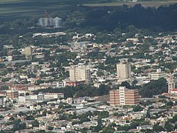
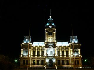
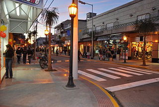
Olavarría is a city in the province of Buenos Aires, Argentina. It is the administrative seat of the Olavarría Partido and has over 111,320 inhabitants, per the 2010 census [INDEC].
Tres Arroyos is a city in Buenos Aires Province, Argentina. It is the administrative seat of Tres Arroyos Partido.
Laboulaye is a city in the southeast of the province of Córdoba, Argentina. It has 20,534 inhabitants as per the 2010 census [INDEC]. It lies on National Route 7, near the provincial borders of Santa Fe and Buenos Aires, about 315 km south from Córdoba City and 285 km west from Rosario.
Don Torcuato is a town in the Tigre Partido of the urban agglomeration of Greater Buenos Aires, Argentina. It is named after Marcelo Torcuato de Alvear, ex-President of Argentina, as he had his ranch and residency there. Most of the streets are named after his immediate family and his governmental staff.

San Miguel is a city in the northwest region of Greater Buenos Aires, 30 km from the City of Buenos Aires. San Miguel is the county seat of San Miguel Partido, and has been a part of Greater Buenos Aires since the early 2000s. The number of inhabitants was 157,532 according to the 2001 census.
Verónica is a town and localidad in Buenos Aires Province, in Argentina. It is the administrative centre for the county (partido) of Punta Indio.

San Martín is a city in the north-center part of the Mendoza Province in Argentina. It is the capital of the San Martín Department and constitutes, with Palmira and La Colonia, the third-largest metropolitan area in the province.

Villa Dolores is a city in the province of Córdoba, Argentina, located in the southwestern side of the province. It has a population of 29,854 inhabitants.
San Carlos de Bolívar is a town in Buenos Aires Province, Argentina. It is the administrative centre for Bolívar Partido.

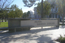
Dolores is a town in Buenos Aires Province, Argentina. It is the administrative centre for Dolores Partido. The town settlement was officially founded by Ramón Lara on 21 August 1817.