The Salween is a Southeast Asian river, about 3,289 kilometres (2,044 mi) long, flowing from the Tibetan Plateau south into the Andaman Sea. The Salween flows primarily within southwest China and eastern Myanmar (Burma), with a short section forming the border of Burma and Thailand. Throughout most of its course, it runs swiftly through rugged mountain canyons. Despite the river's great length, only the last 90 km (56 mi) are navigable, where it forms a modest estuary and delta at Mawlamyine. The river is known by various names along its course, including Thanlwin in Burma and Nu Jiang in China. The commonly used spelling "Salween" is an anglicisation of the Burmese name dating from 19th-century British maps.

The Tibetan Plateau, also known as the Qinghai–Tibet Plateau or the Qing–Zang Plateau or as the Himalayan Plateau in India, is a vast elevated plateau located at the intersection of Central, South and East Asia covering most of the Tibet Autonomous Region, most of Qinghai, western half of Sichuan, Southern Gansu provinces in Western China, southern Xinjiang, Bhutan, the Indian regions of Ladakh and Lahaul and Spiti as well as Gilgit-Baltistan in Pakistan, northwestern Nepal, eastern Tajikistan and southern Kyrgyzstan. It stretches approximately 1,000 kilometres (620 mi) north to south and 2,500 kilometres (1,600 mi) east to west. It is the world's highest and largest plateau above sea level, with an area of 2,500,000 square kilometres (970,000 sq mi). With an average elevation exceeding 4,500 metres (14,800 ft) and being surrounded by imposing mountain ranges that harbor the world's two highest summits, Mount Everest and K2, the Tibetan Plateau is often referred to as "the Roof of the World".
The Yun Range are a mountain range running north–south in northwestern Yunnan province, China. They were formerly romanized as the Yun Ling and tautologically as the Yun-ling Mountains. The Yun Range runs between the Lancang River (Mekong) to the west and Jinsha River (Yangtze) to the east. The range is a major component of the greater Hengduan Mountains.

Baoshan (help·info) is a prefecture-level city in Western Yunnan Province, People's Republic of China. Baoshan is the second-biggest metropolitan area in western Yunnan after Dali.
Zayul County (Tibetan: རྫ་ཡུལ་རྫོང, Wylie: rdza yul rdzong, THL: dza yül dzong) or Zayü County is a county in the Nyingchi Prefecture in the southeastern part of the Tibet Autonomous Region, China.

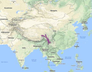
The Hengduan Mountains are a group of mountain ranges in southwest China that connect the southeast portions of the Tibetan Plateau with the Yunnan–Guizhou Plateau. The Hengduan Mountains are primarily large north-south mountain ranges that effectively separate lowlands in northern Myanmar from the lowlands of the Sichuan Basin. These ranges are characterized by significant vertical relief originating from the Indian subcontinent's collision with the Eurasian Plate, and further carved out by the major rivers draining the eastern Tibetan Plateau. These rivers, the Yangtze, Mekong, and Salween, are recognized today as the Three Parallel Rivers UNESCO World Heritage Site.
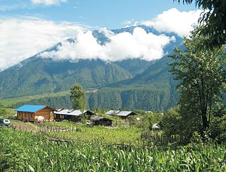
The Mountains of Southwest China is a biodiversity hotspot designated by Conservation International which includes several temperate coniferous forests in southwestern China, which lie in the river valleys on the southeastern corner of the Tibetan plateau, between the alpine scrublands and steppes of the Tibetan Plateau and the temperate broadleaf and mixed and subtropical moist broadleaf forests of central and southeastern China and northern Myanmar. The hotspot is mostly in China, in the provinces of Tibet, Sichuan, Qinghai, and Gansu, and extending into the northwestern Myanmar.
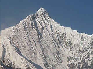
Kawa Garbo or Khawa Karpo, as it is known by local residents and pilgrims, or Kawagebo Peak, is the highest mountain in the Chinese province of Yunnan. It is located on the border between Dêqên County, Yunnan, and the counties of Zogang and Zayü of the Tibet Autonomous Region. It rises about 20 kilometres (12 mi) west of Shengping (升平镇), the seat of Dêqên County, which lies on China National Highway 214. What is now Dêqên County has been part of Yunnan since the 1720s, when the current border with Tibet was established by the early Qing Dynasty. Kawagarbo is one of the most sacred peaks in the Tibetan world and is often referred to as Nyainqênkawagarbo to show its sacredness and avoid ambiguousness with the other Kawagarbo in the Anung-Derung-speaking Gongshan County.

The black-and-white snub-nosed monkey, also known as the Yunnan snub-nosed monkey, is a large black and white primate that lives only in the southern Chinese province of Yunnan, where it is known to the locals as the Yunnan golden hair monkey (滇金丝猴) and the black-and-white snub-nosed monkey (黑白仰鼻猴). The common name, black snub-nosed monkey, is issued to Rhinopithecus strykeri, inhabiting the Northern Sino-Myanmar border. Coniferous and deciduous forests in the mountainous regions of Yunnan are the ideal terrain for these primates. It is threatened by habitat loss, and is considered an endangered species. With their unique adaptations to their environment, these monkeys thrive at extreme altitudes despite the below freezing temperatures and thin air. This primate's diet is mainly made up of the large amounts of lichens available in their region.

The Hengduan Mountains subalpine conifer forests are a temperate forest in the Hengduan Mountains of southwestern China. The forests extend within the Jinsha and Yalong River valleys from approximately 32°N to 27°N. In addition, a portion of the Anning River valley and Mianmian Mountains near Lugu Lake support the subalpine conifer forests. This region covers northern Yunnan Province, western Sichuan Province, and the extreme eastern edge of the Tibet Autonomous Region.

The Eastern Himalayan alpine shrub and meadows is a montane grasslands and shrublands ecoregion of Bhutan, China, India, Myanmar, and Nepal, which lies between the tree line and snow line in the eastern portion of the Himalaya Range.

The Three Parallel Rivers of Yunnan Protected Areas is a UNESCO World Heritage Site in Yunnan province, China. It lies within the drainage basins of the upper reaches of the Jinsha (Yangtze), Lancang (Mekong) and Nujiang (Salween) rivers, in the Yunnan section of the Hengduan Mountains.
Gongshan Derung and Nu Autonomous County is an autonomous county located in Nujiang Lisu Autonomous Prefecture, in the northwest of Yunnan province, China. It has an area of 4,506 km2 (1,740 sq mi) and a population of about 37,894 according to the 2010 Census. The county government is stationed in Cikai Town
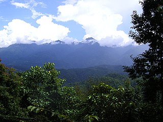
The Gaoligong Mountains are a mountainous sub-range of the southern Hengduan Mountain Range, located in the western Yunnan highlands and straddling the border of southwestern China and northern Myanmar (Burma).
The Northeastern Himalayan subalpine conifer forests are a temperate coniferous forests ecoregion of the middle to upper elevations of the eastern Himalayas and southeast Tibetan Plateau. The ecoregion occurs in southeastern Tibet Autonomous Region, China, in northern and eastern Arunachal Pradesh, India, and extreme eastern Bhutan.
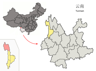
The Gaoligongshan National Nature Reserve (GNNR) is a protected area comprising the Gaoligong Mountains and the nearby Nu Jiang Reserve in the western Yunnan Province of China, near the international border with Burma. It covers a vast stretch of the junction of Baoshan City, Tengchong, and Lushui County, towards the west side of Nu (Salween) River.

The Northern Triangle subtropical forests ecoregion covers remote, mountainous terrain in the far north of Myanmar. Due to the regions isolation it is relatively untouched and unexplored by humans. Over 95% of the ecoregion is covered with closed evergreen forest, and importantly for conservation, these forests exist in large contiguous blocks. As of the late 1990s, 140 mammal species were known to be in the region, and new species, such the Leaf muntjac discovered in 1997, are still being found.
Emawbum National Park, also known as Imawbum National Park, is a national park in northern Myanmar. The park was designated in 2020, and covers an area of 603.4 km2. It is located in eastern Kachin State, and on the east it adjoins the border with China.