Akron–Canton Airport is a commercial airport in the city of Green, in southern Summit County, Ohio. The airport is located about 14 miles (23 km) southeast of Akron and 10 miles (16 km) northwest of Canton. It is jointly operated by Summit County and Stark County. The airport is a "reliever" airport for Northeast Ohio and markets itself as "A better way to go", emphasizing the ease of travel in comparison to Cleveland Hopkins International Airport. Just under 90% of its traffic is general aviation. It is included in the Federal Aviation Administration (FAA) National Plan of Integrated Airport Systems for 2019–2023, in which it is categorized as a small-hub primary commercial service facility.

West Michigan Regional Airport, formerly Tulip City Airport, is a public-use airport located two nautical miles (3.7 km) south of the central business district of Holland, a city in Ottawa County and Allegan County, Michigan, United States. It is included in the Federal Aviation Administration (FAA) National Plan of Integrated Airport Systems for 2017–2021, in which it is categorized as a national general aviation facility.

Ann Arbor Municipal Airport is a general aviation airport in Washtenaw County, Michigan, United States. It is included in the Federal Aviation Administration (FAA) National Plan of Integrated Airport Systems for 2017 to 2021, in which it is categorized as a regional general aviation facility.

Jackson County Airport, also known as Reynolds Field, is a county-owned, public-use airport located two nautical miles (3.7 km) west of the central business district of Jackson, in Jackson County, Michigan, United States. It is a class D airport with operating control tower. It is included in the Federal Aviation Administration (FAA) National Plan of Integrated Airport Systems for 2017–2021, in which it is categorized as a regional general aviation facility.
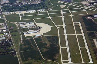
DuPage Airport is a general aviation airport located 29 miles (47 km) west of downtown Chicago in West Chicago, DuPage County, Illinois, United States. It is owned and operated by the DuPage Airport Authority, which is an independent government body established by law by the State of Illinois. It also serves as a relief airport for O'Hare International Airport and Chicago Midway International Airport, both in nearby Chicago.
Roben–Hood Airport is a public airport located two miles (3 km) northwest of the central business district of Big Rapids, a city in Mecosta County, Michigan, United States. It is owned by the City of Big Rapids. It is included in the Federal Aviation Administration (FAA) National Plan of Integrated Airport Systems for 2017–2021, in which it is categorized as a local general aviation facility.
Branch County Memorial Airport is a county-owned, public-use airport located three nautical miles (6 km) west of the central business district of Coldwater, a city in Branch County, Michigan, United States. It is included in the Federal Aviation Administration (FAA) National Plan of Integrated Airport Systems for 2017–2021, in which it is categorized as a local general aviation facility.
Frankfort Dow Memorial Field is a public use airport located two nautical miles (3.7 km) southeast of the central business district of Frankfort, a city in Benzie County, Michigan, United States. It is owned by the Frankfort City-County Airport Authority. It is included in the Federal Aviation Administration (FAA) National Plan of Integrated Airport Systems for 2017–2021, in which it is categorized as a general aviation facility.
Campbell Airport is a public-use airport located two miles (3 km) southwest of the central business district of Grayslake, a village in Lake County, Illinois, United States. It is privately owned by Kane Illinois Properties, Inc.
Romeo State Airport is a public airport owned and operated by the State of Michigan located 2 miles (3.2 km) east of Romeo, Michigan, United States. The airport is uncontrolled and is used for general aviation purposes. It is included in the Federal Aviation Administration (FAA) National Plan of Integrated Airport Systems for 2017–2021, in which it is categorized as a local reliever airport facility.
Dowagiac Municipal Airport is a public airport owned and operated by the City of Dowagiac located 1m (1.6 km) northwest of Dowagiac, Michigan, United States. The uncontrolled airport is used for general aviation purposes. It is included in the Federal Aviation Administration (FAA) National Plan of Integrated Airport Systems for 2017–2021, in which it is categorized as a local general aviation facility.
Lake County Executive Airport, formerly Lost Nation Airport, is a public use airport in Lake County, Ohio, United States. Located approximately 3 miles (5 km) north-northeast of the central business district of the City of Willoughby, it was owned and operated by that city until October 8, 2014, when it was transferred to Lake County and the Lake County Port and Economic Development Authority. The airport's name was changed from Lost Nation Airport to Lake County Executive Airport, alternately "Lake County Executive Airport at Lost Nation Field," in March 2020.
Medina Municipal Airport is a public use airport in Medina County, Ohio, United States. It is owned by the City of Medina and is located four nautical miles (7.41 km) east of the city's central business district. According to the FAA's National Plan of Integrated Airport Systems for 2007-2011, it is categorized as a reliever airport.
Paul C. Miller–Sparta Airport is a public airport located 3 mi (5 km) southeast of Sparta, Michigan. Established in 1941, the airport is currently owned and operated by the Village of Sparta and is self-supporting, requiring no public funding. It is included in the Federal Aviation Administration (FAA) National Plan of Integrated Airport Systems for 2017–2021, in which it is categorized as a regional general aviation facility.
Carroll County–Tolson Airport is a county–owned, public-use airport located one nautical mile (1.85 km) southeast of the central business district of Carrollton, a village in Carroll County, Ohio, United States. It is owned by the Carroll County Airport Authority. According to the FAA's National Plan of Integrated Airport Systems for 2009–2013, it is categorized as a general aviation airport.
Hastings Airport is a public use airport located three nautical miles (6 km) west of the central business district of Hastings, a city in Barry County, Michigan, United States. It is owned by the city and county and is also known as Hastings City/Barry County Airport.
Dalton Airport is a privately owned, public use airport located two nautical miles (4 km) east of the central business district of Flushing, in Genesee County, Michigan, United States. It is named after its founder, Edwin P. Dalton, who opened it in 1946 on the former site of the Marsa farm.
Greenville Municipal Airport is a city-owned, public-use airport located three nautical miles (6 km) south of the central business district of Greenville, a city in Montcalm County, Michigan, United States. It is included in the Federal Aviation Administration (FAA) National Plan of Integrated Airport Systems for 2017–2021, in which it is categorized as a local general aviation facility.
Pontiac Municipal Airport is a public use airport 3 miles north of Pontiac in Livingston County, Illinois. The airport is publicly owned by the City of Pontiac.
Weltzien Skypark is a privately owned, public use airport located 3 miles west of Wadsworth, Ohio in Medina County. The airpark sits on 26 acres at an elevation of 1210 feet.