Space-based radar is space-borne radar systems that may have any of a variety of purposes. A number of Earth-observing radar satellites, such as RADARSAT, have employed synthetic aperture radar (SAR) to obtain terrain and land-cover information about the Earth.
India's remote sensing program was developed with the idea of applying space technologies for the benefit of humankind and the development of the country. The program involved the development of three principal capabilities. The first was to design, build and launch satellites to a sun synchronous orbit. The second was to establish and operate ground stations for spacecraft control, data transfer along with data processing and archival. The third was to use the data obtained for various applications on the ground.

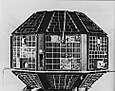
Cartosat-1 is a stereoscopic Earth observation satellite in a Sun-synchronous orbit, and the first one of the Cartosat series of satellites. The eleventh satellite of ISRO in Indian Remote Sensing Satellite (IRS) series. The satellite was built, launched and maintained by the Indian Space Research Organisation (ISRO). Weighing around 1560 kg at launch, its applications will mainly be towards cartography in India.
A scatterometer or diffusionmeter is a scientific instrument to measure the return of a beam of light or radar waves scattered by diffusion in a medium such as air. Diffusionmeters using visible light are found in airports or along roads to measure horizontal visibility. Radar scatterometers use radio or microwaves to determine the normalized radar cross section of a surface. They are often mounted on weather satellites to find wind speed and direction, and are used in industries to analyze the roughness of surfaces.
The NASA QuikSCAT was an Earth observation satellite carrying the SeaWinds scatterometer. Its primary mission was to measure the surface wind speed and direction over the ice-free global oceans. Observations from QuikSCAT had a wide array of applications, and contributed to climatological studies, weather forecasting, meteorology, oceanographic research, marine safety, commercial fishing, tracking large icebergs, and studies of land and sea ice, among others. This SeaWinds scatterometer is referred to as the QuikSCAT scatterometer to distinguish it from the nearly identical SeaWinds scatterometer flown on the ADEOS-2 satellite.
Cartosat-2 is an Earth observation satellite in a Sun-synchronous orbit and the second of the Cartosat series of satellites. The satellite was built, launched and maintained by the Indian Space Research Organisation (ISRO). Weighing around 680 kg at launch, its applications will mainly be towards cartography in India. It was launched by the Polar Satellite Launch Vehicle PSLC-C7 launch vehicle on 10 January 2007.
Cartosat-2A is an Earth observation satellite in a Sun-synchronous orbit and the third of the Cartosat series of satellites. The satellite is the thirteenth satellite in the Indian Remote Sensing (IRS) satellite series to be built, launched and maintained by the Indian Space Research Organisation (ISRO).

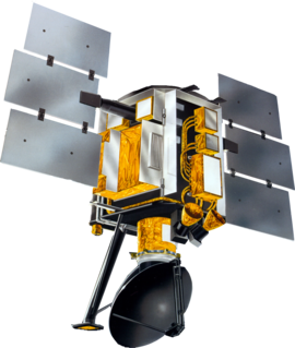
RISAT is a series of Indian radar imaging reconnaissance satellites built by ISRO. They provide all-weather surveillance using synthetic aperture radars (SAR).
Resourcesat-2 is a follow on mission to Resourcesat-1 and the eighteenth Indian remote sensing satellite built by Indian Space Research Organisation (ISRO). The new satellite provides the same services as the original Resourcesat-1, but was also designed to "provide data with enhanced multispectral and spatial coverage". Compared to Resourcesat-1, LISS-4 multispectral swath has been enhanced from 23 km to 70 km based on user needs. Suitable changes including miniaturization in payload electronics have been incorporated in Resourcesat-2.

SARAL is a cooperative altimetry technology mission of Indian Space Research Organisation (ISRO) and Centre National d'Études Spatiales (CNES). SARAL performs altimetric measurements designed to study ocean circulation and sea surface elevation.

The Cartosat satellites are a series of Indian optical earth observation satellites built and operated by the Indian Space Research Organisation (ISRO). The Cartosat series is a part of the Indian Remote Sensing Program. They are used for Earth's resource management, defence services and monitoring.
IRS-1E was an Earth observation mission launched under the National Natural Resources Management System (NNRMS) programme by Indian Space Research Organisation (ISRO). Sometimes written IRS-P1. The objective of the mission was to develop Earth imagery using instruments carried on board. Due to a malfunction of the launch vehicle, the satellite deviated from its path and plunged into the Indian Ocean.
Oceansat-1 or IRS-P4 was the first Indian satellite built primarily for ocean applications. It was a part of the Indian Remote Sensing Programme satellite series. The satellite carried an Ocean Colour Monitor (OCM) and a Multi-frequency Scanning Microwave Radiometer (MSMR) for oceanographic studies. Oceansat-1 thus vastly augment the IRS satellite system of Indian Space Research Organisation (ISRO) comprising four satellites, IRS-1B, IRS-1C, IRS-P3 and IRS-1D and extend remote sensing applications to several newer areas.
ScatSat-1 is a satellite providing weather forecasting, cyclone prediction, and tracking services to India. It has been developed by ISRO Satellite Centre, Bangalore whereas its payload was developed by Space Applications Centre, Ahmedabad. The satellite carries a Ku-band scatterometer similar to the Oceansat-2 which became dysfunctional after its life span of four-and-a-half years. India was dependent on NASA's ISS-RapidScat for prediction of cyclone forecasting and weather prediction. The data generated by this mini-satellite are used by National Aeronautics and Space Administration (NASA), European Organisation for the Exploitation of Meteorological Satellites (EUMETSAT) and National Oceanic and Atmospheric Administration (NOAA).
Cartosat-2E is an Earth observation satellite developed by the Indian Space Research Organisation (ISRO), and is the seventh in the Cartosat series. It is designed to collect high-resolution, large-scale imagery for use in urban planning, infrastructure development, utilities planning, and traffic management.

PSLV-C37 was the 39th mission of the Indian Polar Satellite Launch Vehicle (PSLV) program and its 16th mission in the XL configuration. PSLV-C37 successfully carried and deployed a record 104 satellites in sun-synchronous orbits. Launched on 15 February 2017 by the Indian Space Research Organisation (ISRO) from the Satish Dhawan Space Centre at Sriharikota, Andhra Pradesh. According to ISRO, the 101 international satellites were launched as part of a commercial arrangement between several firms and its commercial arm Antrix Corporation Limited, run under the auspices of the Indian Government's Department of Space.
PSLV-C38 was the 40th mission of the Indian Polar Satellite Launch Vehicle (PSLV) program and its 17th mission in the XL configuration. PSLV-C38 successfully carried and deployed 31 satellites in sun-synchronous orbits. It was launched on 23 June 2017 by the Indian Space Research Organisation (ISRO) from the Satish Dhawan Space Centre at Sriharikota, Andhra Pradesh.
Cartosat-2F is the eighth satellite in the Cartosat-2 Series. It is an Earth observation satellite launched on the PSLV-C40 mission by the Indian Space Research Organisation (ISRO).

RISAT-2BR1 is a synthetic-aperture radar (SAR) imaging satellite built by Indian Space Research Organisation (ISRO). It is part of India's RISAT series of SAR imaging satellite and fourth satellite in the series. RISAT-2BR1 was launched on 11 December 2019 at 09:55 UTC aboard Polar Satellite Launch Vehicle PSLV-C48 from First Launch Pad (FLP) of Satish Dhawan Space Centre. It was the 50th launch of Polar Satellite Launch Vehicle and 75th launch from Satish Dhawan Space Centre.
Oceansat is a series of earth observation satellites built, launched, and operated by Indian Space Research Organisation, and dedicated to oceanography and atmospheric studies. Oceansat satellites facilitate a range of applications including documenting chlorophyll concentration, phytoplankton blooms, atmospheric aerosols and particulate matter. as well as marine weather forecast to predict cyclones.