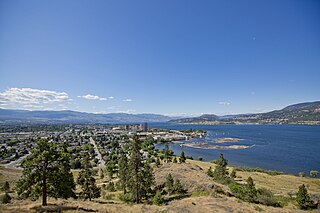
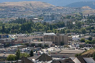
Kelowna is a city on Okanagan Lake in the Okanagan Valley in the southern interior of British Columbia, Canada. It serves as the head office of the Regional District of Central Okanagan. The name Kelowna derives from the Okanagan word kiʔláwnaʔ, referring to a male grizzly bear.
Vernon is a city in the Okanagan region of the Southern Interior of British Columbia, Canada. It is 440 km (270 mi) northeast of Vancouver. Named after Forbes George Vernon, a former MLA of British Columbia who helped establish the Coldstream Ranch in nearby Coldstream, the City of Vernon was incorporated on December 30, 1892. The City of Vernon has a population of 40,000 (2013), while its metropolitan region, Greater Vernon, has a population of 58,584 as of the Canada 2011 Census. With this population, Vernon is the largest city in the North Okanagan Regional District. A resident of Vernon is called a "Vernonite".
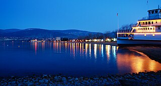
Penticton is a city in the Okanagan Valley of the Southern Interior of British Columbia, Canada, situated between Okanagan and Skaha lakes. In the 2016 Canadian Census, its population was 33,761, while its census agglomeration population was 43,432.

Okanagan Lake is a lake in the Okanagan Valley of British Columbia, Canada. The lake is 135 km (84 mi) long, between 4 and 5 km wide, and has a surface area of 348 km2.

The Okanagan, also known as the Okanagan Valley and sometimes as the Okanagan Country, is a region in the Canadian province of British Columbia defined by the basin of Okanagan Lake and the Canadian portion of the Okanagan River. It is part of the Okanagan Country, extending into the United States as Okanogan County in north-central Washington. According to the 2016 Canadian census, the region's population is 362,258. The largest populated cities are Kelowna, Penticton, Vernon, and West Kelowna.

Osoyoos is the southernmost town in the Okanagan Valley in British Columbia between Penticton and Omak. The town is 3.6 km (2.2 mi) north of the United States border with Washington state and is adjacent to the Osoyoos Indian reserve. The origin of the name Osoyoos was the word sw̓iw̓s meaning "narrowing of the waters" in the local Okanagan language (Syilx'tsn). The "O-" prefix is not indigenous in origin and was attached by settler-promoters wanting to harmonize the name with other place names beginning with O in the Okanagan region. There is one local newspaper, the Osoyoos Times.

Oliver is a town near the south end of the Okanagan Valley in the Southern Interior of British Columbia, Canada, with a population of nearly 5,000 people. It is located along the Okanagan River by Tuc-el-nuit Lake between Osoyoos and Okanagan Falls, and is labeled as the Wine Capital of Canada by Tourism British Columbia. It was once "The Home of the Cantaloupe" as well as the "Home of the International Horseshow."

Summerland is a town on the west side of Okanagan Lake in the interior of British Columbia, Canada. The district is between Peachland to the north and Penticton to the south. The largest centre in the region is Kelowna, approximately 50 km (31 mi) to the north, and Vancouver is approximately 425 km (264 mi) away to the west. The district is famous for "Bottleneck drive", a system of roads connecting various wineries.

The Regional District of Central Okanagan (RDCO) is a regional district in the Canadian province of British Columbia, comprising the City of Kelowna, City of West Kelowna and their surrounding municipalities. The regional district's offices are located in Kelowna.

Naramata is an unincorporated community in the Okanagan region of south central British Columbia. On the eastern shore of southern Lake Okanagan, the locality is by road about 15 kilometres (9 mi) north of Penticton.

Lake Country is a district municipality with a population of approximately 15,000 in the Okanagan Valley region of British Columbia, Canada. It is a part of the Central Okanagan Regional District, and of the Kelowna metropolitan area. The city of Kelowna lies to the south, while the city of Vernon lies to the north. As its name suggests, there are a number of lakes in the vicinity of Lake Country, and outside the municipal boundaries in the hills to the east. Okanagan Lake defines the western boundary of the municipality, while the entirety of Wood Lake and the southernmost portion of Kalamalka Lake are encompassed by it.
Winfield is a neighbourhood and formal ward within the District Municipality of Lake Country, British Columbia, located adjacent to the northern city boundary of Kelowna.
The Boundary Country is a historical designation for a district in southern British Columbia lying, as its name suggests, along the boundary between Canada and the United States. It lies to the east of the southern Okanagan Valley and to the west of the West Kootenay. It is often included in descriptions of both of those regions but historically has been considered a separate region. Originally inclusive of the South Okanagan towns of Osoyoos and Oliver, today the term continues in use to refer to the valleys of the Kettle, West Kettle, and Granby Rivers and of Boundary and Rock Creeks and that of Christina Lake and of their various tributaries, all draining the south slope of the Monashee Mountains The term Boundary District as well as the term Boundary Country can both refer to the local mining division of the British Columbia Ministry of Mines, Energy and Petroleum Resources.

The Okanagan Country, also known as the Okanagan Valley, is a region located in the Canadian province of British Columbia and the U.S. state of Washington, defined by the basin of Okanagan Lake and the Okanagan River. With an estimated 400,000 residents, the Okanagan Country spans from the Thompson Plateau near Grindrod, British Columbia in the Okanagan to the Okanagan Highland near Douglas County, Washington in the Okanogan. The largest city in the Canadian portion is Kelowna, with a metropolitan population of 194,882 residents as of 2016, while the largest city in the American portion is Omak, with 4,881 residents as of 2011. The region took its current name in honor of the Okanagan term, ukʷnaqín. The mild climate and close proximity to lakes, rivers and mountainous regions make the Okanagan Country an outdoor recreational destination. The region's economy is dominated by the primary sector industries of agriculture and forestry, although economic diversification has also occurred with retirement communities and recreational tourism. The American portion is considered to be more remote than the Canadian division, with approximately 10 percent of the population.

The Okanagan Valley wine region, located within the region of the same name in the British Columbia Interior, is Canada's second-largest wine producing area. Along with the nearby Similkameen Valley, the approximately 8,619 acres of vineyards planted in the Okanagan account for more than 80% of all wine produced in British Columbia, and are second in economic importance for wine production to the Niagara Peninsula of Ontario. Some 182 licensed wineries existed from south to north in the valley in 2018, with many situated along the 135 km (84 mi)-long Okanagan Lake and its tributaries and downstream lakes, including Skaha Lake, Vaseux Lake, and Osoyoos Lake. The Okanagan has diverse terrain that features many different microclimates and vineyard soil types, contributing characteristics which are part of an Okanagan terroir.

Oyama is a neighbourhood and formal ward located within the district municipality of Lake Country, which is located in the Okanagan region in British Columbia, Canada. It is located at the north end of Wood Lake and at the south end of Kalamalka Lake opposite BC Highway 97.

Carr's Landing, officially Carrs, is a neighbourhood and formal ward in District Municipality of Lake Country, which is located in the Okanagan region of British Columbia, Canada.
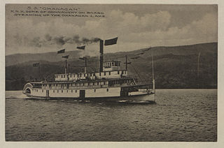
SS Okanagan was a steamship owned and operated by the Canadian Pacific Railway Lake and River Service. The vessel was constructed in 1906 at Okanagan Landing and launched in 1907, becoming Okanagan Lake's second steamship. She linked the transportation hubs at both the north and south ends of Okanagan Lake (Vernon and Penticton, respectively, aiding the development of interior British Columbia with other steamships of the 1900s. The ship was retired in 1934 and sold for scrap and spare parts. Only the Stern Saloon, a room in the back of the upper deck, remains. It was moved to the SS Sicamous Heritage Park in Penticton in 2002, to undergo restoration work.

SS Aberdeen was a steamship commissioned by Canadian Pacific Railway company. It was the first CPR steamship on Okanagan Lake and carried passengers and cargo from Okanagan Landing to Penticton from 1893 to 1919. Aberdeen connected communities along Okanagan Lake for the first time, creating a new era in the Okanagan Valley and greatly aiding the economy and settlement of the interior of British Columbia.

Kuskanook was a wooden, stern-wheel driven steamboat that operated on Kootenay Lake, in British Columbia from 1906 to 1931. After being taken out of service, Kuskanook was sold for use as a floating hotel, finally sinking in 1936. The vessel name is also seen spelled Kooskanook.
