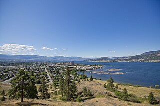
Rutland is Kelowna's largest neighbourhood by far. Rutland has a population of 34, 800 and the median age is 39.2.[3] The neighbourhood is mostly residential, but also has a thriving business community and Kelowna City council is working with community groups to make plans for revitalisation of Rutland Town Centre.
History
Rutland was an unincorporated town until it was forced to merge with the nearby city of Kelowna in 1973[4] by an act of the provincial legislature.
Rutland is named for an early settler, John "Hope" Matthew Rutland. Rutland, who had previously lived at Australian, near Quesnel, farmed wheat, planted the first commercial orchards, and installed the first large irrigation system in the area. In the 1900s he sold his land to a syndicate which subdivided the land and adjacent land and named the district after him.[1] The post office was opened on October 1, 1908.[5]
Kelowna is a city on Okanagan Lake in the Okanagan Valley in the southern interior of British Columbia, Canada. It serves as the head office of the Regional District of Central Okanagan. The name Kelowna derives from the Okanagan word kiʔláwnaʔ, referring to a grizzly bear.
New Westminster is a city in the Lower Mainland region of British Columbia, Canada, and a member municipality of the Metro Vancouver Regional District. It was founded by Major-General Richard Moody as the capital of the Colony of British Columbia in 1858 and continued in that role until the Mainland and Island colonies were merged in 1866. It was the British Columbia Mainland's largest city from that year until it was passed in population by Vancouver during the first decade of the 20th century.
Fort St. John is a city located in northeastern British Columbia, Canada. The most populous municipality in the Peace River Regional District, the city encompasses a total area of about 22 km2 (8.5 sq mi) with 21,465 residents recorded in the 2021 Census. Located at Mile 47 of the Alaska Highway, it is one of the largest cities between Dawson Creek, British Columbia and Delta Junction, Alaska. Established in 1794 as a trading post, Fort St. John is the oldest European-established settlement in present-day British Columbia. The city is served by the Fort St. John Airport. The municipal slogan is Fort St. John: The Energetic City.
The Okanagan, also called the Okanagan Valley and sometimes the Okanagan Country, is a region in the Canadian province of British Columbia defined by the basin of Okanagan Lake and the Canadian portion of the Okanagan River. It is part of the Okanagan Country, extending into the United States as Okanogan County in north-central Washington. According to the 2016 Canadian census, the region's population is 362,258. The largest populated cities are Kelowna, Penticton, Vernon, and West Kelowna.
Highway 97 is a major highway in the Canadian province of British Columbia. It is the longest continuously numbered route in the province, running 2,081 km (1,293 mi) and is the only route that runs the entire north–south length of the British Columbia, connecting the Canada–United States border near Osoyoos in the south to the British Columbia–Yukon boundary in the north at Watson Lake, Yukon.
The Regional District of Central Okanagan (RDCO) is a regional district in the Canadian province of British Columbia, representing two unincorporated Electoral Areas of Central Okanagan East and Central Okanagan West, along with the member municipalities of the City of Kelowna, City of West Kelowna, the District of Lake Country, the District of Peachland, and Westbank First Nation. The RDCO office is located in Kelowna.
Westbank is one of the communities within the City of West Kelowna in the province of British Columbia. It is 12 km to the west of Kelowna. Other communities in West Kelowna include Casa Loma, West Kelowna Estates, Shannon Lake, Smith Creek, Glenrosa, Rose Valley and Lakeview Heights. Westbank sits to the south of West Kelowna.
Lake Country is a district municipality with a population of approximately 15,000 in the Okanagan Valley region of British Columbia, Canada. It is a part of the Central Okanagan Regional District, and of the Kelowna metropolitan area. The city of Kelowna lies to the south, while the city of Vernon lies to the north. As its name suggests, there are a number of lakes in the vicinity of Lake Country, and outside the municipal boundaries in the hills to the east. Okanagan Lake defines the western boundary of the municipality, while the entirety of Wood Lake and the southernmost portion of Kalamalka Lake are encompassed by it.
Chase is a village located in the Interior of British Columbia, Canada. It has a population of 2,399, and its main industries are forestry and tourism. It is located at the outlet of Little Shuswap Lake, which is the source of the South Thompson River. Chase Creek, which drops over three small waterfalls before flowing through the town, enters the South Thompson just below the lake's outlet.
Mount Boucherie is a mountain located in West Kelowna on the west shore of Okanagan Lake, British Columbia, Canada, opposite the city of Kelowna. It is the remnants of a former stratovolcano created nearly 60 million years ago. Between four and six different glacial periods over the past 50 million years have eroded the volcano to produce Mount Boucherie. Though it now only rises 417 metres above the nearby lake level, it is estimated to once have had an elevation of 2,000 m (6,562 ft) or more.
West Kelowna, formerly known as Westside and colloquially known as Westbank, is a city in British Columbia's Okanagan Valley on the west shore of Okanagan Lake. The city encompasses several neighbourhoods, including Casa Loma, Gellatly, Glenrosa, Lakeview Heights, Shannon Lake, Smith Creek, Rose Valley, Westbank, and West Kelowna Estates. As of 2021, West Kelowna had an estimated population of 36,078.
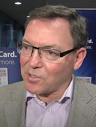
Norm Letnick is a Canadian politician, who was first elected as a member of the Legislative Assembly of British Columbia in the 2009 provincial election and re-elected in 2013, 2017, and 2020. During his terms in office, Letnick served over four years as British Columbia's minister of Agriculture, the longest period in this portfolio of any BC Liberal. He was elected as a member of the BC Liberal Party in the riding of Kelowna-Lake Country. While his party formed a majority government in the 39th Parliament, Letnick was not initially included in the cabinet but was appointed to several committees, including the Select Standing Committee on Health where he was chair and tasked to report on the impacts of baby boomers and alternative strategies on the health care system. Prior to being appointed assistant deputy speaker he served as opposition health critic for three years. During that time he worked in close collaboration with health minister Adrian Dix on many files but none more important than the 2020 Covid-19 pandemic response.
Benjamin Richard Stewart is a Canadian politician, who has represented the riding of Kelowna West in the Legislative Assembly of British Columbia since 2018 as a member of the British Columbia Liberal Party. He previously represented the riding of Westside-Kelowna from 2009 to 2013.
Kelowna Regional Transit System is operated by FirstCanada, providing public bus transportation services in part of the central Okanagan Valley of British Columbia, Canada. Funding for the transit system is shared between the City of Kelowna, Regional District of Central Okanagan, District of Lake Country, City of West Kelowna, Westbank First Nation and BC Transit, while the planning and routing decisions are primarily made by Kelowna City Council. Kelowna Regional Transit was one of the first public transit systems in Canada to have double-decker buses, and the first in Canada to have hybrid buses on regular routes. The hybrid and double deckers buses have since been relocated to Victoria.
The history of Chinese Canadians in British Columbia began with the first recorded visit by Chinese people to North America in 1788. Some 30–40 men were employed as shipwrights at Nootka Sound in what is now British Columbia, to build the first European-type vessel in the Pacific Northwest, named the North West America. Large-scale immigration of Chinese began seventy years later with the advent of the Fraser Canyon Gold Rush of 1858. During the gold rush, settlements of Chinese grew in Victoria and New Westminster and the "capital of the Cariboo" Barkerville and numerous other towns, as well as throughout the colony's interior, where many communities were dominantly Chinese. In the 1880s, Chinese labour was contracted to build the Canadian Pacific Railway. Following this, many Chinese began to move eastward, establishing Chinatowns in several of the larger Canadian cities.
This page is based on this Wikipedia article Text is available under the CC BY-SA 4.0 license; additional terms may apply. Images, videos and audio are available under their respective licenses.


