Okfuskee County, Oklahoma

Last updated

Okfuskee County
Okfuskee County Courthouse 1.jpg
Okfuskee County Courthouse
Map of Oklahoma highlighting Okfuskee County.svg
Location within the U.S. state of Oklahoma
Oklahoma in United States.svg
Oklahoma's location within the U.S.
Coordinates: 35°28′N96°20′W / 35.47°N 96.33°W / 35.47; -96.33
CountryFlag of the United States.svg United States
StateFlag of Oklahoma.svg  Oklahoma
Founded1907
Seat Okemah
Largest cityOkemah
Area
  Total629 sq mi (1,630 km2)
  Land619 sq mi (1,600 km2)
  Water10 sq mi (30 km2)  1.6%
Population
 (2020)
  Total11,310
  Density18/sq mi (6.9/km2)
Congressional district 2nd

Okfuskee County is a county located in the U.S. state of Oklahoma. As of the 2020 census, its population was 11,310. [1] Its county seat is Okemah. [2] The county is named for a former Muscogee town in present Cleburne County, Alabama, that in turn was named for the Okfuskee, a Muscogee tribe.

Contents

History

West Broadway Street in Okemah West Broadway Street, Okemah, March 2010.jpg
West Broadway Street in Okemah

The area now covered by Okfuskee County was occupied by the Quapaw and Osage tribes until 1825, when they ceded the land to the United States government. The Creeks moved here in the early 1830s and built two towns, Greenleaf and Thlopthlocco. During the Civil War, Thlopthlocco served as headquarters for Confederate Col. Douglas H. Cooper. Greenleaf was where Chief Opothleyahola camped while he tried to retain unity among the Creeks, before leading over 5000 Creeks to Kansas to avoid the war. [3]

After the war, the Creeks were required to free their African American slaves. Many of these people remained in the same area and founded all-black communities. These towns included Boley, Bookertee, Clearview, Chilesville, and Rusk. Okfuskee, a Creek town, grew up around Samuel Checote's trading post after the Civil War. [3]

The St. Louis and San Francisco Railway built a north–south line through this area during 1901–03. The Fort Smith and Western Railroad constructed an east–west line in 1903. [3]

Okfuskee County was created at statehood from the former Creek Nation, and Okemah was designated as the county seat. Oil and gas production began in the county in 1914, when the Prairie Oil and Gas Company completed a well near Paden. Other wells followed elsewhere in the county, creating a population boom that peaked in 1930. [3]

Geography

According to the U.S. Census Bureau, the county has a total area of 629 square miles (1,630 km2), of which 619 square miles (1,600 km2) are land and 10 square miles (26 km2) (1.6%) are covered by water. [4] The county lies within the Sandstone Hills physiographic region. The northeastern part is drained by the Deep Fork of the Canadian River, while the southern part is drained by the North Canadian River. [3]

Major highways

Adjacent counties

Demographics

Historical population
CensusPop.Note
1910 19,995
1920 25,05125.3%
1930 29,01615.8%
1940 26,279−9.4%
1950 16,948−35.5%
1960 11,706−30.9%
1970 10,683−8.7%
1980 11,1254.1%
1990 11,5513.8%
2000 11,8142.3%
2010 12,1913.2%
2020 11,310−7.2%
U.S. Decennial Census [5]
1790-1960 [6] 1900-1990 [7]
1990-2000 [8] 2010 [9]
Age pyramid for Okfuskee County, Oklahoma, based on census 2000 data. USA Okfuskee County, Oklahoma age pyramid.svg
Age pyramid for Okfuskee County, Oklahoma, based on census 2000 data.

As of the 2010 United States Census, there were 12,191 people living in the county. 64.4% were White, 19.7% Native American, 8.3% Black or African American, 0.2% Asian, 0.1% Pacific Islander, 0.8% of some other race and 6.5% of two or more races. 2.9% were Hispanic or Latino (of any race).

As of the census [10] of 2000, there were 11,814 people, 4,270 households, and 2,971 families living in the county. The population density was 7/km2 (18/sq mi). There were 5,114 housing units at an average density of 3/km2 (7.8/sq mi). The racial makeup of the county was 65.46% White, 10.41% Black or African American, 18.20% Native American, 0.08% Asian, 0.57% from other races, and 5.27% from two or more races. 1.64% of the population were Hispanic or Latino of any race. 92.5% spoke English, 3.5% Muskogee, 2.1% Spanish and 1.3% German as their first language.

There were 4,270 households, out of which 29.20% had children under the age of 18 living with them, 54.10% were married couples living together, 11.20% had a female householder with no husband present, and 30.40% were non-families. 27.80% of all households were made up of individuals, and 14.50% had someone living alone who was 65 years of age or older. The average household size was 2.52 and the average family size was 3.06.

In the county, the population was spread out, with 24.60% under the age of 18, 8.20% from 18 to 24, 26.70% from 25 to 44, 24.20% from 45 to 64, and 16.30% who were 65 years of age or older. The median age was 39 years. For every 100 females there were 106.50 males. For every 100 females age 18 and over, there were 107.90 males.

The median income for a household in the county was $24,324, and the median income for a family was $30,325. Males had a median income of $24,129 versus $17,819 for females. The per capita income for the county was $12,746. About 17.30% of families and 23.00% of the population were below the poverty line, including 29.60% of those under age 18 and 17.50% of those age 65 or over.

Life expectancy and health

Of 3,142 counties in the United States in 2014, the Institute for Health Metrics and Evaluation ranked Okfuskee County 2,986 in the life expectancy at birth of male residents and 3,091 in the life expectancy of female residents. Males in Okfuskee County lived an average of 70.8 years and females lived an average of 75.7 years compared to the national life expectancy of 76.7 for males and 81.5 for females. [11] In the 1980-2014 period, the average life expectancy in Okfuskee County for females decreased by 1.3 years while male longevity increased by 1.9 years compared to the national average for the same period of an increased life expectancy of 4.0 years for women and 6.7 years for men. Okfuskee was one of only a few counties in the United States to suffer a decline in life expectancy for women between 1980 and 2014. [12]

In 2020, the Robert Wood Johnson Foundation ranked Okfuskee country as number 73 of 77 counties in Oklahoma in "health outcomes," as measured by length and quality of life. [13]

Politics

Voter Registration and Party Enrollment as of June 30, 2023 [14]
PartyNumber of VotersPercentage
Democratic 2,09335.29%
Republican 2,95749.86%
Unaffiliated88114.85%
Total5,931100%
United States presidential election results for Okfuskee County, Oklahoma [15]
Year Republican Democratic Third party
No.%No.%No.%
2020 3,05875.73%89622.19%842.08%
2016 2,80071.01%94323.92%2005.07%
2012 2,33565.02%1,25634.98%00.00%
2008 2,64364.10%1,48035.90%00.00%
2004 2,54259.32%1,74340.68%00.00%
2000 1,91050.42%1,81447.89%641.69%
1996 1,38034.41%2,07451.72%55613.87%
1992 1,58034.13%2,14146.24%90919.63%
1988 1,85145.17%2,20953.90%380.93%
1984 2,44358.94%1,68440.63%180.43%
1980 2,12648.31%2,17749.47%982.23%
1976 1,63037.69%2,66361.57%320.74%
1972 2,86266.73%1,32830.96%992.31%
1968 1,68637.94%1,77739.99%98122.07%
1964 1,62935.93%2,90564.07%00.00%
1960 2,51056.05%1,96843.95%00.00%
1956 2,29949.65%2,33150.35%00.00%
1952 2,46947.08%2,77552.92%00.00%
1948 1,62432.75%3,33567.25%00.00%
1944 2,17739.75%3,29160.09%90.16%
1940 3,00139.49%4,57460.19%240.32%
1936 2,16230.66%4,84368.68%470.67%
1932 1,41521.63%5,12678.37%00.00%
1928 3,61258.25%2,51340.53%761.23%
1924 1,43132.90%2,65461.03%2646.07%
1920 1,76048.19%1,65045.18%2426.63%
1916 67026.46%1,33752.80%52520.73%
1912 65127.78%95240.63%74031.58%

Communities

NRHP sites

The following sites in Okfuskee County are listed on the National Register of Historic Places:

Okfuskee was the home county of American folk icon Woody Guthrie, who was born in Okemah. Guthrie refers to Okfuskee in one of his lost lyrics, "Way Over Yonder In the Minor Key." The lyrics were set to music by Billy Bragg and Wilco for their 1998 collaboration, Mermaid Avenue .

See also

Related Research Articles

<span class="mw-page-title-main">Seminole County, Oklahoma</span> County in Oklahoma, United States

Seminole County is a county located in the U.S. state of Oklahoma. As of the 2020 census, the population was 23,556. Its county seat is Wewoka. Most of the county was a reservation for the Seminole Nation of Oklahoma which still retains jurisdiction over some land in the county. A small portion of land at the eastern end of the county belonged to the Muscogee (Creek) Nation.

<span class="mw-page-title-main">Pottawatomie County, Oklahoma</span> County in Oklahoma, United States

Pottawatomie County is a county located in the U.S. state of Oklahoma. As of the 2020 census, the population was 72,454. Its county seat is Shawnee.

<span class="mw-page-title-main">Okmulgee County, Oklahoma</span> County in Oklahoma, United States

Okmulgee County is a county in the U.S. state of Oklahoma. As of the 2020 census, the population was 36,706. The county seat is Okmulgee. Located within the Muscogee Nation Reservation, the county was created at statehood in 1907. The name Okmulgee is derived from the Hitchita word okimulgi, meaning "boiling waters".

<span class="mw-page-title-main">Lincoln County, Oklahoma</span> County in Oklahoma, United States

Lincoln County is a county in eastern Central Oklahoma. As of the 2020 census, the population was 33,458. Its county seat is Chandler.

<span class="mw-page-title-main">Kay County, Oklahoma</span> County in Oklahoma, United States

Kay County is a county located in the U.S. state of Oklahoma. As of the 2020 census, its population was 43,700. Its county seat is Newkirk, and the largest city is Ponca City.

<span class="mw-page-title-main">Hughes County, Oklahoma</span> County in Oklahoma, United States

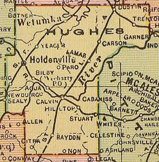
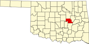
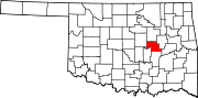
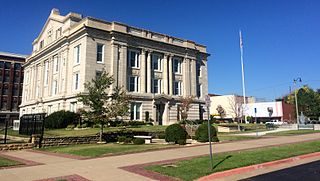
Hughes County is a county located in south central U.S. state of Oklahoma. As of the 2020 census, the population was 13,367. Its county seat is Holdenville. The county was named for W. C. Hughes, an Oklahoma City lawyer who was a member of the Oklahoma Constitutional Convention.

<span class="mw-page-title-main">Creek County, Oklahoma</span> County in Oklahoma, United States

Creek County is a county located in the U.S. state of Oklahoma. As of the 2020 census, the population was 71,754. Its county seat is Sapulpa.

<span class="mw-page-title-main">Choctaw County, Oklahoma</span> County in Oklahoma, United States

Choctaw County is a county located in the U.S. state of Oklahoma. As of the 2020 census, the population was 14,204. Its county seat is Hugo.

<span class="mw-page-title-main">Whitesburg, Georgia</span> Town in Georgia, United States

Whitesburg is a town in Carroll County, Georgia, United States. The population was 588 at the 2010 census.

<span class="mw-page-title-main">Rentiesville, Oklahoma</span> Town in Oklahoma, United States

Rentiesville is a town in McIntosh County, Oklahoma, United States. It was founded in 1903 and named for William Rentie, a local landowner. It was one of 50 all-black towns in Oklahoma and one of 13 that still survives. The population was 128 at the 2010 census, an increase of 25.5 percent from 102 in 2000.

<span class="mw-page-title-main">Taft, Oklahoma</span> Town in Oklahoma, United States

Taft is a town in Muskogee County, Oklahoma, United States. The population was 250 at the 2010 census, a decline of 28.4 percent from the figure of 349 recorded in 2000. The town began as an all-black town on land allotted to Creek Freedmen. It is named for President William Howard Taft.

<span class="mw-page-title-main">Bearden, Oklahoma</span> Town in Oklahoma, United States

Bearden is a town in Okfuskee County, Oklahoma, United States. The population was 135 at the 2020 Census.

<span class="mw-page-title-main">Boley, Oklahoma</span> Town in Oklahoma, United States

Boley is a town in Okfuskee County, Oklahoma, United States. The population was 1,091 at the 2020 Census. Boley was incorporated in 1905 as a predominantly Black pioneer town with persons having Native American ancestry among its citizens. Boley is currently home to barbeque equipment maker, Smokaroma, Inc, and the John Lilley Correctional Center.

<span class="mw-page-title-main">Castle, Oklahoma</span> Town in Oklahoma, United States

Castle is a town in Okfuskee County, Oklahoma, United States. A post office was established February 25, 1903, and the town was named for the first postmaster, Manford B. Castle. The population was 169 at the 2020 Census.

<span class="mw-page-title-main">Clearview, Oklahoma</span> Town in Oklahoma, United States

Clearview is a town in Okfuskee County, Oklahoma, United States. The population was 41 at the 2020 Census. It was historically an all-black freedmen's town and was platted by the Lincoln Townsite Company and designated as Lincoln.

<span class="mw-page-title-main">Okemah, Oklahoma</span> City in Oklahoma, United States

Okemah is the largest city in and the county seat of Okfuskee County, Oklahoma, United States. It is the birthplace of folk music legend Woody Guthrie. Thlopthlocco Tribal Town, a federally recognized Muscogee Indian tribe, is headquartered in Okemah. The population was 3,078 at the 2020 census, a 6.1 percent decline from 3,223 at the 2010 census.

<span class="mw-page-title-main">Paden, Oklahoma</span> Town in Oklahoma, United States

Paden is a town in Okfuskee County, Oklahoma, United States. The population was 419 at the 2020 Census. It is named for Paden Tolbert, a U.S. Deputy Marshal who served the area in the early 1900s.

<span class="mw-page-title-main">Weleetka, Oklahoma</span> Town in Oklahoma, United States

Weleetka is a town in Okfuskee County, Oklahoma, United States. It is approximately 10 miles (16 km) southeast of Okemah, the county seat. The name is a Creek word meaning "running water." The population was 806 at the time of the 2020 census.

<span class="mw-page-title-main">Grayson, Oklahoma</span> Town in Oklahoma, United States

Grayson is a town in Okmulgee County, Oklahoma, United States. The population was 127 at the 2020 census.

<span class="mw-page-title-main">Thlopthlocco Tribal Town</span>

Thlopthlocco Tribal Town is both a federally recognized Native American tribe and a traditional township of Muscogee Creek Indians, based in Oklahoma. The tribe's native language is Mvskoke, also called Creek.

References

  1. "Okfushkee County, Oklahoma". United States Census Bureau . Retrieved May 20, 2023.
  2. "Find a County". National Association of Counties. Archived from the original on May 31, 2011. Retrieved June 7, 2011.
  3. 1 2 3 4 5 Linda D. Wilson, "Okfuskee County." Encyclopedia of Oklahoma History and Culture. Retrieved August 18, 2013.
  4. "2010 Census Gazetteer Files". United States Census Bureau. August 22, 2012. Retrieved February 21, 2015.
  5. "U.S. Decennial Census". United States Census Bureau. Retrieved February 21, 2015.
  6. "Historical Census Browser". University of Virginia Library. Retrieved February 21, 2015.
  7. Forstall, Richard L., ed. (March 27, 1995). "Population of Counties by Decennial Census: 1900 to 1990". United States Census Bureau. Retrieved February 21, 2015.
  8. "Census 2000 PHC-T-4. Ranking Tables for Counties: 1990 and 2000" (PDF). United States Census Bureau. April 2, 2001. Archived (PDF) from the original on October 9, 2022. Retrieved February 21, 2015.
  9. "State & County QuickFacts". United States Census Bureau. Archived from the original on June 6, 2011. Retrieved November 12, 2013.
  10. "U.S. Census website". United States Census Bureau . Retrieved January 31, 2008.
  11. "County Profiles: Alfalfa County, Oklahoma" (PDF). Institute for Health Metrics and Evaluation. University of Washington. Archived (PDF) from the original on October 9, 2022. Retrieved December 27, 2020.
  12. "US Health Map". Institute of Health Metrics and Evaulation. University of Washington. Retrieved December 28, 2020.
  13. "2020 Oklahoma Report". Robert Wood Johnson Foundation. Retrieved December 27, 2020.
  14. "Oklahoma Registration Statistics by County" (PDF). OK.gov. January 15, 2019. Retrieved February 27, 2019.
  15. Leip, David. "Dave Leip's Atlas of U.S. Presidential Elections". uselectionatlas.org. Retrieved March 29, 2018.

35°28′N96°20′W / 35.47°N 96.33°W / 35.47; -96.33