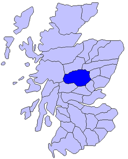
Atholl or Athole is a large historical division in the Scottish Highlands, bordering Marr, Badenoch, Lochaber, Breadalbane, Strathearn, Perth, and Gowrie. Today it forms the northern part of Perth and Kinross, Scotland.

Pitlochry is a town in the county of Perthshire in Scotland, lying on the River Tummel. It is administered as part of the council area of Perth and Kinross, and has a population of 2,776, according to the 2011 census.

Turweston is a village and civil parish in north-west Buckinghamshire, England. The village is beside the River Great Ouse, which bounds the parish to the north, west and south. Turweston is the most northwesterly parish in Buckinghamshire: the Ouse here forms the county boundary with Northamptonshire to the north and west and Oxfordshire to the south. Across the river, the Northamptonshire market town of Brackley is just west of Turweston, with the town centre about 1 mile (1.6 km) west of the village. The parish has an area of 1,295 acres (524 ha) and had a population of 211 at the 2011 Census.

Hampton in Arden is a village and civil parish located in the Forest of Arden in the Metropolitan Borough of Solihull, in the West Midlands of England. Hampton in Arden was part of Warwickshire until the 1974 boundary changes. It lies within the Meriden Gap area of countryside between Solihull and Coventry. Hampton in Arden is a typical Arden village, but is now very much a commuter settlement for nearby Birmingham, Solihull and Coventry. In 1968 the central part of the village was designated a Conservation Area, which is an "area of special architectural or historic interest, the character or appearance of which it is desirable to preserve or enhance". Its population in the 2001 census was 1,787, increasing to 1,834 at the 2011 Census.

St Giles' Cathedral, or the High Kirk of Edinburgh, is a parish church of the Church of Scotland in the Old Town of Edinburgh. The current building was begun in the 14th century and extended until the early 16th century; significant alterations were undertaken in the 19th and 20th centuries, including the addition of the Thistle Chapel. St Giles' is closely associated with many events and figures in Scottish history, including John Knox, who served as the church's minister after the Scottish Reformation.

Blair Atholl is a village in Perthshire, Scotland, built about the confluence of the Rivers Tilt and Garry in one of the few areas of flat land in the midst of the Grampian Mountains. The Gaelic place-name Blair, from blàr, 'field, plain', refers to this location. Atholl, which means 'new Ireland', from the archaic Ath Fhodla is the name of the surrounding district.

Blair Castle stands in its grounds near the village of Blair Atholl in Perthshire in Scotland. It is the ancestral home of the Clan Murray, and was historically the seat of their chief, the Duke of Atholl, though the current (12th) Duke, Bruce Murray, lives in South Africa. The castle stands in Glen Garry, and commands a strategic position on the main route through the central Scottish Highlands.

Dalry is a small town in the Garnock Valley in Ayrshire, Scotland. Drakemyre is a northern suburb.

Dunkeld is a town in Perth and Kinross, Scotland, a historic cathedral "city" on the north bank of the River Tay, opposite Birnam. It lies close to the geological Highland Boundary Fault, and is frequently described as the "Gateway to the Highlands" due to its position on the main road and rail lines north. Dunkeld has a railway station, Dunkeld & Birnam, on the Highland Main Line, and is about 25 kilometres north of Perth on what is now the A9 road. The main road formerly ran through the town, however following modernisation of this road it now passes to the west of Dunkeld.

Clan Murray is a Highland Scottish clan. The chief of the Clan Murray holds the title of Duke of Atholl. Their ancestors who established the family in Scotland in the 12th century were the Morays of Bothwell. In the 16th century descendants of the Morays of Bothwell, the Murrays of Tullibardine, secured the chiefship of the clan and were created Earls of Tullibardine in 1606. The first Earl of Tullibardine married the heiress to the Stewart earldom of Atholl and Atholl therefore became a Murray earldom in 1626. The Murray Earl of Atholl was created Marquess of Atholl in 1676 and in 1703 it became a dukedom. The marquess of Tullibardine title has continued as a subsidiary title, being bestowed on elder sons of the chief until they succeed him as Duke of Atholl.
Bolton Priory, whose full title is The Priory Church of St Mary and St Cuthbert, Bolton Abbey is a Grade I listed parish church of the Church of England in Bolton Abbey (village), within the Yorkshire Dales National Park in North Yorkshire, England. There has been continuous worship on the site since 1154, when a group of Augustinian canons moved from their original community in nearby village of Embsay and started construction of the present building, which is now situated within a scheduled monument under the Ancient Monuments and Archaeological Areas Act 1979. Despite the loss of most of the Priory buildings during the Dissolution of the Monasteries, the western half of the original nave was preserved so that the local parish could continue its worship there. There is today a full liturgical calendar, in addition to which the Priory hosts the Bolton Priory Concert Series, the Bolton Priory Celebrity Organ Recitals, the Bolton Priory Mystery Play, the Bolton Priory Live Nativity, and the annual St Cuthbert lecture. The Priory is a member of the Greater Churches Network, and welcomes more than 160,000 visitors a year.

Woodeaton or Wood Eaton is a village and civil parish about 4 miles (6.4 km) northeast of Oxford, England. It also has a special needs school called woodeaton manor school

Kirkmichael is a village located in Strathardle, Perth and Kinross, Scotland. It is 13 miles north-northwest of Blairgowrie and 12 miles east-northeast of Pitlochry on the A924 Bridge of Cally to Pitlochry road, and is linked to the A93 Perth to Aberdeen road by the B950. The village is centred around the bridge over the River Ardle.

St Mary's Church is an active Anglican parish church located in Monk's Lane, Acton, a village to the west of Nantwich, Cheshire, England. Since 1967 it has been designated a Grade I listed building. A church has been present on this site since before the time of the Domesday Survey. The tower is the oldest in Cheshire, although it had to be largely rebuilt after it fell in 1757. One unusual feature of the interior of the church is that the old stone seating around its sides has been retained. In the south aisle are some ancient carved stones dating back to the Norman era. The architectural historian Alec Clifton-Taylor includes the church in his list of 'best' English parish churches. In the churchyard is a tall 17th-century sundial. The church is an active Anglican parish church in the diocese of Chester, the archdeaconry of Macclesfield and the deanery of Nantwich. Its benefice is united with those of St David, Wettenhall, St Oswald, Worleston, and St Bartholomew, Church Minshull.

Stanley is a village on the north side of the River Tay in Perthshire, Scotland, around 6 miles north of Perth.

Caversfield is a village and civil parish about 1+1⁄2 miles (2.4 km) north of the centre of Bicester. In 1844 Caversfield became part of Oxfordshire, but until then it was always an exclave of Buckinghamshire. The 2011 Census recorded the parish's population as 1,788.
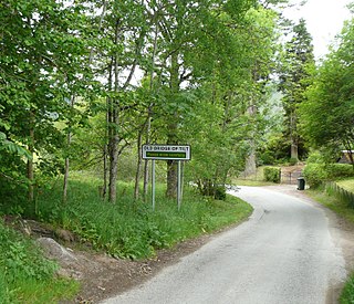
Bridge of Tilt is a village in Perthshire, Scotland, built around the River Tilt, near its confluence with the River Garry. It is 5+3⁄4 miles northwest of Pitlochry. The newer part of the village is continuous with Blair Atholl, only separated by the River Tilt. The village is located primarily on the B8079 between Pitlochry and Dunalastair Water, but the older part of the village is located further up the River Tilt. The A9 runs past the River Garry to the south of Bridge of Tilt, and connects the village with Newtonmore and Inverness in the north and Pitlochry, Perth and Stirling in the south.

St Beuno's Church, Aberffraw is a 12th-century parish church in Anglesey, north Wales. A church was established in Aberffraw in the 7th century by St Beuno, who became the abbot of Clynnog Fawr, Gwynedd. St Beuno's may have been used as a royal chapel during the early Middle Ages, as the princes of Gwynedd had a court in Aberffraw. The oldest parts of the church date from the 12th century, although it was considerably enlarged in the 16th century when a second nave was built alongside the existing structure, with the wall in between replaced by an arcade of four arches. Restoration work in 1840 uncovered a 12th-century arch in the west wall, which may have been the original chancel arch or a doorway to a western tower that has been lost. The church also has a 13th-century font, some memorials from the 18th century, and two 18th-century copper collecting shovels.

Richard and Robert Dickson were brothers, acting as architects in Scotland in the early and mid-19th century. Whilst most of their work is typified by remote country houses they are best known for their magnificent spire on the Tron Kirk in the heart of Edinburgh on the Royal Mile.
Ardblair Castle is an L-plan castle, dating from the 16th century, around 0.75 miles (1.21 km) west of Blairgowrie in Perth and Kinross, Scotland.

