
Perthshire, officially the County of Perth, is a historic county and registration county in central Scotland. Geographically it extends from Strathmore in the east, to the Pass of Drumochter in the north, Rannoch Moor and Ben Lui in the west, and Aberfoyle in the south; it borders the counties of Inverness-shire and Aberdeenshire to the north, Angus to the east, Fife, Kinross-shire, Clackmannanshire, Stirlingshire and Dunbartonshire to the south and Argyllshire to the west.

Perth is a centrally located Scottish city, on the banks of the River Tay. It is the administrative centre of Perth and Kinross council area and is the historic county town of Perthshire. It had a population of about 47,430 in 2018.

Perth and Kinross is one of the 32 council areas of Scotland, and a lieutenancy area. It is bordered by Highland and Aberdeenshire to the north, Angus, Dundee, and Fife to the east, Clackmannanshire to the south, and Stirling and Argyll and Bute to the west.
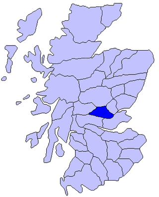
Strathearn or Strath Earn, also the Earn Valley, is the strath of the River Earn, which flows from Loch Earn to meet the River Tay in the east of Scotland.

Alyth is a town in Perth and Kinross, Scotland, five miles northeast of Blairgowrie and about 17 miles northwest of Dundee. In 2016 the town had an estimated population of 2,400.

Aberfeldy is a burgh in Perth and Kinross, Scotland, on the River Tay. A small market town, Aberfeldy is located in Highland Perthshire. It was mentioned by Robert Burns in the poem The Birks Of Aberfeldy and in the Ed Sheeran song The Hills of Aberfeldy.

Errol is a village in Perth and Kinross, Scotland, about halfway between Dundee and Perth. It is one of the principal settlements of the Carse of Gowrie. It lies just north of the River Tay. The 2016 population of Errol was estimated to be 1,500 persons, compared to 1,070 in the 2001 Census and 1,311 in the 2011 Census.

Ochil and South Perthshire was a county constituency of the House of Commons of the Parliament of the United Kingdom. It elected one Member of Parliament (MP) by the first-past-the-post system of election.

Perth and North Perthshire was a county constituency of the House of Commons of the Parliament of the United Kingdom. It elected one Member of Parliament (MP) by the first past the post system of election. The constituency was created in 2005.

Clan Hay is a Scottish clan of the Grampian region of Scotland that has played an important part in the history and politics of the country. Members of the clan are to be found in most parts of Scotland and in many other parts of the world. However, the North East of Scotland, i.e. Aberdeenshire (historic), Banffshire, Morayshire and Nairnshire Nairn (boundaries), is the heart of Hay country with other significant concentrations of Hays being found in Perthshire, especially around Perth, in the Scottish Borders, and in Shetland. Clan Hay, since coming to America, has been instrumental in the shaping and founding of America, has made significant contributions throughout the nation's history. Members of this distinguished lineage have held numerous prominent roles, including Presidents, Governors, Legislators, and military leaders. Many locations across the United States bear the family's name in recognition of their impact.
Luncarty is a village in Perth and Kinross, Scotland, approximately 4 miles north of Perth. It lies between the A9 to the west, and the River Tay to the east.
EastPerthshire was a county constituency of the House of Commons of the Parliament of the United Kingdom from 1885 to 1918. It elected one Member of Parliament (MP) by the first past the post voting system.
Perthshire North is a constituency of the Scottish Parliament (Holyrood) covering part of the council area of Perth and Kinross. It elects one Member of the Scottish Parliament (MSP) by the plurality method of election. It is one of nine constituencies in the Mid Scotland and Fife electoral region, which elects seven additional members, in addition to the nine constituency MSPs, to produce a form of proportional representation for the region as a whole.

Perthshire South and Kinross-shire is a constituency of the Scottish Parliament (Holyrood) covering part of the council area of Perth and Kinross. It elects one Member of the Scottish Parliament (MSP) by the plurality method of election. It is one of nine constituencies in the Mid Scotland and Fife electoral region, which elects seven additional members, in addition to the nine constituency MSPs, to produce a form of proportional representation for the region as a whole.

Battleby is a country house in Perth and Kinross, Scotland. It is in the parish of Redgorton, 1 kilometre (0.62 mi) west of Luncarty and 6 kilometres (3.7 mi) north of Perth. The 19th-century house is occupied by Scottish Natural Heritage, and is protected as a category B listed building. The grounds are listed on the Inventory of Gardens and Designed Landscapes in Scotland, the national listing of significant gardens, for their important plant collection.

North Inch is a large public park in Perth, Scotland. About 57 hectares in size, it is one of two "Inches" in Perth, the other being the smaller, 31-hectare South Inch, located half a mile across the city. The inches were granted to the city, when it was a royal burgh, by King Robert II in 1374. Both inches were once islands in the River Tay; today, they are connected by Tay Street, part of the A989.
Cramock Burn is an historic 2.7 mi (4.3 km)-long watercourse in Scone, Perth and Kinross, Scotland. It is a tributary of the River Tay, which it joins just north of where the River Almond flows into the Tay, on the Perth side of the river. On an 1804 estate map, it is described as a "small sluggish stream".
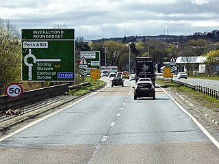
The Cross Tay Link Road is a road-construction project in Perth and Kinross, Scotland. It will link the A93 and A94 roads, near Scone, to the A9 north of the Inveralmond Roundabout, at Perth, via a new stretch of road, 3.7 miles (6.0 km) long. It will involve a three-span bridge over Scotland's longest river, the Tay, hence the project's name. A cycle path will run parallel to the bridge's carriageway.

Public transport in Perth and Kinross is available for two main modes of transport—bus and rail—assisting residents of and visitors to the Perth and Kinross council area to travel around much of its 2,041 square miles (5,290 km2).

