Dayton is the sixth-largest city in the U.S. state of Ohio and the county seat of Montgomery County. A small part of the city extends into Greene County. The 2020 U.S. census estimate put the city population at 137,644, while Greater Dayton was estimated to be at 814,049 residents. The Combined Statistical Area (CSA) was 1,086,512. This makes Dayton the fourth-largest metropolitan area in Ohio and 73rd in the United States. Dayton is within Ohio's Miami Valley region, 50 miles (80 km) north of the Greater Cincinnati area.

Montgomery County is located in the southwestern portion of the U.S. state of Ohio. As of the 2020 census, the population was 537,309, making it the fifth-most populous county in Ohio. The county seat is Dayton. The county was named in honor of Richard Montgomery, an American Revolutionary War general killed in 1775 while attempting to capture Quebec City, Canada. Montgomery County is part of the Dayton, Ohio Metropolitan Statistical Area.

Interstate 75 (I-75) is a major north–south Interstate Highway in the Great Lakes and Southeastern regions of the United States. As with most Interstates that end in 5, it is a major cross-country, north–south route, traveling from State Road 826 and SR 924 on the Hialeah–Miami Lakes border to Sault Ste. Marie, Michigan, at the Canadian border. It is the second-longest north–south Interstate Highway and the seventh-longest Interstate Highway overall.

Tipp City is a city in Miami County, Ohio, United States just outside Dayton. The population was 9,689 at the 2010 census. Formerly known as Tippecanoe, and then Tippecanoe City. Later, it was renamed to Tipp City in 1938 because another town in Ohio was likewise named Tippecanoe. The city lies in the Miami Valley and sits along Interstate 75 near the Interstate 70 interchange.
Miamisburg is a city in southern Montgomery County, Ohio, United States. The population was 19,923 at the 2020 census. A suburb of Dayton, it is part of the Dayton metropolitan area. Miamisburg is known for its industrial history, particulalry its nuclear operations during World War II, and retail factors such as the Dayton Mall and commercial business area, which is partially located in Miami Township, and as the home to the Miamisburg Mound.

The Little Miami Scenic Trail is the fourth longest paved trail in the United States, running 78.1 miles (125.7 km) through five southwestern counties in the state of Ohio. The multi-use rail trail sees heavy recreational use by hikers and bicyclists, as well as the occasional horseback rider. Over 700,000 people made use of the trail in 2014.
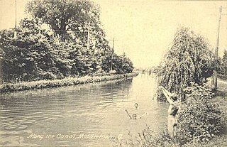
The Miami and Erie Canal was a 274-mile (441 km) canal that ran from Cincinnati to Toledo, Ohio, creating a water route between the Ohio River and Lake Erie. Construction on the canal began in 1825 and was completed in 1845 at a cost to the state government of $8,062,680.07. At its peak, it included 19 aqueducts, three guard locks, 103 canal locks, multiple feeder canals, and a few man-made water reservoirs. The canal climbed 395 feet (120 m) above Lake Erie and 513 feet (156 m) above the Ohio River to reach a topographical peak called the Loramie Summit, which extended 19 miles (31 km) between New Bremen, Ohio to lock 1-S in Lockington, north of Piqua, Ohio. Boats up to 80 feet long were towed along the canal by mules, horses, or oxen walking on a prepared towpath along the bank, at a rate of four to five miles per hour.

The Miami Valley is the land area surrounding the Great Miami River in southwest Ohio, USA, and includes the Little Miami, Mad, and Stillwater rivers as well. Geographically, it includes Dayton, Springfield, Middletown, Hamilton, and other communities. The name is derived from the Miami Indians.
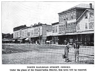
Osborn was a town located near the Haddix Road-Ohio 235 intersection at the northern edge of Wright-Patterson Air Force Base in what is now the flood-prone basin of the Huffman Dam in the U.S. state of Ohio.

The Cincinnati, Lebanon and Northern Railway (CL&N) was a local passenger and freight-carrying railroad in the southwestern part of the U.S. state of Ohio, connecting Cincinnati to Dayton via Lebanon. It was built in the late 19th century to give the town of Lebanon and Warren County better transportation facilities. The railroad was locally known as the "Highland Route", since it followed the ridge between the Little and Great Miami rivers, and was the only line not affected by floods such as the Great Dayton Flood of 1913.

State Route 55 (SR 55) is an east–west state route in western Ohio. Its western terminus is near the town of Laura at SR 571, and its eastern terminus is south of downtown Urbana at U.S. Route 68 (US 68).
WHJM, "Radio Maria" is a non-commercial FM station operating at 88.7 MHz licensed to Anna, Ohio. It is a repeater station of KJMJ (AM) 580 in Alexandria, Louisiana and is owned by Radio Maria Inc. airing inspirational music and Catholic programming for the Upper Miami Valley region of Shelby, Auglaize, Allen, Logan, Mercer, Miami and surrounding counties in West Central Ohio. It is part of the international broadcast ministry of The World Family of Radio Maria, which is based in Italy and broadcasts in over thirty countries in thirteen languages worldwide. The station also audiostreams from its website for listeners outside its immediate signal area in addition to its very own smartphone app, the Tune In app and the Alexa device.

Otterbein is a small neighborhood of historic rowhouses in Baltimore, Maryland, United States. Otterbein is immediately southwest of, and in close walking distance to, the Inner Harbor. The neighborhood is very compact, entirely located between Hanover Street and Sharp Street, and between Barre Street and Henrietta Street. It is in small parts of zip codes 21201 and 21230. It is named for Old Otterbein Church, located immediately north of the neighborhood.
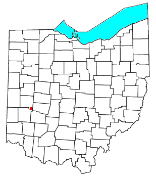
Brandt is an unincorporated community in southern Bethel Township, Miami County, Ohio, United States. Brandt is part of the Dayton Metropolitan Statistical Area. The Bethel Township Administration Facility is located in Brandt.
Interstate 75 (I-75) runs from Cincinnati to Toledo by way of Dayton in the US state of Ohio. The highway enters the state running concurrently with I-71 from Kentucky on the Brent Spence Bridge over the Ohio River and into the Bluegrass region. I-75 continues along the Mill Creek Expressway northward to the Butler County line just north of I-275. From there, the freeway runs into the Miami Valley and then passes through the Great Black Swamp before crossing into Michigan.

Interstate 70 (I-70) in the US state of Ohio provides access between Indiana and West Virginia. I-70 is a major highway for traffic within, to, from, and through Ohio. The highway is a core roadway of the Columbus metropolitan area and is of additional importance in the Dayton metropolitan area.

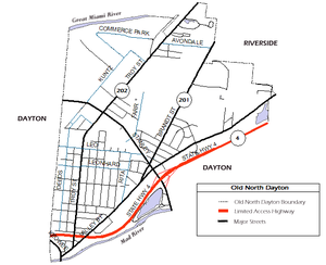
State Route 202 (SR 202) is a 20-mile (32 km) north–south state highway in the western part of the U.S. state of Ohio. The highway runs from its southern terminus at an intersection with SR 201 in Dayton to its northern terminus at a T-intersection with SR 55 in the eastern end of Troy.

The Dayton, OH Metropolitan Statistical Area, also known as Greater Dayton and the Miami Valley, as defined by the United States Census Bureau, is an area consisting of three counties in the Miami Valley region of Ohio and is anchored by the city of Dayton. As of 2020, it is the fourth largest metropolitan area in Ohio and the 73rd largest metropolitan area by population in the United States with a population of 814,049.

State Route 201 (SR 201) is a 21.69-mile (34.91 km) long north–south state highway in the western portion of the U.S. state of Ohio. The southern terminus of SR 201 is at an interchange with the SR 4 freeway in Dayton. Its northern terminus is at a T-intersection with SR 55 approximately 3.25 miles (5.23 km) east of Casstown.

The Cincinnati metropolitan area is a metropolitan area centered on Cincinnati and including surrounding counties in the U.S. states of Ohio, Kentucky, and Indiana. The area is commonly known as Greater Cincinnati.