Related Research Articles

North Toronto is a former town and informal district located in the northern part of the Old Toronto district in Toronto, Ontario, Canada. Currently occupying a geographically central location within the city of Toronto, the Town of North Toronto was incorporated in 1890, when much of the area was still farmland, and annexed by the old city of Toronto in 1912. The name is still used to refer to the area in general, although Yonge–Eglinton and Midtown Toronto are officially used.

Evanston is a neighborhood in the city of Cincinnati, Hamilton County, Ohio, United States. The population was 9,158 at the 2010 census.

West Philadelphia, nicknamed West Philly, is a section of Philadelphia, Pennsylvania. Though there is no official definition of its boundaries, it is generally considered to reach from the western shore of the Schuylkill River, to City Avenue to the northwest, Cobbs Creek to the southwest, and the SEPTA Media/Elwyn Line to the south. An alternate definition includes all city land west of the Schuylkill; this would also include Southwest Philadelphia and its neighborhoods. The eastern side of West Philadelphia is also known as University City.

The Boston-area trolleybussystem forms part of the public transportation network serving Greater Boston in the U.S. state of Massachusetts. It opened on April 11, 1936, and since 1964 has been operated by the Massachusetts Bay Transportation Authority (MBTA). It currently includes two physically isolated networks: one serving the towns of Cambridge, Belmont, and Watertown, the other – the Silver Line (Waterfront) – located in the city of Boston proper. Prior to 1964, several additional trolleybus lines were in operation in Boston proper. Measured by fleet size, the system was the third-largest trolleybus system in the United States at its peak, with only the Chicago and Atlanta systems having more trolleybuses than Boston's 463.
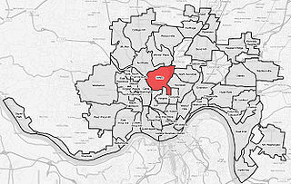
Clifton is a neighborhood in the north central part of Cincinnati, Ohio, United States. The population was 8,304 at the 2010 census.

The University of Dayton Ghetto, located in Dayton, Ohio, is home to upperclassmen at the University of Dayton (UD). Housing in "the Ghetto" is leased in an arrangement that resembles both traditional university housing and a landlord/tenant relationship. Tracing its history back to the 1870s, the neighborhood now includes more than 200 university-owned houses as well as landlord-owned houses, high-density housing and gathering spaces. With the inclusion of Holy Angels and The Darkside, or officially "the North Student Neighborhood", two smaller neighborhoods the university owns property in, there are more than 400 houses currently used as student residential space. Because of the area's age, the university has been engaged in a program to renovate and update the houses, and several additional changes to the neighborhood are expected in the coming years as part of the university's Master Plan.

Hilltop is one of the largest neighborhoods in Columbus, Ohio, which is located west of the Franklinton area. The Greater Hilltop area contains newer and historic neighborhoods, schools, various stores, industrial areas, and recreational facilities. The development pattern is considered a distinct suburb. The majority of the area is predominantly single family residential.
Columbus, the state capital and Ohio's largest city, has numerous neighborhoods within its city limits. Neighborhood names and boundaries are not officially defined. They may vary or change from time to time due to demographic and economic variables.
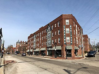
East Walnut Hills is a neighborhood on the Southeast side of Cincinnati, Ohio. The population was 3,794 at the 2010 census.

Joseph is a bronze bell that hangs 125 feet (38 m) into the bell tower of Neo-Gothic Saint Francis De Sales Catholic Church in Cincinnati, Ohio, United States. The endearing moniker Big Joe is a combination of the names of Joseph T. Buddeke, the largest donor of the project, and Big Ben, the great bell in the iconic Palace of Westminster clock tower in London.

The Alexandra is a historic apartment building located on Gilbert Avenue in the Walnut Hills neighborhood of Cincinnati, Ohio, United States. Constructed in 1904 as the neighborhood's first large apartment building, it was one of many such buildings constructed for the real estate management firm of Thomas J. Emery's Sons. It has been named a historic site.
Twin Towers is a neighborhood of Dayton, Ohio, United States. It is bounded by Wayne Avenue, Wyoming Street, Steve Whalen Boulevard and the U.S. Route 35 expressway.

Saint Paul, Minnesota is noted for its neighborhoods. The city has been called "fifteen small towns with one mayor", owing to the neighborhood-based life of much of the city. Saint Paul is partially governed by not 15 but 17 City Districts.

Forest Park Southeast (FPSE) is a neighborhood of St. Louis, Missouri. It is bordered by Interstate 64 to the north, Vandeventer Avenue to the east, Interstate 44 to the south, and Kingshighway Boulevard and Forest Park to the west. Adjoining neighborhoods include Kings Oak and The Hill to the west, Southwest Garden to the south, Botanical Heights to the southeast, Midtown to the east, and the Central West End to the north.

Corryville is a neighborhood in Cincinnati, Ohio, east of the University of Cincinnati, southeast of Clifton, south and west of Avondale, northwest of Walnut Hills, and north of Mount Auburn. The population was 3,327 at the 2010 census.

Walnut Hills is a neighborhood in Cincinnati, Ohio, United States. One of the city’s oldest hilltop neighborhoods, it is a large diverse area on the near east side of Cincinnati. Eden Park is the gateway to Walnut Hills when driving north from downtown, and the University of Cincinnati is less than 10 minutes away. The neighborhood is redeveloping, restoring many of its buildings and introducing new businesses to the area. The population was 6,495 at the 2010 census.

Duboce and Church is a light rail stop on the Muni Metro J Church and N Judah lines, located in the Duboce Triangle neighborhood of San Francisco, California. Just east of the station, the two lines enter the Market Street subway. The station originally opened with the 22 Fillmore line in 1895.
In Atlanta, Georgia, trolleybuses, generally called trackless trolleys there, were a major component of the public transportation system in the middle decades of the 20th century, carrying some 80 percent of all transit riders during the period when the system was at its maximum size. At the end of 1949 Atlanta had a fleet of 453 trolleybuses, the largest in the United States, and it retained this distinction until 1952, when it was surpassed by Chicago.

The Dayton trolleybus system forms part of the public transportation network serving Dayton, in the state of Ohio, United States. Opened on April 23, 1933, it presently comprises seven lines, and is operated by the Greater Dayton Regional Transit Authority, with a fleet of 54 trolleybuses.

Woodland Park is a residential neighborhood located in the Near East Side of Columbus, Ohio that houses approximately 1,500 residents. The neighborhood was previously home to such figures as artist Emerson Burkhart, cartoonist Billy Ireland, and judge William Brooks. Established in the early 20th century, Woodland Park has grown from its planned neighborhood roots into a modest neighborhood that contains various faith communities, schools, sources of entertainment and recreation, and borders an extension of the Ohio State University medical center.