Old Northside Historic District

Last updated
Old Northside Historic District
Old northside architectre.jpg
Old Northside Architecture
Location map Indianapolis.png
Red pog.svg
USA Indiana location map.svg
Red pog.svg
Usa edcp location map.svg
Red pog.svg
LocationRoughly bounded by Interstate 65 and 16th, Bellefontaine, and Pennsylvania Streets, Indianapolis, Indiana
Coordinates 39°47′1.87″N86°9′14.98″W / 39.7838528°N 86.1541611°W / 39.7838528; -86.1541611 Coordinates: 39°47′1.87″N86°9′14.98″W / 39.7838528°N 86.1541611°W / 39.7838528; -86.1541611
Area170 acres (69 ha)
Architectural styleLate Victorian
NRHP reference No. 78000049 [1]
Added to NRHPMarch 24, 1978

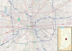
Old Northside is a residential neighborhood near downtown in Indianapolis, Indiana. It is bordered by 16th Street on the north, Pennsylvania Street on the west, Interstate I-65 on the south, and Bellefontaine Street on the east. The Monon Trail runs along the eastern edge of The Frank and Judy O'Bannon Old Northside Soccer Park. [2]

Contents

Old Northside was added to the National Register of Historic Places in 1978 and is home to many residences from the Victorian era. [1]

History

Old Northside was a prominent residential neighborhood in the late 19th century, when many of Indianapolis' wealthier residents built mansions in the area. Old Northside was home to Benjamin Harrison (23rd President of the United States), Ovid Butler (founder of Butler University) and other notable figures, including magnates of the L.S. Ayres department store. Indiana author Meredith Nicholson was also a resident for many years and wrote his most noted work House of a Thousand Candles while in residence. [3]

Old Northside was also the original location of Indianapolis' Butler University, then named North Western Christian University, which was later relocated to the town of Irvington. [3] [4]

The neighborhood began a slow decline in the early 1910s as architectural tastes changed and families built homes further north in Indianapolis. Over several decades, homes were demolished and others fell into disrepair.

In 1937, the Homeowner Loan Corporation (HOLC) classified 73 Indianapolis neighborhoods into four categories based on perceived investment risk. The Old Northside was graded "C", or hazardous, and colored yellow, and was surrounded by redlined neighborhoods. [5] In the late 1960s, residents began restoring remaining buildings of architectural significance, and petitioned the city for historic recognition. By the 1990s, the Old Northside was gentrified, with the population of white residents more than doubling between 1970 and 2016. [6] [7]

Old Northside received historic designation in late 1978 after adopting a plan for preserving the architecture and history of the neighborhood. Disagreement arose between those seeking National Register designation and lower-income residents of the Old Northside, who were represented by the Citizens Neighborhood Coalition and feared displacement from their homes. A 1979 IUPUI study determined that minimal displacement had taken place due to the historic preservation of the neighborhood. [8]

Preservation of the neighborhood's history is overseen by the Indianapolis Historic Preservation Commission. [9]

Residences and museums

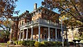
The President Benjamin Harrison Home and the Morris-Butler House, both on the National Register of Historic Places, are located in Old Northside and are open to the public for tours and special events. In 2010–2011, the former Central Avenue Methodist Church, later known as the Old Centrum, underwent a multimillion-dollar major restoration as a performance venue and statewide headquarters of Indiana Landmarks and is now known as the Indiana Landmarks Center. The former home of Thomas Taggart is now the national headquarters of Delta Sigma Phi fraternity. [10]

Parks

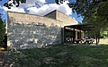
There are three parks related to Old Northside, all created with funding from the Old Northside Foundation. Great Oak Commons is a park created by the neighborhood from several empty lots and is landscaped as a Victorian walking park with a central fountain, gas lighting, a gazebo and a sensory garden filled with fragrant perennial flowers. Shawn Grove Park is a children's park with play equipment. The Frank and Judy O'Bannon Soccer Park was created by the city of Indianapolis on the east edge of the neighborhood, with the help of Old Northside Foundation. It is now maintained by Indy Parks. It was reclaimed from abandoned space near the former Monon train tracks and is used by several children's summer soccer leagues.

Neighborhood organizations

The Old Northside Neighborhood Association was created in 1979, and has been active in preserving the historic architecture of the neighborhood and providing cultural and social activities for the neighborhood. [11]

The Old Northside Neighborhood Foundation was created in 1990 to raise funds for neighborhood projects, including funding for the neighborhood parks and conversion of street lights to historically appropriate designs. [11]

Related Research Articles

<span class="mw-page-title-main">Haughville, Indianapolis</span> United States historic place

Haughville is a neighborhood west of downtown Indianapolis. Its borders are roughly White River Parkway to the east, Tibbs Avenue to the west, 16th Street to the north, and Michigan Street to the south. It was first settled in the 1830s and grew after a bridge over White River was built connecting to Indianapolis, which annexed the town in 1897. The modern version of the bridge is also the connection between Haughville on the west side of the river and the Sidney & Lois Eskenazi Hospital and Indiana University - Purdue University Indianapolis on the east. The population in the late 1890s included Slovenian, German, and Irish immigrants, among other European immigrants. In the 21st century, the neighborhood suffers from a high crime rate and low property values.

<span class="mw-page-title-main">Benjamin Harrison Presidential Site</span> Presidential museum in Indianapolis, Indiana, U.S.

The Benjamin Harrison Presidential Site, previously known as the Benjamin Harrison Home, is the former home of the twenty-third president of the United States, Benjamin Harrison. It is in the Old Northside Historic District of Indianapolis, Indiana. Harrison's 16-room house was built from 1874 to 1875. It was from the front porch of the house that Harrison instituted his famous Front Porch Campaign in the 1888 United States presidential campaign, often speaking to crowds on the street. In 1896, Harrison renovated the house and added electricity. He died there in a second-story bedroom in 1901. Today it is owned by the Arthur Jordan Foundation and operated as a museum to the former president by the Benjamin Harrison Foundation.

<span class="mw-page-title-main">Irvington Historic District (Indianapolis)</span> Historic district in Indiana, United States

The neighborhood of Irvington, named after Washington Irving, includes Irvington Historic District, a historic district in Indianapolis, Indiana. The historic district is a 545-acre (221 ha) area that was listed on the National Register of Historic Places in 1987. That year, the district included 2,373 contributing buildings, 5 other contributing structures, and 2 contributing sites.

<span class="mw-page-title-main">Morris–Butler House</span> Historic house in Indiana, United States

The Morris–Butler House is a Second Empire-style house built about 1864 in the Old Northside Historic District of Indianapolis, Indiana. Restored as a museum home by Indiana Landmarks between 1964 and 1969, the American Civil War-era residence was the non-profit organization's first preservation project. Restoration work retained some of its original architectural features, and the home was furnished in Victorian and Post-Victorian styles. Its use was changed to a venue for Indiana Landmarks programs, special events, and private rentals following a refurbishment in 2013. Regular daily tours of the property have been discontinued.

<span class="mw-page-title-main">Corydon Historic District</span> Historic district in Indiana, United States

The Corydon Historic District is a national historic district located in Corydon, Indiana, United States. The town of Corydon is also known as Indiana's First State Capital and as Historic Corydon. The district was added to the National Register of Historic Places in 1973, but the listing was amended in 1988 to expand the district's geographical boundaries and include additional sites. The district includes numerous historical structures, most notably the Old Capitol, the Old Treasury Building, Governor Hendricks' Headquarters, the Constitution Elm Memorial, the Posey House, the Kintner-McGrain House, and The Kintner House Inn, as well as other residential and commercial sites.

Meridian-Kessler is a residential neighborhood located about 4 miles (6.4 km) north of downtown Indianapolis. It is bounded on the north by Kessler Boulevard, on the east by the Monon Trail greenway corridor, on the south by 38th Street, and to the west by Meridian Street. Meridian Street forms a shared boundary with the adjacent Butler-Tarkington neighborhood.

<span class="mw-page-title-main">Golden Hill Historic District (Indianapolis, Indiana)</span> Historic district in Indiana, United States

Golden Hill is an affluent and historic neighborhood overlooking the White River on the west side of Indianapolis's Center Township, in Marion County, Indiana. The district is bounded on the east by Clifton Street, which is west of Martin Luther King Jr. Boulevard ; on the west by the White River and the Central Canal; on the south by Thirty-sixth Street; and on the north by Woodstock Country Club, immediately south of Thirty-eighth Street. Golden Hill is noted for its collection of homes designed by several of the city's prominent architects. The estate homes reflect several styles of period revival architecture. The district is known as for its community planning and remains an exclusive enclave for the city's prominent families. Golden Hill was added to the National Register of Historic Places in 1991.

<span class="mw-page-title-main">Indiana Landmarks</span> Non-profit historic preservation organization in U.S. state of Indiana

Indiana Landmarks is America's largest private statewide historic preservation organization. Founded in 1960 as Historic Landmarks Foundation of Indiana by a volunteer group of civic and business leaders led by Indianapolis pharmaceutical executive Eli Lilly, the organization is a private non-governmental organization with nearly 6,000 members and an endowment of over $40-million. The organization simplified its name to Indiana Landmarks in 2010.

<span class="mw-page-title-main">Lockerbie Square Historic District</span> Historic district in Indiana, United States

Lockerbie Square Historic District is a national historic district on the National Register of Historic Places within Indianapolis, Indiana, listed on February 23, 1973, with a boundary increase on July 28, 1987. It is noted for its Federal, Italianate, and Queen Anne style architecture. The original platting of Lockerbie Square, done by Jannett Smith Lockerbie McOuat and named for her father, Scottish immigrant George Murray Lockerbie, was between 1847 and 1850. The 1960s saw an immense effort to save the buildings within the district, becoming the first historic district in Indianapolis. Many of the buildings date from 1855 to 1930. James Whitcomb Riley, famed Hoosier poet, lived in the district for over two decades. He was known to give candy to local children on his regular walks.

<span class="mw-page-title-main">Judy O'Bannon</span>

Judith "Judy" O'Bannon Willsey is the former First Lady of the State of Indiana, serving in that role from January 13, 1997, to September 13, 2003, during the administration of her husband Governor Frank O'Bannon. She has been a leader in community development and historic preservation throughout much of her life, including having helped launch and then serving as chair of the Indiana Main Street program, and serving on the boards of the Indiana Landmarks foundation, the Indiana State Museum and the National Trust for Historic Preservation. She is also an Emmy-winning host and producer of the WFYI-TV public television series Communities Building Community and Judy O'Bannon's Foreign Exchange as well as several one-time specials, and as the chair of O'Bannon Publishing Company, published two weekly newspapers, including the award-winning The Corydon Democrat.

<span class="mw-page-title-main">Washington Park Historic District (Indianapolis, Indiana)</span> Historic district in Indiana, United States

The Washington Park Historic District is a national historic district located in Indianapolis, Indiana. It was listed on the National Register of Historic Places on June 24, 2008. It comprises nearly 60 acres (240,000 m2) and is located 4 miles (6.4 km) north of downtown Indianapolis, in the south-central part of the Meridian-Kessler neighborhood. The district includes all properties south of 43rd Street and north of 40th Street, and west of Central Avenue and east of the alley running north and south between Pennsylvania and Meridian Streets; Washington Boulevard runs north-south through the center of the district. It includes 110 contributing buildings, ranging mostly from mansions to small bungalows, and three non-contributing buildings.

<span class="mw-page-title-main">Prairie Avenue</span> Thoroughfare in Chicago, United States

Prairie Avenue is a north–south street on the South Side of Chicago, which historically extended from 16th Street in the Near South Side to the city's southern limits and beyond. The street has a rich history from its origins as a major trail for horseback riders and carriages. During the last three decades of the 19th century, a six-block section of the street served as the residence of many of Chicago's elite families and an additional four-block section was also known for grand homes. The upper six-block section includes part of the historic Prairie Avenue District, which was declared a Chicago Landmark and added to the National Register of Historic Places.

<span class="mw-page-title-main">Oliver Johnson's Woods Historic District</span> Historic district in Indiana, United States

Oliver Johnson's Woods is a historic district and neighborhood on the northern side of Indianapolis, Indiana, United States. Located in southern Washington Township, the district occupies the site of what was once the family farm of Oliver Johnson. Born on the present site of the Indiana State Fairgrounds, Johnson grew up in a pioneer family that lived on the edge of the state capital city. Upon attaining adulthood, he bought property a short distance to the west, to which he moved in 1846. Here, he built a larger farmhouse in 1862, and he tilled the soil for most of the rest of his life. As Indianapolis grew northward, it reached the Johnson farm in the early twentieth century; the aged farmer and his sons saw the city's growth as an opportunity for financial gain, and in 1905 they announced the platting of 0.25 square miles (0.65 km2) of their property into individual lots. They chose an advantageous time to sell their property; as the new residents began to build their homes, an interurban railway was built along College Avenue on the district's western side that connected downtown with Broad Ripple. Many prosperous businessmen were attracted by the development's large lots and wooded streets; the city annexed Oliver Johnson's Woods in 1912, and by the outbreak of World War II, the streets were filled with large houses built in a wide variety of architectural styles. These early residents came from many different ethnicities: European immigrants were becoming more prosperous and leaving their ethnic enclaves, and new neighborhoods such as Oliver Johnson's Woods appealed to them. Among the neighborhood's leading residents was a colony of Jews of German descent.

<span class="mw-page-title-main">Cottage Home Historic District</span> Historic district in Indiana, United States

The Cottage Home Historic District is a historic district and neighborhood located on the near east side of Indianapolis, Indiana. A small portion of Cottage Home is listed on the National Register of Historic Places while a larger area is listed on the state and local levels. Known for its preponderance of "cottage-style" homes built with strong Victorian influences, Cottage Home has historically been a working class neighborhood. Numerous industrial buildings are also scattered throughout the district, providing a base of economic activity. Today, however, many of these buildings are vacant, providing a special challenge to preservation and urban renewal efforts.

<span class="mw-page-title-main">Centennial Neighborhood District</span> Historic district in Indiana, United States

Centennial Neighborhood District is a national historic district located at Lafayette, Tippecanoe County, Indiana, United States. The area originated as the Bartholomew and Davis Additions to Lafayette in 1829. Growth came rapidly after the Wabash and Erie Canal arrived in 1843, and continued with the arrival of the railroad in 1853. The Centennial Neighborhood Historic District takes its name from the Centennial School, which was constructed in 1876 on the centennial of the nation. The school was located on the northeast corner of Brown Street at North 6th Street. It has since been removed and a park was created at its original location.

<span class="mw-page-title-main">Downtown Lafayette Historic District</span> Historic district in Indiana, United States

Downtown Lafayette Historic District is a national historic district located at Lafayette, Tippecanoe County, Indiana. Lafayette began in 1825 as a transportation center for the west central area of Indiana. Its development and growth reflects the changes in transportation over the intervening years. From its location along the Wabash River, it grew first with river travel then for a short while from the Wabash and Erie Canal. When the railroads arrived in the 1850s, the town began to grow, initially along the rail lines. The Downtown Lafayette Historic District reflects these early changes.

Tee Pee Restaurant was a drive-in restaurant in Indianapolis, Indiana, that began business in 1932. In 1939, the original building on Fall Creek Boulevard was replaced with one having a central stuccoed teepee-shaped section with identical flanking wings. A cantilevered canopy extended around the building. Additions were made to the wings in 1952.

<span class="mw-page-title-main">Ransom Place Historic District</span> Historic district in Indiana, United States

Ransom Place Historic District is a national historic district in Indianapolis, Indiana, United States. The district consists mainly of a six-square block in a historically Black residential section of Indianapolis, located just one block from Indiana Avenue. It was originally developed during the 1880s and 1890s, coinciding with the growth of Indiana Avenue as the central commercial district for Indianapolis's Black population at that time. It was listed on the National Register of Historic Places in 1992.

<span class="mw-page-title-main">South Side Turnverein Hall</span> United States historic place

South Side Turnverein Hall is a historic social club and gymnasium in the Bates-Hendricks neighborhood of Indianapolis, Indiana, affiliated with the city's German-American community. It was built in 1900 by prominent architects Vonnegut & Bohn, whose managing partners Bernard Vonnegut, Sr. and Arthur Bohn were members of the burgeoning German-American community in Indianapolis. The architects were also known for designing the Athenæum, another German-American social club in the city. The South Side Turnverein was an important gathering place for Indianapolis' south side German community until its decline in the 1940s. It was sold to investors in 1978 to be used as an athletic club.

References

  1. 1 2 "National Register Information System". National Register of Historic Places . National Park Service. July 9, 2010.
  2. "Old Northside Neighborhood Association - Home". www.oldnorthside.org. Retrieved 2017-02-20.
  3. 1 2 "Old Northside Historic Plan" (PDF).
  4. "Ovid Butler Biography". Archived from the original on 2008-05-15.
  5. Nowlin, Jeramy Townsley, Unai Miguel Andres, Matt (2021-06-24). "The Lasting Impacts of Segregation and Redlining". SAVI. Retrieved 2023-05-04.
  6. "Neighborhood Change 1970-2016". SAVI. Retrieved 2023-05-04.
  7. "Exploring Neighborhood Change, 1970-2016". www.savi.org. Retrieved 2023-05-04.
  8. "Old Northside". indyencyclopedia.org. 2021-04-25. Retrieved 2023-05-04.
  9. "Tour - Old Northside Neighborhood - PocketSights". pocketsights.com. Retrieved July 19, 2020.
  10. "Indiana State Historic Architectural and Archaeological Research Database (SHAARD)" (Searchable database). Department of Natural Resources, Division of Historic Preservation and Archaeology. Retrieved 2016-08-01.Note: This includes Cheri Lynn (July 1976). "National Register of Historic Places Inventory Nomination Form: Old Northside Historic District" (PDF). Retrieved 2016-08-01. and Accompanying photographs
  11. 1 2 "Old Northside Neighborhood - Home". www.oldnorthside.org.