The Eads Bridge is a combined road and railway bridge over the Mississippi River connecting the cities of St. Louis, Missouri, and East St. Louis, Illinois. It is located on the St. Louis riverfront between Laclede's Landing to the north, and the grounds of the Gateway Arch to the south. The bridge is named for its designer and builder, James Buchanan Eads. Work on the bridge began in 1867, and it was completed in 1874. The Eads Bridge was the first bridge across the Mississippi south of the Missouri River. Earlier bridges were located north of the Missouri, where the Mississippi is smaller. None of the earlier bridges survived, which means that the Eads Bridge is also the oldest bridge on the river.

The Stan Musial Veterans Memorial Bridge is a bridge across the Mississippi River in the United States between St. Clair County, Illinois, and the city of St. Louis, Missouri. Built between April 19, 2010, and July 2013, the bridge opened on February 9, 2014. The cable-stayed bridge has a main span of 1,500 feet (460 m).
The Avenue of the Saints is a 563-mile-long (906 km) highway in the Midwestern United States that connects St. Louis, Missouri, and St. Paul, Minnesota.

Route 364, known locally as the Page Extension, the Page Avenue Freeway, the Page Expressway, or simply the Extension, is a freeway that connects St. Louis County in Maryland Heights with St. Charles County in Lake St. Louis via the Veterans Memorial Bridge over the Missouri River. The highway is a designated auxiliary state route of I-64.

Missouri Route 370 (Route 370) is a freeway that connects St. Louis County with St. Charles County via the Discovery Bridge over the Missouri River. The St. Charles County segment of the freeway is signed as the Patrick J. Bray Memorial Highway while in St. Louis County it is signed as the Officer Scott H. Armstrong Memorial Highway.

Route 115 is a highway in the St. Louis, Missouri area. Its western terminus is at exit 237 of Interstate 70 (I-70) in Berkeley near Lambert-St. Louis International Airport. Route 115's eastern terminus is also at I-70, at exit 248A, in St. Louis, near the McKinley Bridge. The road is locally known as Natural Bridge Road, Natural Bridge Avenue, and Salisbury Street. It is one of two Missouri Highways that has an odd-numbered designation, yet runs in an east–west direction.

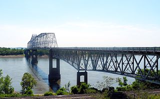
The Jefferson Barracks Bridge, officially the Jefferson Barracks Memorial Arch Bridge and locally referred to as the JB Bridge, is a pair of bridges across the Mississippi River on the south side of St. Louis, Missouri metropolitan area. Each bridge is 3,998 feet (1,219 m) long with a 909-foot (277 m) long arch bridge spanning the shipping channel. The northern bridge was built in 1983, and the southern opened in 1992. A delay occurred during the construction of the southern bridge when a crane dropped a section of it into the river and it had to be rebuilt.
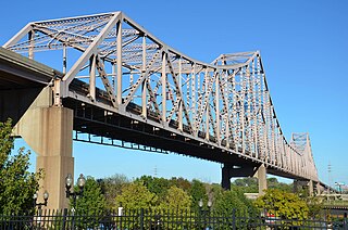
The Martin Luther King Bridge in St. Louis, Missouri, is a cantilever truss bridge of about 4,000 feet (1,200 m) in total length across the Mississippi River, connecting St. Louis with East St. Louis, Illinois. Opened in 1951, the bridge serves as traffic relief connecting the concurrent freeways of Interstate 55, Interstate 64, and U.S. Route 40 with the downtown streets of St. Louis. It was renamed for King in 1968 after the national civil rights leader was assassinated that year.

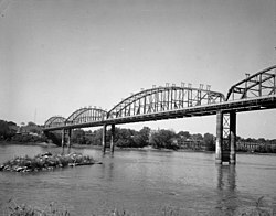
The Columbia–Wrightsville Bridge, officially the Veterans Memorial Bridge, spans the Susquehanna River between Columbia and Wrightsville, Pennsylvania, and carries Pennsylvania Route 462 and BicyclePA Route S. Built originally as the Lancaster-York Intercounty Bridge, construction began in 1929, and the bridge opened September 30, 1930. On November 11, 1980, it was officially dedicated as Veterans Memorial Bridge, though it is still referenced locally as the Columbia–Wrightsville Bridge.

Forgottonia, also spelled Forgotonia, is the name given to a 16-county region in Western Illinois in the late 1960s and early 1970s. This geographic region forms the distinctive western bulge of Illinois that is roughly equivalent to "The Tract", the Illinois portion of the Military Tract of 1812, along and west of the Fourth Principal Meridian. Since this wedge-shaped region lies between the Illinois and Mississippi rivers, it has historically been isolated from the eastern portion of Central Illinois.
The Great River Bridge is an asymmetrical, single tower cable-stayed bridge over the Mississippi River. It carries U.S. Route 34 from Burlington, Iowa to the town of Gulfport, Illinois.
The Chester Bridge is a continuous truss bridge connecting Missouri's Route 51 with Illinois Route 150 across the Mississippi River between Perryville, Missouri and Chester, Illinois. It is the only motor-traffic bridge spanning the Mississippi River between St. Louis and Cape Girardeau, Missouri.

The Discovery Bridge is a pair of truss bridges carrying Missouri Route 370 across the Missouri River between St. Louis County and St. Charles County, in the U.S. state of Missouri. The bridge was built between 1989 and 1992. Massman Construction built the river substructure and erected the steel girders. The St Charles pier is founded on rock. Piers 2-4 are supported by 6' diameter drilled shafts. Pier 5 on the St Louis County side is founded on Hp14-117 piling. The two trusses were fabricated by Stupp Brothers and erected approximately 500' downstream on falsework and floated into their final position after their transfer to barges. The land approaches substructure and concrete girders were built by Fred Weber. The entire deck was built by Kozney Wagner.
The Blanchette Memorial Bridge carries Interstate 70 across the Missouri River between St. Louis County and St. Charles County, Missouri. It is formed from a pair of twin cantilever bridges and opened in 1959, with a second bridge opened in 1979. At the bridge's crossing, the Missouri River reaches an average depth of 45 feet. It is the area's busiest bridge, handling an average of 165,000 vehicle transits per day. Construction of the first interstate highway project started west of the bridge's present location.
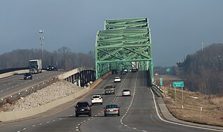
The Daniel Boone Bridge is the name for two bridges carrying Interstate 64, U.S. Route 40, U.S. Route 61 and the Avenue of the Saints across the Missouri River between St. Louis County and St. Charles County, Missouri. The older bridge, which carries westbound traffic, is a continuous truss bridge, while the newer bridge, which carries eastbound traffic, is a deck girder bridge.
The Armour-Swift-Burlington (ASB) Bridge, also known as the North Kansas City Bridge and the LRC Bridge, is a rail crossing over the Missouri River in Kansas City, Missouri, that formerly also had an upper deck for automobile traffic.

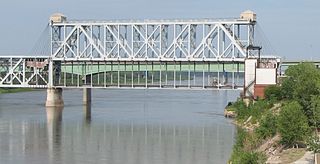
The Bellefontaine Bridge is a four-span truss railroad bridge over the Missouri River between St. Charles County, Missouri, and St. Louis County, Missouri. It has four 440-foot (130 m) spans. Construction started on July 4, 1892, and the bridge opened on December 27, 1893.

Interstate 70 (I-70) in the US state of Missouri is generally parallel to the Missouri River. This section of the transcontinental interstate begins at the Kansas state line on the Lewis and Clark Viaduct, running concurrently with U.S. Route 24 (US 24), US 40 and US 169, and the east end is on the Stan Musial Veterans Memorial Bridge in St. Louis.

The Red River Bridge was a truss bridge crossing the Red River at Garland, Arkansas. It carried vehicular traffic from 1931 to 1990 and has since been demolished.

The Gillespie Dam Bridge is a through truss bridge spanning the Gila River in Maricopa County, in the U.S. state of Arizona. The bridge was constructed to bypass a concrete apron through the river in front of the Gillespie Dam, which was often closed due to flooding. Construction of the bridge started in 1925 and completed in 1927. From its opening until 1956, the bridge was part of U.S. Route 80 (US 80), a transcontinental highway between San Diego, California and Tybee Island, Georgia. The bridge was restored in 2012 by Maricopa County for the Arizona Centennial and now includes an educational interpretive center for visitors. The bridge became part of Historic US 80 in 2018.