
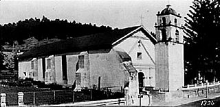
Ventura, formally known as San Buenaventura, is a city on the Central Coast of California and the county seat of Ventura County. The population was 110,763 at the 2020 census. Ventura is a popular tourist destination, owing to its historic landmarks, beaches, and resorts.
Rancho Camulos, now known as Rancho Camulos Museum, is a ranch located in the Santa Clara River Valley 2.2 miles (3.5 km) east of Piru, California and just north of the Santa Clara River, in Ventura County, California. It was the home of Ygnacio del Valle, a Californio alcalde of the Pueblo de Los Angeles in the 19th century and later elected member of the California State Assembly. The ranch was known as the Home of Ramona because it was widely believed to have been the setting of the popular 1884 novel Ramona by Helen Hunt Jackson. The novel helped to raise awareness about the Californio lifestyle and romanticized "the mission and rancho era of California history."

The Rancho San Andrés Castro Adobe is a historic house in California.
Rancho San Antonio, also known as the Peralta Grant, was a 44,800-acre (181 km2) land grant by Governor Pablo Vicente de Solá, the last Spanish governor of California, to Don Luís María Peralta, a sergeant in the Spanish Army and later, commissioner of the Pueblo of San José, in recognition of his forty years of service. The grant, issued on August 3, 1820, embraced the sites of the cities of San Leandro, Oakland, Alameda, Emeryville, Piedmont, Berkeley, and Albany.
José Francisco Ortega was an Californio soldier and early settler of Alta California. A member of the Portolá expedition in 1769, Ortega stayed on to become the patriarch of an important Californio family.

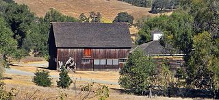
Rancho Petaluma Adobe is a historic ranch house in Sonoma County, California. It was built from adobe bricks in 1836 by order of Mariano Guadalupe Vallejo. It was the largest privately owned adobe structure built in California and is the largest example of the Monterey Colonial style of architecture in the United States. A section of the former ranch has been preserved by the Petaluma Adobe State Historic Park and it is both a California Historic Landmark and a National Historic Landmark. The Rancho Petaluma Adobe State Historic Park is located on Adobe Road on the east side of the present-day town of Petaluma, California.
Olompali State Historic Park is a 700-acre (2.8 km2) California State Park in Marin County, California. It is constituted of the former Rancho Olómpali and was the site of the famed Battle of Olómpali during the Bear Flag Revolt. Rancho Olómpali was purchased by the Californian government in 1977, which turned it into a public park.

Rancho San Francisco was a land grant in present-day northwestern Los Angeles County and eastern Ventura County, California. It was a grant of 48,612 acres (19,673 ha) by Governor Juan B. Alvarado to Antonio del Valle, a Mexican army officer, in recognition for his service to Alta California. It is not related to the city of San Francisco.

The Dana Adobe & Cultural Center or "Casa de Dana" is a historic landmark in Nipomo, California. It was the home of Boston sea captain William Dana, who in 1837 was granted the 37,888-acre (153.33 km2) Rancho Nipomo in Southern California. Captain Dana hosted figures such as Henry Tefft and John C. Fremont in his Nipomo home, which also served as an important exchange point on California's first official mail route between Monterey and Los Angeles.

Rancho Los Encinos was a Spanish grazing concession, and later Mexican land granted cattle and sheep rancho and travelers way-station on the El Camino Real in the San Fernando Valley, in present-day Encino, Los Angeles County, California. The original 19th-century adobe and limestone structures and natural warm springs are now within the Los Encinos State Historic Park.

Rancho Guajome Adobe is a historic 19th-century hacienda in Rancho Guajome Adobe County Park, on North Santa Fe Avenue in Vista, San Diego County, California. Built in 1852–53, it is a well-preserved but late example of Spanish-Mexican colonial architecture, and was designated a National Historic Landmark in 1970. It is also a California Historical Landmark and on the National Register of Historic Places.
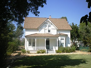
The historic Simi Adobe–Strathearn House served as the headquarters of Rancho Simi, also known as Rancho San José de Nuestra Senora de Altagracia y Simi, one of the land grants in Alta California by the Spanish government. The name derives from Shimiji, the name of the Chumash village here before the Spanish. Rancho Simi was the earliest Spanish colonial land grant within Ventura and Santa Barbara Counties. At 113,000 acres, Rancho Simi was one of the state's largest land grants.

La Casa Alvarado, also known as the Alvarado Adobe, is a historic adobe structure built in 1840 and located on Old Settlers Lane in Pomona, California. It was declared a historic landmark in 1954 and added to the National Register of Historic Places in 1978.

La Casa Primera de Rancho San Jose is a historic adobe structure built in 1837 in Pomona, California. It is the oldest home located in the Pomona Valley and in the old Rancho San Jose land grant. It was declared a historic landmark in 1954 and added to the National Register of Historic Places in April 1975.

Rancho Las Vírgenes was a 17,760-acre (71.9 km2) land grant in the Santa Monica Mountains and Simi Hills, in present day western Los Angeles County, California. The lands of the Rancho Las Vírgenes included present day Agoura Hills, Oak Park, and Westlake Village and part of the Santa Monica Mountains.
Rancho San Miguel was a 4,694-acre (19.00 km2) Mexican land grant in present-day Ventura County, California given in 1841 by Governor Juan Bautista Alvarado to Felipe Lorenzana and Raymundo Olivas. The grant encompassed the area of present-day City of Ventura not within Rancho Ex-Mission San Buenaventura, with the Santa Clara River marking its southern boundary.
Rancho Santa Clara del Norte was a 13,989-acre (56.61 km2) Mexican land grant on the Oxnard Plain in present-day Ventura County, California.
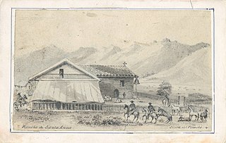
Rancho Santa Ana was a 21,522-acre (87.10 km2) Mexican land grant in present day Ventura County, California given in 1837 by Governor Juan Alvarado to Crisogono Ayala and Cosme Vanegas. Rancho Santa Ana was located inland in the Ventura River Valley on the west side of the Ventura River across from Rancho Ojai which was granted in the same year. Rancho Santa Ana encompassed present day Lake Casitas and Oak View.
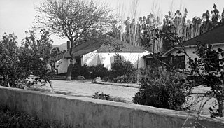
The City of Ventura Historic Landmarks and Districts consist of buildings, sites, and neighborhoods designated by the City of Ventura, California, as historic landmarks and districts.


