Native language of Onufriivka population according to 2001 census
The oldest traces of human existence in the Onufriivka Raion date back to the Neolithic era.
Name
The toponym Onufriivka comes from the surname of the founder. In addition to the name Onufriivka, its modifications were adopted in different periods, in particular "Onokhreevka", "Anofreevka", "Onopryivka".[3]
Foundation
The first documentary mention of the farm (khutir) of a retired Cossack Vasyl Onufrienko dated 1741 in describing Dnipro possessions of Potoky sotnia of Myrhorod Polk (regiment)
Vasyl Onofrey showed that he has a farm on the other side of the Dnipro, on the tract of the Omelnychok river, with hayfields and a plowed field that belonged to it, and a mill and pound on the same river, occupied by him, Onofrey, more than ten years ago.[4].
Later, the farm of the Cossack Onufrienko was mentioned in 1744 in the description of the settlements of the Myrhorod Polk by their owners, in the 1745 description of Daniel de Bosquet, and present on the map of the same author, which was an addition to the description.[5]
Not only the Cossack Onufrienko farm was located on the territory of modern Onufriivka. For example, local historians managed to find the location of Omelian Rozsokha farm, which consisted of "two houses, a dam, a pound, a mill, hay meadows and arable field and an apiary near the Mohyluvata gully". It was located opposite the beam of the Mohyluvata river - the outskirts of Onufriivka, at the end of the Poshtova street. The remains of the dam still remain at this place. In addition to the Rozsokha farm, the researchers managed to establish the approximate location of the Cossack Onufrienko farm at the confluence of Omelnychok and Sukhyi Omelnyk rivers, the farms of the Cossack Andrii Shevchenko and Hrytsko Khystyshyn.[6] Over time these farms merged into one settlement and later existed under one name.
In 1752, with the establishment of military settlements, Onufriivka became part of New Serbia and became the property of Jovan Horvat-Otkurtich. This is confirmed by the 1758 information about persons who moved to housing in the settlements of New Serbia and the Novoslobidsky Cossack Polk, which states that from the Kremenchuk sotnia:
«Mykova Koval; Matviy Shapoval – to the newly settled by his High Excellency Mr. Lieutenant General Horvath settlement, nicknamed Onufreevka» moved[7]
As of 1774, Onufriivka was in state ownership, as evidenced by J. Gindelstaedt in his story about the journey of the Yelysavethrad province:
from the Zybkoe settlement we drove 10 versts straight to N, to the Onokhreevka settlement, a state-owned village of 100 families; all inhabitants are Little Russians (Ukrainians) who came here from both sides of the Dnipro. There is a church in the village, lying on the northern side of the Omelnyk Keleberdiansky river, near the mouth of the Sukhyi Omelnyk[8]
. This church was named after St. Spyrydon as of 1776 and had 50 parish yards.[9]
Since Kremenchuk was the center of the Novorossiya Governorate, the lands around it were a tasty morsel for many noblemen. Onufriivka was no exception. After 1776, it lost the status of the state-owned village and passed into the ownership of Captain Ivan I. Komburley (Konburley), who was a clerk of the Kremenchuk border customs in 1774-1775.[10] The Ivano-Predtechanska Church was built at his expense, in which he was buried together with his wife Feodosia.[11]
The memoirs of Gilbert Romm and Mikhail Zagryazhsky confirm and supplement the information about Onufriivka of that period. In particular, Romm during a trip to the Crimea in 1786 noted:
"…18 versts from Kryukiv there is the village of Onufriivka, which belongs to a private owner, has about 90 houses. A small river Omelnyk flows near it"[12]
In turn, Mikhail Zagryazhsky in his "Notes…" as of 1791 mentioned:
"...Near Kremenchuk I stopped by a former brother in arms, Lieutenant Turunzhe, at whom, because of the need to often be in Kremenchuk, I stopped for several days. We went with him to his neighbor, P. Konburley, who also served with me in the Kharkiv regiment, and his brother - Mikhail Ivanovich on the occasion - ... the village is called Anofreevka, 1000 souls with a significant amount of land are inseparable from his brother ... He lived splendidly at that time and region. He was very happy. He showed all his establishment, beautiful horses and so on..."[13]
After the death of I. Komburley in 1792, Onufriivka was jointly owned by his sons - Mikhail and Pyotr. Mikhail Komburley was once a senator, a real state councilor, Kursk (1798) and Volyn governor (1807-1817), his brother Pyotr was chief of hussar squadrons of Potemkin's convoy in 1789-1791, retired to the reserve in ranks second-major.[14] In addition to Onufriivka, Mikhail Komburley owned neighboring villages: Omelnyk, Ivanivka, Kamburliivka.[15]
After the death of M. Komburley in 1821, his lands, including Onufriivka, passed into the ownership of Mikhail D. Tolstoy, a real state councilor, colonel of the Artillery Guard, chairman of the Imperial Society of Agriculture of Southern Russia. After retiring in 1835, M. Tolstoy settled in Onufriivka, where he lived permanently until 1847.[16] Under Mikhail Dmitrovich, most of Onufriivka Park (the so-called Old Park) was built. It is believed that it was built by German and Czech masters.[17]
After the marriage of Mikhail M. Tolstoy (senior) (1835–1898), son of Mikhail Dmitrievich and Yekaterina Mikhailovna, with Yelena G. Smirnova, Onufriivka became his property. Mikhail Tolstoy (senior) is known primarily for his philanthropic work. He was the director of the Odesa City Theater for a long time, laid the construction of a new building for him and contributed to the development of Onufriivka.[18]
The most progressive period in the history of Onufriivka is connected with the son of Mikhail Tolstoy (senior) and Yelena Smirnova-Tolstoy - Mikhail M. Tolstoy (junior). He inherited from his father about 40 estates in Kherson, Kharkiv and other governorates. Mikhail Mikhailovich held high government positions, he was a court counselor, a member of the Council of the Imperial Society of Agriculture of Southern Russia, a member of the Odesa City Duma, honorary trustee of the Odesa City Public Library, which gave 770 volumes of books and magazines worth about 100 thousand rubles. In addition, M. Tolstoy was the founder and chairman of the Odesa ambulance station, which was the second in the Russian Empire at that time.[19]
Under the leadership of Mikhail Tolstoy (Jr.), the construction of the so-called New Park in Onufriivka began. It is most probable that it was founded in 1884, as evidenced by the inscription "1884" in the nursery in the south of the park.[20] At the expense of Mikhail Mikhailovich, a zemstvo school was built in Onufriivka (there is a letter "T" on some bricks as a marking sign of the Tolstoy brick factory in Onufriivka), and in 1896 a zemstvo hospital was built in the village of Pavlysh, which is 7 km from Onufriivka.[21]
As of 1886, the town, the center of Onufrievka Volost of Aleksandriysky Uyezd of Kherson Governorate, had 1414 people, 254 farmsteads, an Orthodox church, a school, 5 shops, and 3 fairs a year: Seredopisny, Mykilsky on 9 May and Pokrovsky.[22]
Mikhail Tolstoy was a large landowner and introduced advanced methods of management on their lands, used a perfect machinery at that time, iron plows, horse threshers and fans. There was even a Fordzon tractor. Horses of the Orden breed were bred on farms, which were in demand in Russia and abroad. Rambouillet sheep (8,000 heads), gray-Ukrainian cows (600 heads), and sheep wool were sent to Białystok and Łódz cloth factories.
As a result of the revolutionary events of 1917, Onufriivka was left without an owner. In February 1919, the Bolsheviks captured Onufriivka.[23] Mikhail Tolstoy (Jr.) was deprived of the title of count, his estate in Onufriivka was looted by the poor peasants. In addition, Tolstoy was almost shot by Chekists from the Oleksandria uezd Cheka, his life was saved by Onufriivka peasants.[24] In 1919 Mikhail Tolstoy and his mother Yelena Grigoryevna emigrated to Switzerland.
At the end of August 1920 the Bolsheviks were driven out of the village during a raid by the Steppe Division under the command of S. Klepach (Ataman Paliy). Bolshevik reports of the time reported:
"The village of Onufriivka was occupied by bandits, part of the militsiya was captured, part of it retreated. According to unverified information, there are up to 2 thousand bandits in the designated area. In the Pavlysh and Likarivka areas, gangs numbering 1,000 people are operating. 23 volost and 132 rural Kombeds (poor peasants committees) were organized around the uezd, 22 instructors worked. Now the organized work has stopped due to banditry..."[25]
Interbellum
Well-known Ukrainian teacher Vasyl Sukhomlynsky after graduating from September 1939 to June 1941 worked as a teacher of Ukrainian language and literature at Onufriivka Secondary School.
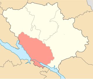
Until 18 July 2020, Onufriivka served as the administrative center of Onufriivka Raion. The raion was abolished in July 2020 as part of the administrative reform of Ukraine, which reduced the number of raions of Kirovohrad Oblast to four. The area of Onufriivka Raion was merged into Oleksandriia Raion.[26][27] On 26 January 2024, a new law entered into force which abolished this status, and Onufriivka became a rural settlement.[28]
Infrastructure
Onufriivka Equestrian Plant
On the territory of the former estate of Counts Tolstoy, the Onufriivka Equestrian Plant № 175 is located[29][30] - a regular participant of the All-Ukrainian and international equestrian sports competitions. Its pupils - horses of purebred English riding - are the Olympic champions, winners of large and small derbies, winners of competitions at the Rostov and Odesa racetracks.
Onufriivka Dendropark, September 2015
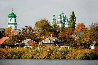
Sights
Dendropark
The Onufriivka Dendropark foundation is connected with the family of Count Tolstoy. One of the students of the famous Russian scientist Dokuchaev supervised the works on the park foundation. All work was performed by the hands of ordinary serfs of Count Tolstoy. The old park dates back to the 1820s, and the new one, south of the Omelnychok River, was planted half a century later. The area of the park is 84 hectares, of which 22 hectares are occupied by water mirror ponds. On its territory there were more than 100 species of trees and shrubs, original gazebos, bridges, small architectural forms, a bulk island with a gazebo and a swimming pool, near the house there were two pools with fountains, a rosary. The alleys of the park were placed according to the classic English model. Peasants were strictly forbidden to enter the lord's park. Only workers cleared the alleys, tended the trees and numerous flower beds, and swans in the park ponds. Later, the peasants were allowed to take water for their needs from one of the ponds. He still kept his name - Peasant pond. The whole park was surrounded by a two-meter brick fence with a decorative lattice.
In 1960, the Council of Ministers of the Ukrainian SSR adopted a resolution according to which the Onufriivka Dendropark was recognized as the 19th century landscape architecture monument.
Count Tolstoy's white dining roomMonument to fellow WWII soldiers
Architecture monuments
Count Tolstoy estate's complex of buildings
Count's white dining room
Manager's house
Forge
Glacier
Carriage shed
School №1
Historical monuments
Mass grave of Soviet soldiers (near the administrative building)
Mass grave of civilians (dendropark)
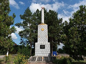
Monument to fellow WWII soldiers (center)
Memorial sign at the place of death of Anatoliy Komar, Soviet WWII military intelligence (road to Pavlysh)
School, where Vasyl Sukhmomlynsky worked
Nature monument
Chestnut
Notable people
The names of Counts Tolstoy - Mikhail (1804 - 1891), his son Mikhail (1834 - 1898), and grandson Mikhail (junior) (1862 - 1927) are closely connected with the region. The counts owned 13,000 acres of land and surrounding villages. All of them were engaged in charitable activities and patronage, introduced advanced technologies in agriculture. The foundation of the Onufriivka Dendropark is associated with the name of Mykhail Tolstoy. Mikhail (senior) developed the estate. Mikhail Mykhailovych (junior) built a school in Onufriivka and Pavlysh, a hospital in Pavlysh, a veterinary hospital in Onufriivka, and other social facilities at his own expense; completed the construction of the Onufriivka Dendropark. Counts Tolstoy were prominent philanthropists and patrons of his time. An ambulance station was built in Odesa at the expense of Mykhailo Mykhailovych. Each of the counts was the schools for children from poor families trustees. The counts made a huge contribution to the development of agriculture and viticulture in southern Russia. After the October Revolution, the life of the last Count Tolstoy was tragic. Deprived of all his property, the seriously ill Mikhail Tolstoy and his mother, Elena, left for Geneva. That's where his life ended (30 August 1927). With his death, one of the branches of the glorious Tolstoy family broke off.
Related Research Articles
Dnipropetrovsk Oblast, is an oblast (province) in simultaneously southern, eastern and central Ukraine, the most important industrial region of the country. It was created on February 27, 1932. Dnipropetrovsk Oblast has a population of about 3,096,485, approximately 80% of whom live centering on administrative centers: Dnipro, Kryvyi Rih, Kamianske, Nikopol and Pavlohrad. The Dnieper River runs through the oblast.
Baturyn is a historic city in Chernihiv Oblast (province) of northern Ukraine. It is located in Nizhyn Raion (district) on the banks of the Seym River. It hosts the administration of Baturyn urban hromada, one of the hromadas of Ukraine. Population: 2,406.
Oleksandriia is a city in Kirovohrad Oblast, central Ukraine. It serves as the administrative center of Oleksandriia Raion. It also hosts the administration of Oleksandriia urban hromada, one of the hromadas of Ukraine. Oleksandriia is located within the Kryvyi Rih metropolitan area.
Novomoskovsk is a city and municipality in Dnipropetrovsk Oblast, Ukraine. It serves as the administrative center of Novomoskovsk Raion within the oblast. Novomoskovsk is located predominantly on the right bank of the Samara River, a left tributary of the Dnieper River. The city is located 27 kilometres (17 mi) from the administrative center of the oblast, Dnipro. As of January 2022, Novomoskovsk's population was approximately 69,855.
Voznesensk is a city in Mykolaiv Oblast, Ukraine. It serves as the administrative center of Voznesensk Raion within the oblast. It hosts the administration of the Voznesensk urban hromada. The city has a population of 33,442.
Znamianka is a city in central Ukraine, Kropyvnytskyi Raion, Kirovohrad Oblast. It hosts the administration of Znamianka urban hromada, one of the hromadas of Ukraine. Population: 21,221.
Oleksandriia Raion is a raion (district) of Kirovohrad Oblast in central Ukraine. The administrative center of the raion is the city of Oleksandriia, which is incorporated separately as a city of oblast significance and does not belong to the raion. Population: 219,482.
Onufriivka Raion was a raion of Kirovohrad Oblast in central Ukraine. Its administrative center was the urban-type settlement of Onufriivka. The raion was abolished on 18 July 2020 as part of the administrative reform of Ukraine, which reduced the number of raions of Kirovohrad Oblast to four. The area of Onufriivka Raion was merged into Oleksandriia Raion. The last estimated population was 17,250.
Kremenchuk Raion is a raion (district) in Poltava Oblast, central Ukraine. The raion's administrative center is the city of Kremenchuk. Population: 387,200.
Novorossiya Governorate was an administrative-territorial unit (guberniya) of the Russian Empire, which existed in 1764–1783 and again in 1796–1802. It was created and governed according to the "Plan for the Colonization of New Russia Governorate" issued by the Russian Senate. It became the first region in Russia where Catherine the Great allowed foreign Jews to settle.
Kirovohrad Oblast is subdivided into districts (raions) which are subdivided into territorial communities (hromadas).
Arbuzynka is a rural settlement in Pervomaisk Raion in the north of Mykolaiv Oblast, Ukraine. It hosts the administration of Arbuzynka settlement hromada, one of the hromadas of Ukraine. Population: 5,954.
Petrove is a rural settlement in Oleksandriia Raion of Kirovohrad Oblast (region) of Ukraine. It hosts the administration of Petrove settlement hromada, one of the hromadas of Ukraine. Population: 6,914 .
Lykhivka is a rural settlement in Kamianske Raion, Dnipropetrovsk Oblast, Ukraine. It is located in the northwest of the oblast, on the banks of the Omelnyk, a right tributary of the Dnieper. Lykhivka hosts the administration of Lykhivka settlement hromada, one of the hromadas of Ukraine. Population: 1,822.
Bilyky is a rural settlement in Poltava Raion, Poltava Oblast, Ukraine. It is located on the right bank of the Vorskla, a left tributary of the Dnieper. Bilyky hosts the administration of Bilyky settlement hromada, one of the hromadas of Ukraine. Population: 4,736.
Pavlysh is a rural settlement in Oleksandriia Raion of Kirovohrad Oblast in Ukraine. It is located on the banks of the Omelnyk, a right tributary of the Dnieper. Pavlysh belongs to Onufriivka settlement hromada, one of the hromadas of Ukraine. Population: 4,509.
Pryiutivka is a rural settlement in Oleksandriia Raion of Kirovohrad Oblast in Ukraine. It is located on the banks of the Inhulets, a right tributary of the Dnieper, and is adjacent to the city of Oleksandriia. Pryiutivka hosts the administration of Pryiutivka settlement hromada, one of the hromadas of Ukraine. Population: 3,045.
Pantaivka is a rural settlement in Oleksandriia Raion of Kirovohrad Oblast in Ukraine. It is located in the steppe, about 10 kilometres (6.2 mi) west of the city of Oleksandriia. Pantaivka hosts the administration of Pantaivka settlement hromada, one of the hromadas of Ukraine. Population: 2,536.
Vlasivka is a rural settlement in Oleksandriia Raion of Kirovohrad Oblast in Ukraine. It is located on the left bank of the Dnieper next to the Kremenchuk Hydroelectric Power Plant and close to the city of Kremenchuk. This is the only locality in Kirovohrad Oblast on the left bank of the Dnieper. Vlasivka belongs to Svitlovodsk urban hromada, one of the hromadas of Ukraine. Population: 7,258.
↑ Ya. Ivanov.Оnufriivka // Hardarika: Materials of the All-Ukrainian Competition of Popular Science Articles .— Kharkiv.: Pravo, 2015.— p. 71
↑ A. Pyvovar; Settlements of Dnipro Places Before the Formation of New Serbia in the Documents of the XVIIICentury.— Кyiv: Akademperiodyka, 2003.— p. 147
↑ A. Pyvovar; Settlements of Dnipro Places Before the Formation of New Serbia in the Documents of the XVIIICentury.— Кyiv: Akademperiodyka, 2003.— p. 179, 187
↑ V. Postryhan, V. Surmylo; History of Onufriivka Raion— Kremenchuk, 2010.— p. 44
↑ A. Pyvovar; Settlements of Dnipro Places Before the Formation of New Serbia in the Documents of the XVIIICentury.— Кyiv: Akademperiodyka, 2003.— p. 243
↑ Johan-Anton GindelstaedtJourney Through the Yelysavethrad Province in 1774;— Кyiv: Akademperiоdyka, 2005.— p. 41
↑ Orthodox Church In the South of Ukraine (1775 – 1781) / Complier: I. Lyman. // Sources From History of South of Ukraine. Volume 4.— Zaporіzhzhia.: RA «Tandem-U», 2004.— p. 152
↑ A. Makidonov; The Personal Composition of the Administrative Apparatus of Novorosiya In the 18th Century;— Zaporizhzhia: Prosvita, 2011.— p. 24
↑ V. Postryhan, V. Surmylo; History of Onufriivka Raion— Kremenchuk, 2010.— p. 59
↑ Gilbert Romm. Journey to the Crimea in 1786.— Leningrad: Leningrad State University Edition, 1941.— p. 22
↑ M. Zagryazhsky. Notes // Faces. Biographical Almanac. 2nd edition.— Moscow; Saint-Petersburg, 1993.— p. 118
↑ V. Postryhan, V. Surmylo; History of Onufriivka Raion— Kremenchuk, 2010.— p. 59
↑ Alphabet For Dachas of the General Survey of the Alexandriysky Uyezd, Kherson Governorate— Oleksandriia: F. Raichelson's Printing House, 1898.— p. 50
↑ V. Postryhan, V. Surmylo; History of Onufriivka Raion— Kremenchuk, 2010.— p. 66
↑ V. Postryhan, V. Surmylo; History of Onufriivka Raion— Kremenchuk, 2010.— p. 71
↑ V. Postryhan, V. Surmylo; History of Onufriivka Raion— Kremenchuk, 2010.— p. 67
↑ V. Postryhan, V. Surmylo; History of Onufriivka Raion— Kremenchuk, 2010.— p. 66-67
↑ V. Postryhan, V. Surmylo; History of Onufriivka Raion— Kremenchuk, 2010.— p. 71
↑ V. Postryhan, V. Surmylo; History of Onufriivka Raion— Kremenchuk, 2010.— p. 75
↑ Волости и важнейшие селения Европейской России[The Most Important Towns and Villages in European Russia] (in Russian). Vol.VIII. St. Petersburg: Центр. статист. комитет. 1886.
↑ History of Cities And Villages of Ukrainian SSR. Kirovohrad Oblast.— Кyiv: Institute of History of Ukrainian SSR Academy of Science, 1972— p. 649
↑ V. Postryhan, V. Surmylo; History of Onufriivka Raion— Kremenchuk, 2010.— p. 68-69
This page is based on this Wikipedia article Text is available under the CC BY-SA 4.0 license; additional terms may apply. Images, videos and audio are available under their respective licenses.