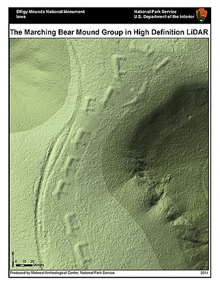
Operation IceBridge

Last updated
The NASA DC-8 sits on the Punta Arenas airport ramp during pre-flight procedures during the 2012 Antarctic campaign NASA DC-8 Punta Arenas Antarctic 2012.jpg
The NASA DC-8 sits on the Punta Arenas airport ramp during pre-flight procedures during the 2012 Antarctic campaign
Bruckner and Heim Gletschers pouring into Johan Petersens Fjord in eastern coastal Greenland. Taken from the NASA HU-25C Falcon aircraft, September 2016. 20160902 MG 0510 adj2 40pcnt.jpg
Bruckner and Heim Gletschers pouring into Johan Petersens Fjord in eastern coastal Greenland. Taken from the NASA HU-25C Falcon aircraft, September 2016.

Operation IceBridge (OIB) was a NASA mission to monitor changes in polar ice. It is an airborne follow-on mission to the ICESat satellite, until after the ICESat-2 mission was launched in September 2018. OIB ended in 2019.

Contents

Program history

From 2003 to 2009, NASA used a space-based laser altimeter, ICESat, for observing polar ice. ICESat was retired in 2009 due to a technical malfunction, leaving NASA without a satellite dedicated to ice observance. A next-generation satellite, ICESat-2, launched in September 2018. [1] [2] [3] In order to maintain annual observations of ice sheets and sea ice, NASA introduced the IceBridge program to "bridge the gap" between satellite missions. The program utilizes aircraft platforms to make airborne measurements of the polar regions.

IceBridge flights began in March 2009, [4] on an Arctic Spring campaign based out of Thule Air Base, Greenland. Southern Hemisphere flights began during the first Austral Spring campaign in October 2009, based out of Punta Arenas, Chile. Flights during field campaigns can contain either dedicated land ice and sea ice flights, or a combination thereof, based upon platform, weather and location constraints. To date there have been Spring campaigns in the Arctic and Antarctic, as well as flights monitoring summer melt on Alaskan glaciers every year since 2009. Additional campaigns have occurred in the Arctic summer and East Antarctica.

Platforms

The P-3 Orion aircraft used in Operation IceBridge P-3 Orion NASA ICE Bridge Airplane.jpg
The P-3 Orion aircraft used in Operation IceBridge

IceBridge flights began in March 2009 using a Lockheed P-3 Orion in the Arctic, and were followed later that year by a Douglas DC-8 in the Antarctic. Other aircraft have been used throughout the program, such as a King Air B-200, Gulfstream V and Guardian Falcon. [5]

There are tradeoffs to using an aircraft instead of a satellite. One drawback is that a satellite can observe a far wider area. Also, satellites take measurements full-time, while IceBridge aircraft measurements are limited to annual campaigns that are several weeks long. Aircraft, however, have the advantage of being able to carry more instruments, change or upgrade instruments from campaign to campaign and target scientifically interesting areas instead of following a fixed path. Also, certain instruments such as ice-penetrating radar only work from the lower altitudes afforded by aircraft like the P-3 Orion and DC-8. [2] [5]

Instruments

The bedrock topography of Antarctica, critical to understand dynamic motion of the continental ice sheets. AA bedrock bedmap2.4960.tif
The bedrock topography of Antarctica, critical to understand dynamic motion of the continental ice sheets.
Visualization of NASA's mission Operation IceBridge dataset BEDMAP2, obtained with laser and ice-penetrating radar, collecting surface height, bedrock topography and ice thickness. AA bedrock surface.4960.tif
Visualization of NASA's mission Operation IceBridge dataset BEDMAP2, obtained with laser and ice-penetrating radar, collecting surface height, bedrock topography and ice thickness.

IceBridge aircraft carry a suite of specialized science instruments. Among these is the Airborne Topographic Mapper, a laser that measures the surface elevation of the ice. Also on board is a gravimeter, an instrument capable of measuring the shape of cavities in the ice. There are numerous other pieces of equipment on board, including the Land, Vegetation and Ice Sensor, the Multichannel Coherent Radar Depth Sounder, a Snow Radar, a Ku-Band Radar Altimeter, a magnetometer and the Digital Mapping System. [5]

Laser altimeters

Airborne Topographic Mapper (ATM) – The Airborne Topographic Mapper (ATM) is a laser altimeter that bounces laser light off the ice surface and measures how long it takes to return. By combining this timing data with information about the aircraft's position and attitude, researchers can calculate ice elevation. By flying over the same areas of ice year after year, they can build a time series of changes in elevation. This instrument works similarly to the lidar instrument used in ICESat and is helping maintain a record of elevation changes until ICESat-2 becomes operational. [6]

Land Vegetation and Ice Sensor (LVIS) - The Land, Vegetation and Ice Sensor (LVIS) is a laser altimeter optimized for operation at higher altitudes. LVIS was created by scientists at the Laser Remote Sensing Laboratory at NASA's Goddard Space Flight Center. LVIS has flown on a wide variety of aircraft such as NASA's P-3, DC-8, B-200 and HU-25C Guardian Falcon and NSF's Gulfstream G-V. By flying at a higher altitude, LVIS can survey larger areas and expands IceBridge's range. [7]

Radars

Operation IceBridge uses up to four different radar instruments operated by the Center for the Remote Sensing of Ice Sheets (CReSIS) at the University of Kansas. Indiana University provides data management services for CReSIS activities in Operation IceBridge. [8]

Multichannel Coherent Radar Depth Sounder (MCoRDS) - The Multichannel Coherent Radar Depth Sounder (MCoRDS) is used to measure ice thickness and map beneath the ice. This instrument uses multiple channels and a large range of radar frequencies to image internal ice layering and bedrock beneath ice sheets. Information on sub-ice terrain is useful for modeling ice sheets. [9]

Snow Radar - The CReSIS Snow Radar instrument is used to measure the thickness of snow layers on top of land and sea ice. Measuring snow thickness is crucial for estimating sea ice thickness. [10]

Ku-band Radar Altimeter - IceBridge also carries a Ku band radar altimeter, which can penetrate snow layers to measure sea and land ice surface elevation. [11]

Accumulation Radar - The accumulation radar instrument is used to gather high-resolution data on the top part of ice. Looking at the uppermost part of ice allows researchers to map past snow accumulation rates. [12]

Mapping instruments

Digital Mapping System (DMS) - The Digital Mapping System (DMS), created by researchers at NASA's Ames Research Center, is an airborne digital imaging system that is used to detect openings in sea ice and build high-resolution maps of polar ice. The DMS instrument is a downward-facing digital camera that captures multiple individual frames that are combined into image mosaics using computer software. [13]

Gravimeter - Operation IceBridge also uses a gravity-measuring instrument known as a gravimeter. This instrument measures the strength of gravitational fields beneath the aircraft, which researchers can use to determine the shape of water cavities beneath floating ice shelves. Because water is less dense than rock, areas of floating ice show weaker gravitational fields than areas with rock underneath. [14]

Magnetometer - The NASA P-3 Orion carries a magnetometer that can be used to gather data on the properties of sub-ice rock. Density and magnetic properties can be used to infer bedrock type, which is helpful for determining sub-ice basal conditions. [15]

Research

Aerial photo of Pine Island Glacier taken during Operation IceBridge ICE bridge Antarctic Sea Ice.JPG
Aerial photo of Pine Island Glacier taken during Operation IceBridge

The project, headed by project scientist Joseph MacGregor, from NASA's Goddard Space Flight Center, uses a suite of airborne science instruments to get a three-dimensional view of Arctic and Antarctic ice. [16] The mission's goals are to monitor changes in polar ice, gather data for predictive models of ice and sea-level rise and bridge the gap in measurements between NASA's ICESat and ICESat-2 satellites. IceBridge achieves this by collecting data over ice sheets, glaciers and sea ice. Pine Island Glacier is one such area of focus. There, Operation IceBridge has been observing the underside of the ice-sheet using an advanced radar, as well as closely monitoring an area of Pine Island Glacier known as the ice tongue that, were it to melt, would allow a large portion of the glacier to slide into the Amundsen Sea. [2]

In August 2013 the discovery of the longest canyon on Earth under the Greenland ice sheet was reported, based on an analysis of data from Operation IceBridge. [17]

Outreach and collaborations

For the second straight year, NASA's Operation IceBridge is collaborating with the European Space Agency's CryoVEx program, flying aircraft low over Arctic sea ice while ESA's CryoSat satellite orbits above. In this video, IceBridge Project Scientist Michael Studinger discusses the benefits of the long term joint data set the agencies are creating.
In 2012, five teachers were invited on board NASA's P-3B aircraft to fly at 500 metres (1,600 ft) above the glaciers of Greenland with Operation IceBridge.

Related Research Articles

<span class="mw-page-title-main">Altimeter</span> Instrument used to determine the height of an object above a certain point

An altimeter or an altitude meter is an instrument used to measure the altitude of an object above a fixed level. The measurement of altitude is called altimetry, which is related to the term bathymetry, the measurement of depth under water.

<span class="mw-page-title-main">Digital elevation model</span> 3D computer-generated imagery and measurements of terrain

A digital elevation model (DEM) or digital surface model (DSM) is a 3D computer graphics representation of elevation data to represent terrain or overlaying objects, commonly of a planet, moon, or asteroid. A "global DEM" refers to a discrete global grid. DEMs are used often in geographic information systems (GIS), and are the most common basis for digitally produced relief maps. A digital terrain model (DTM) represents specifically the ground surface while DEM and DSM may represent tree top canopy or building roofs.

<span class="mw-page-title-main">Satellite geodesy</span> Measurement of the Earth using satellites

Satellite geodesy is geodesy by means of artificial satellites—the measurement of the form and dimensions of Earth, the location of objects on its surface and the figure of the Earth's gravity field by means of artificial satellite techniques. It belongs to the broader field of space geodesy. Traditional astronomical geodesy is not commonly considered a part of satellite geodesy, although there is considerable overlap between the techniques.

<span class="mw-page-title-main">Space-based radar</span> Use of radar systems mounted on satellites

Space-based radar or spaceborne radar is a radar operating in outer space; orbiting radar is a radar in orbit and Earth orbiting radar is a radar in geocentric orbit. A number of Earth-observing satellites, such as RADARSAT, have employed synthetic aperture radar (SAR) to obtain terrain and land-cover information about the Earth.

<span class="mw-page-title-main">TOPEX/Poseidon</span> Satellite mission to map ocean surface topography

TOPEX/Poseidon was a joint satellite altimeter mission between NASA, the U.S. space agency; and CNES, the French space agency, to map ocean surface topography. Launched on August 10, 1992, it was the first major oceanographic research satellite. TOPEX/Poseidon helped revolutionize oceanography by providing data previously impossible to obtain. Oceanographer Walter Munk described TOPEX/Poseidon as "the most successful ocean experiment of all time." A malfunction ended normal satellite operations in January 2006.

CryoSat is an ESA programme to monitor variations in the extent and thickness of polar ice through use of a satellite in low Earth orbit. The information provided about the behaviour of coastal glaciers that drain thinning ice sheets will be key to better predictions of future sea level rise. The CryoSat-1 spacecraft was lost in a launch failure in 2005, however the programme was resumed with the successful launch of a replacement, CryoSat-2, launched on 8 April 2010.

<span class="mw-page-title-main">ICESat</span> NASA satellite to observe ice sheets, clouds, and land; 2003–2010

ICESat was a NASA satellite mission for measuring ice sheet mass balance, cloud and aerosol heights, as well as land topography and vegetation characteristics. It operated as part of NASA's Earth Observing System (EOS). ICESat was launched 13 January 2003 on a Delta II launch vehicle from Vandenberg Air Force Base in California into a near-circular, near-polar orbit with an altitude of approximately 600 km (370 mi). It operated for seven years before being retired in February 2010, after its scientific payload shut down and scientists were unable to restart it.

<span class="mw-page-title-main">OSTM/Jason-2</span> International Earth observation satellite mission

OSTM/Jason-2, or Ocean Surface Topography Mission/Jason-2 satellite, was an international Earth observation satellite altimeter joint mission for sea surface height measurements between NASA and CNES. It was the third satellite in a series started in 1992 by the NASA/CNES TOPEX/Poseidon mission and continued by the NASA/CNES Jason-1 mission launched in 2001.

<span class="mw-page-title-main">Lunar Reconnaissance Orbiter</span> NASA robotic spacecraft orbiting the Moon

The Lunar Reconnaissance Orbiter (LRO) is a NASA robotic spacecraft currently orbiting the Moon in an eccentric polar mapping orbit. Data collected by LRO have been described as essential for planning NASA's future human and robotic missions to the Moon. Its detailed mapping program is identifying safe landing sites, locating potential resources on the Moon, characterizing the radiation environment, and demonstrating new technologies.

<span class="mw-page-title-main">Sentinel-3</span> Earth observation satellite series

Sentinel-3 is an Earth observation heavy satellite series developed by the European Space Agency as part of the Copernicus Programme. It currently consists of 2 satellites: Sentinel-3A and Sentinel-3B. After initial commissioning, each satellite was handed over to EUMETSAT for the routine operations phase of the mission. Two recurrent satellites— Sentinel-3C and Sentinel-3D— will follow in approximately 2025 and 2028 respectively to ensure continuity of the Sentinel-3 mission.

<span class="mw-page-title-main">CryoSat-2</span> European Space Agency environmental research satellite

CryoSat-2 is a European Space Agency (ESA) Earth Explorer Mission that launched on April 8, 2010. CryoSat-2 is dedicated to measuring polar sea ice thickness and monitoring changes in ice sheets. Its primary objective is to measure the thinning of Arctic sea ice, but has applications to other regions and scientific purposes, such as Antarctica and oceanography.

<span class="mw-page-title-main">Measurement of sea ice</span> Records made for navigational safety and environmental monitoring

Measurement of sea ice is important for safety of navigation and for monitoring the environment, particularly the climate. Sea ice extent interacts with large climate patterns such as the North Atlantic oscillation and Atlantic Multidecadal Oscillation, to name just two, and influences climate in the rest of the globe.

<span class="mw-page-title-main">SARAL</span> Indian Earth observation satellite

SARAL is a cooperative altimetry technology mission of Indian Space Research Organisation (ISRO) and Centre National d'Études Spatiales (CNES). SARAL performs altimetric measurements designed to study ocean circulation and sea surface elevation.

<span class="mw-page-title-main">CryoSat-1</span> ESA satellite to study polar ice; lost in launch failure in 2005

CryoSat-1, also known as just CryoSat, was a European Space Agency satellite which was lost in a launch failure in 2005. The satellite was launched as part of the European Space Agency's CryoSat mission, which aims to monitor ice in the high latitudes. The second mission satellite, CryoSat-2, was successfully launched in April 2010.

Sea ice thickness spatial extent, and open water within sea ice packs can vary rapidly in response to weather and climate. Sea ice concentration are measured by satellites, with the Special Sensor Microwave Imager / Sounder (SSMIS), and the European Space Agency's Cryosat-2 satellite to map the thickness and shape of the Earth's polar ice cover. The sea ice volume is calculated with the Pan-Arctic Ice Ocean Modeling and Assimilation System (PIOMAS), which blends satellite-observed data, such as sea ice concentrations into model calculations to estimate sea ice thickness and volume. Sea ice thickness determines a number of important fluxes such as heat flux between the air and ocean surface—see below—as well as salt and fresh water fluxes between the ocean since saline water ejects much of its salt content when frozen—see sea ice growth processes. It is also important for navigators on icebreakers since there is an upper limit to the thickness of ice any ship can sail through.

ICESat-2, part of NASA's Earth Observing System, is a satellite mission for measuring ice sheet elevation and sea ice thickness, as well as land topography, vegetation characteristics, and clouds. ICESat-2, a follow-on to the ICESat mission, was launched on 15 September 2018 onboard Delta II as the final flight from Vandenberg Air Force Base in California, into a near-circular, near-polar orbit with an altitude of approximately 496 km (308 mi). It was designed to operate for three years and carry enough propellant for seven years. The satellite orbits Earth at a speed of 6.9 kilometers per second (4.3 mi/s).

<span class="mw-page-title-main">GEOS-3</span> Satellite

GEOS-3, or Geodynamics Experimental Ocean Satellite 3, or GEOS-C, was the third and final satellite as part of NASA's Geodetic Earth Orbiting Satellite/Geodynamics Experimental Ocean Satellite program (NGSP) to better understand and test satellite tracking systems. For GEOS 1 and GEOS 2, the acronym stands for Geodetic Earth Orbiting Satellite; this was changed for GEOS-3.

Helen Amanda Fricker is a glaciologist and professor at Scripps Institution of Oceanography at the University of California, San Diego where she is a director of the Scripps Polar Center. She won the 2010 Martha T. Muse Prize for Science and Policy in Antarctica.

<span class="mw-page-title-main">Sentinel-6 Michael Freilich</span> Earth observation satellite

The Sentinel-6 Michael Freilich (S6MF) or Sentinel-6A is a radar altimeter satellite developed in partnership between several European and American organizations. It is part of the Jason satellite series and is named after Michael Freilich. S6MF includes synthetic-aperture radar altimetry techniques to improve ocean topography measurements, in addition to rivers and lakes. The spacecraft entered service in mid 2021 and is expected to operate for 5.5 years.

Sinéad Louise Farrell is a British-American space scientist who is Professor of Geographic Sciences at the University of Maryland, College Park. Her research considers remote sensing and climate monitoring. She was science lead for the ICESat-2 Mission, which used laser altimetry to make height maps of Earth.

References

  1. "NASA's Successful Ice Cloud and Land Elevation Mission Comes to an End". NASA. 27 August 2010. Retrieved 31 August 2010.
  2. 1 2 3 Hamilton, John (30 October 2009). "NASA Launches Mission To Track Polar Ice By Plane". NPR . Retrieved 25 February 2011.
  3. Ramsayer, Kate (15 March 2017). "NASA's ICESat-2 to Provide More Depth to Sea Ice Forecasts". NASA.
  4. "NASA IceBridge Campaigns". NASA. Retrieved 20 June 2018.
  5. 1 2 3 "IceBridge Aircraft & Instruments". NASA. Retrieved 26 December 2012.
  6. "Airborne Topographic Mapper (ATM)". NASA. Retrieved 26 December 2012.
  7. "Land, Vegetation and Ice Sensor (LVIS)". NASA. Retrieved 26 December 2012.
  8. Bertolucci, Jeff (13 May 2013). "NASA Polar Ice Flyover: One Bumpy Big Data Project". InformationWeek . Retrieved 22 May 2013.
  9. "Multichannel Coherent Radar Depth Sounder (MCoRDS)". NASA. Retrieved 28 December 2012.
  10. "Snow Radar". NASA. Retrieved 28 December 2012.
  11. "Ku-band Radar Altimeter". NASA. Retrieved 28 December 2012.
  12. "Accumulation Radar". NASA. Retrieved 28 December 2012.
  13. "Digital Mapping System (DMS)". NASA. Retrieved 28 December 2012.
  14. "Gravimeter". NASA. Retrieved 28 December 2012.
  15. "Magnetometer". NASA. Retrieved 28 December 2012.
  16. "Operation IceBridge home page". NASA. Retrieved 26 December 2012.
  17. Oskin, Becky (30 August 2013). "Grand Canyon of Greenland Discovered under Ice". Livescience.