Oregon Trunk Rail Bridge

Last updated
Oregon Trunk Bridge
OregonTrunkRailBridge1.jpg
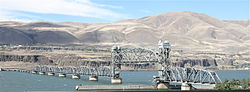
Viewed from the southwest
Coordinates 45°38′56.2″N120°58′54.3″W / 45.648944°N 120.981750°W / 45.648944; -120.981750
Carries1 railroad track of BNSF Railway
Crosses Columbia River
Locale Oregon Trunk Junction, Oregon (in Wasco County);
Wishram, Washington
Characteristics
Design Pratt truss with swing span (inoperable) and
vertical-lift span (operational)
Total lengthapprox. 2,400–3,350 feet
Longest spanapprox. 300 feet
History
OpenedJanuary 1912 [1]
Location
Oregon Trunk Rail Bridge

The Oregon Trunk Rail Bridge or Celilo Bridge [1] is a single-track railroad bridge opened in 1912 [2] over the Columbia River in the Pacific Northwest of the United States. It consists of eight steel truss spans and several deck girder spans, and since 1957 it has included a vertical-lift section. The bridge was designed by engineer Ralph Modjeski and erected by the Missouri Valley Bridge & Iron Co., of Leavenworth, Kansas. [1]

Contents

It is part of the Wishram, Washington to Bend, Oregon line of the BNSF Railway (formerly the Oregon Trunk line of the Spokane, Portland and Seattle Railway). The bridge is downstream of the site of Celilo Falls, now submerged by water impounded by The Dalles Dam. The Celilo Canal passed beneath the southernmost span, which was a swing span. Completion of The Dalles Dam in 1957 inundated the canal. Over a period of several months starting in October 1956, the bridge was raised by up to 5 feet (1.5 m) over its entire length, and the truss span to the north of the swing span was modified to a vertical-lift-type span for river navigation. The new lift span's first complete raising and lowering took place on June 21, 1957, and the bridge reopened to rail traffic the following day. [3] The swing span, to the south of the lift span, remains in place, but it ceased to be used after the lift span was installed. It was "permanently locked in place" in October 1956, for the start of work to modify the bridge. [4]

View from the southeast, showing both the original swing span (at left) and the vertical-lift span added in 1957 Oregon Trunk railroad bridge lift span and former swing span, viewed from southeast.jpg
View from the southeast, showing both the original swing span (at left) and the vertical-lift span added in 1957
The lift span in the lowered position, the less common position Oregon Trunk Rail Bridge, lift span down - viewed from the northeast.jpg
The lift span in the lowered position, the less common position

All of the bridge's piers rest on rocks that were normally exposed during low water periods. During periods of high water, this stretch of the Columbia River became raging rapids, so the piers were built during low water. The north end of the bridge is a wye, where the rail line from Bend meets the BNSF Portland to Pasco mainline. On the south end of the bridge, the line crosses over and interchanges with the Union Pacific mainline. Excluding the two branches at the north end, the bridge is 2,396 feet (730 m) long. The wye's east leg is 952 feet (290 m) long, and its west leg 849 feet (259 m) long. [1]

When built, the bridge's longest span was a 316-foot (96 m) fixed span located just to the north of the swing span; [1] that section was later replaced by a lift span.

See also

Related Research Articles

Dallesport, Washington Census-designated place in Washington, United States

Dallesport is an unincorporated community and census-designated place (CDP) in Klickitat County, Washington, United States. The population was 1,202 at the 2010 census.

Wishram, Washington Census-designated place in Washington, United States

Wishram is an unincorporated community and census-designated place (CDP) in Klickitat County, Washington, United States. The population was 342 at the 2010 census, up from 213 at the 2000 census. The site of the historic Celilo Falls is nearby.

Columbia River Gorge

The Columbia River Gorge is a canyon of the Columbia River in the Pacific Northwest of the United States. Up to 4,000 feet (1,200 m) deep, the canyon stretches for over eighty miles (130 km) as the river winds westward through the Cascade Range, forming the boundary between the state of Washington to the north and Oregon to the south. Extending roughly from the confluence of the Columbia with the Deschutes River in the east down to the eastern reaches of the Portland metropolitan area, the water gap furnishes the only navigable route through the Cascades and the only water connection between the Columbia Plateau and the Pacific Ocean. It is thus the route of Interstate 84, U.S. Route 30, Washington State Route 14, and railroad tracks on both sides.

Steel Bridge Bridge in Portland, Oregon

The Steel Bridge is a through truss, double-deck vertical-lift bridge across the Willamette River in Portland, Oregon, United States, opened in 1912. Its lower deck carries railroad and bicycle/pedestrian traffic, while the upper deck carries road traffic, and light rail (MAX), making the bridge one of the most multimodal in the world. It is the only double-deck bridge with independent lifts in the world and the second oldest vertical-lift bridge in North America, after the nearby Hawthorne Bridge. The bridge links the Rose Quarter and Lloyd District in the east to Old Town Chinatown neighborhood in the west.

Hawthorne Bridge

The Hawthorne Bridge is a truss bridge with a vertical lift that spans the Willamette River in Portland, Oregon, joining Hawthorne Boulevard and Madison Street. It is the oldest vertical-lift bridge in operation in the United States and the oldest highway bridge in Portland. It is also the busiest bicycle and transit bridge in Oregon, with over 8,000 cyclists and 800 TriMet buses daily. It was added to the National Register of Historic Places in November 2012.

Swing bridge

A swing bridge is a movable bridge that has as its primary structural support a vertical locating pin and support ring, usually at or near to its center of gravity, about which the turning span can then pivot horizontally as shown in the animated illustration to the right. Small swing bridges as found over canals may be pivoted only at one end, opening as would a gate, but require substantial underground structure to support the pivot.

The Dalles Dam Dam in Klickitat County, Washington / Wasco County, Oregon, USA

The Dalles Dam is a concrete-gravity run-of-the-river dam spanning the Columbia River, two miles (3 km) east of the city of The Dalles, Oregon, United States. It joins Wasco County, Oregon with Klickitat County, Washington, 192 miles (309 km) upriver from the mouth of the Columbia near Astoria, Oregon. The closest towns on the Washington side are Dallesport and Wishram.

Interstate Bridge

The Interstate Bridge is a pair of nearly identical steel vertical-lift, "Parker type" through-truss bridges that carry Interstate 5 traffic over the Columbia River between Vancouver, Washington and Portland, Oregon in the United States.

Burlington Northern Railroad Bridge 5.1

The Burlington Northern Railroad Bridge 5.1 or BNSF Railway Bridge 5.1, also known as the St. Johns Railroad Bridge or the Willamette River Railroad Bridge, is a through truss railway bridge with a vertical lift that spans the Willamette River in Portland, Oregon, United States. Built by the Spokane, Portland and Seattle Railway (SP&S) and completed in 1908, it was originally a swing-span bridge, and its swing-span section was the longest in the world at the time. However, 81 years later the main span was converted from a swing-type to a vertical-lift type, in order to widen the navigation channel. The lift span is one of the highest and longest in the world. The bridge consists of five sections, with the two sections closest to the bank on each side fixed.

Celilo Falls Waterfall in Washington (state), United States

Celilo Falls was a tribal fishing area on the Columbia River, just east of the Cascade Mountains, on what is today the border between the U.S. states of Oregon and Washington. The name refers to a series of cascades and waterfalls on the river, as well as to the native settlements and trading villages that existed there in various configurations for 15,000 years. Celilo was the oldest continuously inhabited community on the North American continent until 1957, when the falls and nearby settlements were submerged by the construction of The Dalles Dam.

Harlem River Lift Bridge Bridge between Manhattan and the Bronx, New York

The Harlem River Lift Bridge is a vertical lift bridge carrying the Metro-North Railroad's Hudson Line, Harlem Line, and New Haven Line across the Harlem River between the boroughs of Manhattan and the Bronx in New York City. The average weekday ridership on the lines is 265,000.

Burlington Northern Railroad Bridge 9.6

Burlington Northern Railroad Bridge 9.6 or BNSF Railway Bridge 9.6, also known as the Columbia River Railroad Bridge, is through truss railway bridge across the Columbia River, between Portland, Oregon, and Vancouver, Washington, owned and operated by BNSF Railway. Built by the Spokane, Portland and Seattle Railway (SP&S) and completed in 1908, it was the first bridge of any kind to be built across the lower Columbia River, preceding the first road bridge, the nearby Interstate Bridge, by a little more than eight years.

Steamboats of the Columbia River

Many steamboats operated on the Columbia River and its tributaries, in the Pacific Northwest region of North America, from about 1850 to 1981. Major tributaries of the Columbia that formed steamboat routes included the Willamette and Snake rivers. Navigation was impractical between the Snake River and the Canada–US border, due to several rapids, but steamboats also operated along the Wenatchee Reach of the Columbia, in northern Washington, and on the Arrow Lakes of southern British Columbia.

Cascade Locks and Canal United States historic place

The Cascade Locks and Canal was a navigation project on the Columbia River between the U.S. states of Oregon and Washington, completed in 1896. It allowed the steamboats of the Columbia River to bypass the Cascades Rapids, and thereby opened a passage from the lower parts of the river as far as The Dalles. The locks were submerged and rendered obsolete in 1938, when the Bonneville Dam was constructed, along with a new set of locks, a short way downstream.

Celilo Canal

Celilo Canal was a canal connecting two points of the Columbia River between the states of Oregon and Washington, U.S. just east of The Dalles.

Van Buren Street Bridge

The Van Buren Street Bridge is a swing span, steel motor vehicle bridge spanning the Willamette River at Corvallis in the U.S. state of Oregon. Opened in 1913, the black colored bridge was the first bridge across the river at Corvallis and is now the third oldest bridge across the river. Owned by the state and maintained by the Oregon Department of Transportation (ODOT), the 708-foot (216 m) long span is of a through truss design and carries one lane of traffic of Oregon Route 34 eastbound from Corvallis into neighboring Linn County. The bridge no longer is able to swing open.

Oregon Slough Railroad Bridge

The Oregon Slough Railroad Bridge, also known as the BNSF Railway Bridge 8.8, is a swing-span, through truss bridge in Portland, Oregon, United States. Currently owned and operated by BNSF Railway, it crosses an anabranch of the Columbia River known as North Portland Harbor and historically as the Oregon Slough. The bridge's northern end is on Hayden Island, which, along with Tomahawk Island, forms the north shore of the channel. Completed in 1908, the two-track bridge is one of only two swing bridges surviving in Portland, which once had several bridges of that type, both for road and rail traffic. The only other remaining swing bridge in the Portland area is another rail-only bridge on the same line, BNSF's nearby Bridge 9.6, spanning the Columbia River.

<i>Harvest Queen</i> (sternwheeler)

Harvest Queen was the name of two stern-wheel steamboat built and operated in Oregon. Both vessels were well known in their day and had reputations for speed, power, and efficiency.The first Harvest Queen, widely considered one of the finest steamers of its day, was constructed at Celilo, Oregon, which was then separated from the other portions of the navigable Columbia River by two stretches of difficult to pass rapids.

<i>Relief</i> (sternwheeler 1906)

Relief was a stern-wheel steamboat that operated on the Columbia and Willamette rivers and their tributaries from 1906 to 1931. Relief had been originally built in 1902, on the Columbia at Blalock, Oregon, in Gilliam County, and launched and operated as Columbia, a much smaller vessel. Relief was used primarily as a freight carrier, first for about ten years in the Inland Empire region of Oregon and Washington, hauling wheat and fruit, and after that was operated on the lower Columbia river.

References

  1. 1 2 3 4 5 "Woman Christens Big Celilo Bridge" (January 6, 1912). The Morning Oregonian , p. 10.
  2. "Oregon Trunk Rail Bridge (Wishram, 1912)". Structurae . Retrieved May 12, 2013.
  3. "Celilo Span Again in Use" (June 28, 1957). The Oregonian , p. 12.
  4. "Bridge on Canal Set for Closure" (October 2, 1956). The Oregonian, p. 12.