Orrville, Ohio

Last updated

Orrville, Ohio
City
CentralOrrville.jpg
Central Orrville
Motto: 
A City of Diversified Industry
OHMap-doton-Orrville.png
Location of Orrville, Ohio
Map of Wayne County Ohio Highlighting Orrville City.png
Location of Orrville in Wayne County
Coordinates: 40°51′00″N81°45′40″W / 40.85000°N 81.76111°W / 40.85000; -81.76111
Country United States
State Ohio
County Wayne
Area
[1]
  Total5.62 sq mi (14.55 km2)
  Land5.61 sq mi (14.53 km2)
  Water0.01 sq mi (0.03 km2)
Elevation
[2]
1,043 ft (318 m)
Population
 (2020)
  Total8,452
  Density1,506.86/sq mi (581.82/km2)
Time zone UTC-5 (Eastern (EST))
  Summer (DST) UTC-4 (EDT)
ZIP code
44667
Area code 330
FIPS code 39-58828 [3]
GNIS feature ID2396086 [2]
Website orrville.com

Orrville is a city in Wayne County, Ohio, United States. It is about 9 miles east of Wooster and 20 miles southwest of Akron. The population was 8,452 at the 2020 census. It is part of the Wooster micropolitan area, and the city is best known as the headquarters of The J.M. Smucker Company, an American food and beverage company mostly known for its production of namesake jellies.

Contents

History

Orrville was laid out in 1852, and named after Judge Smith Orr, proprietor. [4] A post office called Orrville has been in operation since 1852. [5]

Geography

According to the United States Census Bureau, the city has a total area of 5.75 square miles (14.89 km2), of which 5.74 square miles (14.87 km2) is land and 0.01 square miles (0.03 km2) is water. [6]

Demographics

Historical population
CensusPop.Note
1870 745
1880 1,44193.4%
1890 1,76522.5%
1900 1,9017.7%
1910 3,10163.1%
1920 4,10732.4%
1930 4,4277.8%
1940 4,4841.3%
1950 5,15314.9%
1960 6,51126.4%
1970 7,40813.8%
1980 7,5111.4%
1990 7,7122.7%
2000 8,55110.9%
2010 8,380−2.0%
2020 8,4520.9%
2021 (est.)8,4710.2%
Sources: [3] [7] [8] [9] [10] [11] [12] [13]

2010 census

At the 2010 census there were 8,380 people, 3,337 households, and 2,273 families living in the city. The population density was 1,459.9 inhabitants per square mile (563.7/km2). There were 3,690 housing units at an average density of 642.9 per square mile (248.2/km2). The racial makeup of the city was 89.7% White, 4.9% African American, 0.1% Native American, 1.3% Asian, 1.3% from other races, and 2.6% from two or more races. Hispanic or Latino of any race were 3.5%. [14]

Of the 3,337 households 32.5% had children under the age of 18 living with them, 49.9% were married couples living together, 13.8% had a female householder with no husband present, 4.5% had a male householder with no wife present, and 31.9% were non-families. 26.5% of households were one person and 11.9% were one person aged 65 or older. The average household size was 2.48 and the average family size was 2.96.

The median age was 39 years. 24.3% of residents were under the age of 18; 8.7% were between the ages of 18 and 24; 23.8% were from 25 to 44; 26.9% were from 45 to 64; and 16.1% were 65 or older. The gender makeup of the city was 48.7% male and 51.3% female.

2000 census

At the 2000 census there were 8,551 people, 3,305 households, and 2,343 families living in the city. The population density was 1,600.8 inhabitants per square mile (618.1/km2). There were 3,489 housing units at an average density of 653.2 per square mile (252.2/km2). The racial makeup of the city was 90.89% White, 5.93% African American, 0.16% Native American, 1.15% Asian, 0.01% Pacific Islander, 0.51% from other races, and 1.34% from two or more races. Hispanic or Latino of any race were 1.29%. [3] Of the 3,305 households 35.2% had children under the age of 18 living with them, 54.4% were married couples living together, 12.2% had a female householder with no husband present, and 29.1% were non-families. 24.8% of households were one person and 10.0% were one person aged 65 or older. The average household size was 7.55 and the average family size was 3.04.

The age distribution was 27.6% under the age of 18, 8.4% from 18 to 24, 29.7% from 25 to 44, 21.2% from 45 to 64, and 13.1% 65 or older. The median age was 36 years. For every 100 females, there were 94.0 males. For every 100 females age 18 and over, there were 87.6 males.

The median household income was $36,500 and the median family income was $46,728. Males had a median income of $32,565 versus $25,252 for females. The per capita income for the city was $17,419. About 5.7% of families and 7.7% of the population were below the poverty line, including 7.3% of those under age 18 and 8.2% of those age 65 or over.

Economy

Headquarters of the JM Smucker Co 7-20-22 Smucker HQ.jpg
Headquarters of the JM Smucker Co

Orrville is the corporate headquarters for The J.M. Smucker Company and its fruit spread producing facility, which Smucker's asserts is the largest in the world. [15] Other firms based in the city include Smith Dairy Products Company, Schantz Organ Company, The Will-Burt Company, Catrone Trucking founded in 1946 by Tony Catrone, And The Quality Castings Co.

Education

Orrville City Schools, and Wayne College, which is a branch campus of The University of Akron, are both located in Orrville.

Notable people

Related Research Articles

<span class="mw-page-title-main">Akron, Indiana</span> Town in Indiana, United States

Akron is a town in Henry Township, Fulton County, Indiana, United States. The population was 1,167 at the 2010 census.

<span class="mw-page-title-main">Akron, Iowa</span> City in Plymouth County, Iowa, United States

Akron is a city in Plymouth County, Iowa, United States. The population was 1,558 at the 2020 census.

<span class="mw-page-title-main">Addyston, Ohio</span> Village in Ohio, United States

Addyston is a village in Miami Township, Hamilton County, Ohio, United States. Located along the Ohio River, it is a western suburb of the neighboring city of Cincinnati. The population was 927 at the 2020 census.

<span class="mw-page-title-main">Kenwood, Ohio</span> Census-designated place in Ohio, United States

Kenwood is a census-designated place (CDP) in Sycamore Township, Hamilton County, Ohio, United States. The population was 7,570 at the 2020 census. It is a major shopping destination for the Cincinnati area, featuring properties such as Kenwood Towne Centre and The Kenwood Collection.

<span class="mw-page-title-main">Arcadia, Ohio</span> Village in Ohio, United States

Arcadia is a village in Hancock County, Ohio, United States. The population was 564 at the 2020 census.

<span class="mw-page-title-main">Hanover, Ohio</span> Village in Ohio, United States

Hanover is a village in Licking County, Ohio, United States. The population was 1,270 at the 2020 census. The village lies along Ohio State Route 16.

<span class="mw-page-title-main">Hartford, Ohio</span> Village in Ohio, United States

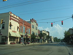
Hartford is a village in the township of the same name in Licking County, Ohio, United States. The population was 404 at the 2020 census.

<span class="mw-page-title-main">Grafton, Ohio</span> Village in Ohio, United States

Grafton is a village in Lorain County, Ohio, United States, along the East Branch of the Black River. The population was 5,895 at the 2020 census. The Lorain Correctional Institution and several other prisons are located in and near Grafton.

<span class="mw-page-title-main">Brunswick, Ohio</span> City in Ohio, United States

Brunswick is the largest city in Medina County, Ohio, United States, approximately 20 miles (32 km) southwest of Cleveland. The population was 35,426 at the 2020 census. It is part of the Cleveland metropolitan area.

<span class="mw-page-title-main">Brookville, Ohio</span> City in Ohio, United States

Brookville is a small city in northwestern Montgomery County, Ohio, United States. It is a suburb of Dayton. The population was 5,989 at the 2020 census.

<span class="mw-page-title-main">West Carrollton, Ohio</span> City in Ohio, United States

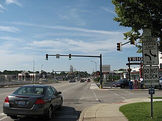
West Carrollton is a city in Montgomery County, Ohio, United States. A suburb of Dayton, its population was 13,129 at the 2020 census. It is part of the Dayton Metropolitan Statistical Area. The Great Miami River runs through the town and forms most of its northern border.

<span class="mw-page-title-main">Dexter City, Ohio</span> Village in Ohio, United States

Dexter City is a village in Noble County, Ohio, United States, along the West Fork of Duck Creek. The population was 81 at the 2020 census. Dexter City was laid out in 1870, and named after Dexter W. Sullivan, an early settler.

<span class="mw-page-title-main">Shawnee, Perry County, Ohio</span> Village in Ohio, United States

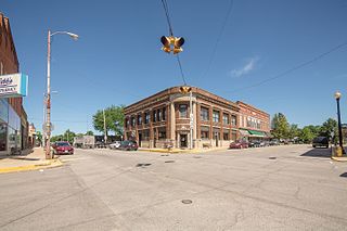
Shawnee is a village in Perry County, Ohio, United States. The population was 505 at the 2020 census. It is 9 miles (14 km) south of the county seat of New Lexington.

<span class="mw-page-title-main">Fairlawn, Ohio</span> City in Ohio, United States

Fairlawn is a city in western Summit County, Ohio, United States, and a suburb of Akron. The population was 7,710 at the 2020 census. It is part of the Akron metropolitan area.

<span class="mw-page-title-main">Richfield, Ohio</span> Village in Ohio, United States

Richfield is a village in Summit County, Ohio, United States. The population was 3,729 at the 2020 census. It is located midway between Akron and Cleveland and is part of the Akron metropolitan area.

<span class="mw-page-title-main">Marshallville, Ohio</span> Village in Ohio, United States

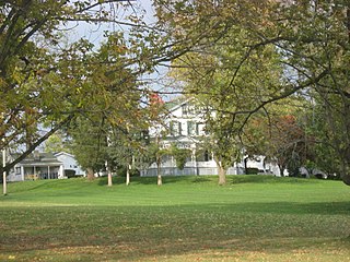
Marshallville is a village in Wayne County, Ohio. The population was 789 at the time of the 2020 census. Marshallville was originally called Bristol, and under the latter name was laid out in 1817.

<span class="mw-page-title-main">Monroe, Ohio</span> City in Ohio, United States

Monroe is a city in east central Butler and west central Warren counties in the southwestern part of the U.S. state of Ohio. The population was 15,412 at the 2020 census. Monroe is a part of the Cincinnati metropolitan area.

<span class="mw-page-title-main">Rittman, Ohio</span> City in Ohio, United States

Rittman is a city in Medina and Wayne counties in the U.S. state of Ohio. All but a small portion of the city is in Wayne County, within commuting distance of Akron, Canton and Cleveland. The population was 6,131 at the 2020 census.

<span class="mw-page-title-main">Mogadore, Ohio</span> Village in Ohio, United States

Mogadore is a village in Portage and Summit counties in the U.S. state of Ohio. The population was 3,811 at the 2020 census. A suburb of Akron, it is part of the Akron metropolitan area.

<span class="mw-page-title-main">Brimfield (CDP), Ohio</span> CDP in Ohio, United States

Brimfield is a census-designated place (CDP) in Portage County, Ohio, United States. As of the 2020 census, the CDP had a population of 3,365. It is located in the central part of Brimfield Township, a rural area between the Ohio cities of Akron and Kent with light industry, strip-malls, subdivisions, and farms.

References

  1. "ArcGIS REST Services Directory". United States Census Bureau. Retrieved September 20, 2022.
  2. 1 2 U.S. Geological Survey Geographic Names Information System: Orrville, Ohio
  3. 1 2 3 "U.S. Census website". United States Census Bureau . Retrieved January 31, 2008.
  4. Overman, William Daniel (1958). Ohio Town Names. Akron, OH: Atlantic Press. p. 105.
  5. "Post offices". Jim Forte Postal History. Retrieved June 18, 2016.
  6. "US Gazetteer files 2010". United States Census Bureau. Archived from the original on January 25, 2012. Retrieved January 6, 2013.
  7. "Population of Civil Divisions Less than Counties" (PDF). Statistics of the Population of the United States at the Ninth Census. U.S. Census Bureau. 1870. Retrieved May 17, 2020.
  8. "Population of Civil Divisions Less than Counties" (PDF). Statistics of the Population of the United States at the Tenth Census. U.S. Census Bureau. 1880. Retrieved November 28, 2013.
  9. "Population: Ohio" (PDF). 1910 U.S. Census. U.S. Census Bureau. Retrieved November 28, 2013.
  10. "Population: Ohio" (PDF). 1930 US Census. U.S. Census Bureau. Retrieved November 28, 2013.
  11. "Number of Inhabitants: Ohio" (PDF). 18th Census of the United States. U.S. Census Bureau. 1960. Retrieved May 17, 2020.
  12. "Ohio: Population and Housing Unit Counts" (PDF). U.S. Census Bureau. Retrieved November 22, 2013.
  13. "Orville city, Ohio". census.gov. Retrieved July 6, 2022.
  14. "U.S. Census website". United States Census Bureau . Retrieved January 6, 2013.
  15. "Smucker products have a new home at state-of-the-art facility in Orrville". Akron Beacon Journal. Retrieved May 22, 2019.