Otisville, Michigan

Last updated

Otisville, Michigan
Otisville, MI location.png
Location within Genesee County
USA Michigan location map.svg
Red pog.svg
Otisville
Location within the state of Michigan
Coordinates: 43°09′55″N83°31′27″W / 43.16528°N 83.52417°W / 43.16528; -83.52417
Country United States
State Michigan
County Genesee
Township Forest
Settled1836
Platted 1863
Incorporated1877
Government
  Type Village council
  PresidentJeffrey Lutze
  ClerkLisa Adolph
Area
[1]
  Total0.97 sq mi (2.52 km2)
  Land0.88 sq mi (2.28 km2)
  Water0.09 sq mi (0.24 km2)  9.28%
Elevation
814 ft (248 m)
Population
 (2020)
  Total819
  Density929.63/sq mi (358.97/km2)
Time zone UTC-5 (EST)
  Summer (DST) UTC-4 (EDT)
ZIP code(s)
48463
Area code 810
FIPS code 26-61600 [2]
GNIS feature ID0634154 [3]
Website www.otisvillemi.com

Otisville is a village in Forest Township, Genesee County in the U.S. state of Michigan. The population was 864 at the 2010 census. It is located along M-15, just south of M-57. It is part of the Flint metropolitan area.

Contents

History

The first land entry for the Forest (after the heavy growth of trees) community was made in March 1836 by James Seymour. The first settlers, Henry Heister and family, came in 1837. The township was organized in 1837, with the second settler, Nathaniel Smith, elected supervisor. [4] In 1851, a sawmill was built by John Hayes, who sold the mill to Francis Otis the next year. [4] On February 14, 1855, the post office opened with postmaster John Crawford. On April 5, 1861, the post office was renamed to Otisville. [4] The village was platted by William F. Otis and T.D. Crocker in 1863. In 1874, a station opened by the Pere Marquette Railway in the village. [4]

The Village of Otisville was incorporated in 1877. [4]

Geography

According to the United States Census Bureau, the village has a total area of 0.97 square miles (2.51 km2), of which 0.88 square miles (2.28 km2) is land and 0.09 square miles (0.23 km2) is water. [5]

Demographics

Historical population
CensusPop.Note
1880 349
1890 277−20.6%
1900 2915.1%
1910 3127.2%
1920 36416.7%
1930 45023.6%
1940 53418.7%
1950 59210.9%
1960 70118.4%
1970 7243.3%
1980 682−5.8%
1990 7246.2%
2000 88221.8%
2010 864−2.0%
2020 819−5.2%
U.S. Decennial Census [6]

2010 census

As of the census [7] of 2010, there were 864 people, 342 households, and 225 families living in the village. The population density was 981.8 inhabitants per square mile (379.1/km2). There were 379 housing units at an average density of 430.7 per square mile (166.3/km2). The racial makeup of the village was 97.8% White, 0.5% African American, 0.5% Native American, 0.1% Asian, 0.1% from other races, and 1.0% from two or more races. Hispanic or Latino of any race were 1.2% of the population.

There were 342 households, of which 36.3% had children under the age of 18 living with them, 46.2% were married couples living together, 13.5% had a female householder with no husband present, 6.1% had a male householder with no wife present, and 34.2% were non-families. 30.4% of all households were made up of individuals, and 10.8% had someone living alone who was 65 years of age or older. The average household size was 2.53 and the average family size was 3.09.

The median age in the village was 36.9 years. 27.3% of residents were under the age of 18; 7.7% were between the ages of 18 and 24; 24.5% were from 25 to 44; 27.4% were from 45 to 64, and 13.2% were 65 years of age or older. The gender makeup of the village was 49.7% male and 50.3% female.

2000 census

As of the census [2] of 2000, there were 882 people, 343 households, and 244 families living in the village. The population density was 999.1 inhabitants per square mile (385.8/km2). There were 369 housing units at an average density of 418.0 per square mile (161.4/km2). The racial makeup of the village was 96.15% White, 1.02% African American, 0.45% Native American, 0.11% Pacific Islander, 0.57% from other races, and 1.70% from two or more races. Hispanic or Latino of any race were 1.59% of the population.

There were 343 households, out of which 38.5% had children under the age of 18 living with them, 51.9% were married couples living together, 14.3% had a female householder with no husband present, and 28.6% were non-families. 23.9% of all households were made up of individuals, and 9.0% had someone living alone who was 65 years of age or older. The average household size was 2.57 and the average family size was 2.99.

In the village, the population was spread out, with 27.4% under the age of 18, 10.9% from 18 to 24, 32.3% from 25 to 44, 19.8% from 45 to 64, and 9.5% who were 65 years of age or older. The median age was 32 years. For every 100 females, there were 92.2 males. For every 100 females age 18 and over, there were 86.0 males.

The median income for a household in the village was $40,341, and the median income for a family was $45,769. Males had a median income of $44,167 versus $21,083 for females. The per capita income for the village was $17,540. About 3.4% of families and 6.0% of the population were below the poverty line, including 3.7% of those under age 18 and 12.9% of those age 65 or over.

Related Research Articles

<span class="mw-page-title-main">Grand Rivers, Kentucky</span> City in Kentucky, United States

Grand Rivers is a home rule-class city in Livingston County, Kentucky, in the United States. The population was 382 at the 2010 census, up from 343 in 2000. It is part of the Paducah, KY-IL Metropolitan Statistical Area.

<span class="mw-page-title-main">Attica Township, Michigan</span> Civil township in Michigan, United States

Attica Township is a civil township of Lapeer County in the U.S. state of Michigan. The population was 4,706 at the 2020 Census.

<span class="mw-page-title-main">Rothbury, Michigan</span> Village in Michigan, United States

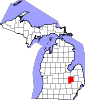
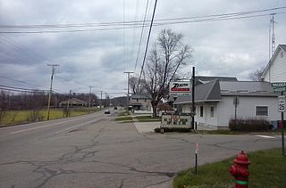
Rothbury is a village in Grant Township, Oceana County in the U.S. state of Michigan. The population was 486 at the 2010 census.

<span class="mw-page-title-main">Brooklyn Heights, Missouri</span> Village in Missouri, United States

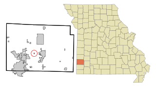
Brooklyn Heights is a village in Jasper County, Missouri, United States. The population was 101 at the 2020 census. It is part of the Joplin, Missouri Metropolitan Statistical Area.

<span class="mw-page-title-main">Bel-Ridge, Missouri</span> City in Missouri, United States

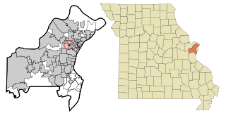
Bel-Ridge is a suburban city in northern St. Louis County, Missouri, United States. The population was 2,737 at the 2010 census. Bel-Ridge is part of the Normandy Schools Collaborative. Bel-Ridge became a city in 2015 by a vote of the voters.

<span class="mw-page-title-main">Sycamore Hills, Missouri</span> Village in Missouri, United States

Sycamore Hills is a village in St. Louis County, Missouri, United States. The population is 560 at the 2020 census.

<span class="mw-page-title-main">Chamisal, New Mexico</span> Census-designated place in Taos County, New Mexico, United States

Chamisal is a census-designated place (CDP) in Taos County, New Mexico. It is located along the scenic High Road to Taos. The population was 301 at the time of the 2000 census.

<span class="mw-page-title-main">Mineville-Witherbee, New York</span> Former CDP in New York, United States

Mineville-Witherbee was a census-designated place in the town of Moriah in Essex County, New York, United States. The population was 1,747 at the 2000 census. For the 2010 census, the area was split into two separate CDPs comprising the hamlets of Mineville and Witherbee. They are located in the northern part of Moriah, northwest of Port Henry. Mineville was named for the iron ore mines that used to operate here.

<span class="mw-page-title-main">Mount Hope, New York</span> Town in New York, United States

Mount Hope is a town in the northwestern part of Orange County, New York, United States, west of Middletown. The northern town line is the border of Sullivan County. The population was 6,537 at the 2020 census.

<span class="mw-page-title-main">Otisville, New York</span> Village in New York, United States

Otisville is a village in Orange County, New York, United States. The population was 969 at the 2020 census. It is part of the Poughkeepsie–Newburgh–Middletown, NY Metropolitan Statistical Area as well as the larger New York–Newark–Bridgeport, NY-NJ-CT-PA Combined Statistical Area.

<span class="mw-page-title-main">Dundee, New York</span> Village in New York, United States

Dundee is a village in Yates County, New York, United States. The population was 1,725 at the 2010 census. The name was taken from Dundee, the city in Scotland with a population of 148,260.

<span class="mw-page-title-main">Highland Hills, Ohio</span> Village in Ohio, United States

Highland Hills is a village in Cuyahoga County, Ohio, United States. The population was 662 at the 2020 census. A suburb of Cleveland, it was formally incorporated in 1990.

<span class="mw-page-title-main">Addyston, Ohio</span> Village in Ohio, United States

Addyston is a village in Miami Township, Hamilton County, Ohio, United States. Located along the Ohio River, it is a western suburb of the neighboring city of Cincinnati. The population was 927 at the 2020 census.

<span class="mw-page-title-main">Lowellville, Ohio</span> Village in Ohio, United States

Lowellville is a village in eastern Mahoning County, Ohio, United States, along the Mahoning River. The population was 996 at the 2020 census. Located about 8 miles (13 km) southeast of Youngstown, it is part of the Youngstown–Warren metropolitan area.

<span class="mw-page-title-main">Belmore, Ohio</span> Village in Ohio, United States

Belmore is a village in Putnam County, Ohio, United States. The population was 65 at the 2020 census.

<span class="mw-page-title-main">Clarksburg, Ohio</span> Village in Ohio, United States

Clarksburg is a village in Ross County, Ohio, United States. The population was 409 at the 2020 census.

<span class="mw-page-title-main">Parral, Ohio</span> Village in Ohio, United States

Parral is a village in Tuscarawas County, Ohio, United States. The population was 205 at the 2020 census.

<span class="mw-page-title-main">Roswell, Ohio</span> Village in Ohio, United States

Roswell is a village in Tuscarawas County, Ohio, United States. The population was 219 at the 2020 census.

<span class="mw-page-title-main">Bethlehem, West Virginia</span> Village in West Virginia, United States

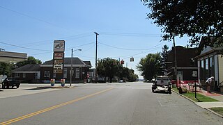
Bethlehem is a village in Ohio County, West Virginia, United States. It is part of the Wheeling, West Virginia Metropolitan Statistical Area. The population was 2,499 at the 2010 census.

<span class="mw-page-title-main">Monticello, Green County, Wisconsin</span> Village in Wisconsin, United States

Monticello is a village in Green County, Wisconsin, United States. The population was 1,217 as of the 2010 census.

References

  1. "2020 U.S. Gazetteer Files". United States Census Bureau. Retrieved May 21, 2022.
  2. 1 2 "U.S. Census website". United States Census Bureau . Retrieved January 31, 2008.
  3. "US Board on Geographic Names". United States Geological Survey. October 25, 2007. Retrieved January 31, 2008.
  4. 1 2 3 4 5 Romig, Walter (1973). Michigan Place Names. Walter Romig. p. 202.
  5. "US Gazetteer files 2010". United States Census Bureau. Archived from the original on January 25, 2012. Retrieved November 25, 2012.
  6. "Census of Population and Housing". Census.gov. Retrieved June 4, 2015.
  7. "U.S. Census website". United States Census Bureau . Retrieved November 25, 2012.

43°09′58″N83°31′28″W / 43.16611°N 83.52444°W / 43.16611; -83.52444