
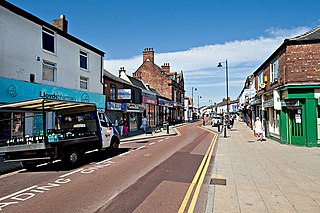
Aspatria is a town and civil parish in Cumberland, Cumbria, England. The town rests on the north side of the Ellen Valley, overlooking a panoramic view of the countryside, with Skiddaw to the South and the Solway Firth to the North. Its developments are aligned approximately east–west along the A596 Carlisle to Workington road and these extend to approximately 2 miles (3.2 km) in length. It lies about 8 miles (13 km) northeast of Maryport, a similar distance to the Southwest of Wigton, about 9 miles (14 km) north of Cockermouth and 5 miles (8.0 km) from the coast and Allonby. It comprises the townships of Aspatria and Brayton, Hayton and Mealo, and Oughterside and Allerby, the united area being 8,345 acres (3,377 ha); while the town takes up an area of 1,600 acres (647 ha). In earlier days a Roman road leading from "Old Carlisle" to Ellenborough passed through the hamlet.

Eastwood is a former coal mining town and civil parish in the Broxtowe district of Nottinghamshire, England, 8 miles (13 km) northwest of Nottingham. Mentioned in Domesday Book, it expanded rapidly during the Industrial Revolution. The Midland Railway was formed here and it is the birthplace of D. H. Lawrence.

Knurów is a city near Katowice in Silesia, southern Poland. Knurów is an outer city of the Metropolis GZM, a metropolis with a population of two million.

Allerdale was a non-metropolitan district of Cumbria, England, with borough status. Its council – Allerdale Borough Council – was based in Workington, and the borough had a population of 96,422 at the 2011 census.

Maryport is a town and civil parish in the Cumberland district, in the ceremonial county of Cumbria, England. In 2011 the parish had a population of 11,262.

Middleton is a largely residential suburb of Leeds in West Yorkshire, England and historically a village in the West Riding of Yorkshire. It is situated on a hill 4 miles (6 km) south of Leeds city centre and 165 miles (266 km) north north-west of London.

Grindon is a village and former civil parish, now in the parish of Grindon and Thorpe Thewles, in the Stockton-on-Tees district, in the ceremonial county of Durham, England. The civil parish population at the census 2001 was 2,603 reducing to 2,484 at the 2011 Census. In the 2021 census, the population of Grindon and Thorpe Thewles parish, now no longer including Wynyard, was 940. It is situated between Sedgefield and Stockton-on-Tees, near to Thorpe Thewles and Thorpe Larches.
Atherton is a town in the Metropolitan Borough of Wigan in Greater Manchester, England and historically part of Lancashire. The town, including Hindsford, Howe Bridge and Hag Fold, is 5 miles (8.0 km) south of Bolton, 7 miles (11.3 km) east of Wigan, and 10 miles (16.1 km) northwest of Manchester. From the 17th century, for about 300 years, Atherton was known as Chowbent, which was frequently shortened to Bent, the town's old nickname. During the Industrial Revolution, the town was a key part of the Manchester Coalfield.
Mellor is a village in the Stockport district, in Greater Manchester, England, lying between Marple Bridge and New Mills, Derbyshire.
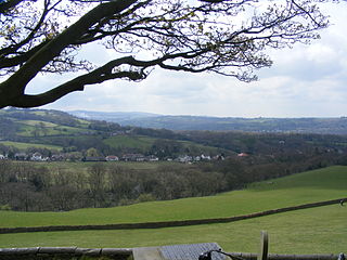
Bothel and Threapland is a civil parish in Cumbria, England, just outside the Lake District National Park. According to the 2001 census, it had a population of 438. The parish includes the villages of Bothel and Threapland. The village of Bothel is south-east of the parish of Aspatria and Threapland is south of Aspatria and Carlisle is eighteen miles (29 km) North-east of the parish. It had a population of 483 in the 2011 census figures.

Broughton Moor is a village and civil parish in Cumbria, England. It is situated on an extensive moor about 2 miles (3.2 km) north of Broughton, 5 miles (8.0 km) north west of Cockermouth, 2.5 miles (4.0 km) south of Maryport and 4.5 miles (7.2 km) north of Workington.

Fletchertown is a small village in the Cumberland district of Cumbria, England.

Dearham is a village and civil parish in Cumbria, historically part of Cumberland, near the Lake District National Park in England. It lies about 2 miles (3.2 km) east of Maryport and 5 miles (8.0 km) west of Cockermouth.

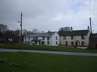
Harriston is a small hamlet in Cumbria, England, consisting of approximately 100 houses.
Norton le Moors is in the north-east of the city of Stoke-On-Trent, Staffordshire, England, mostly within the city boundary, with the rest in the Staffordshire Moorlands district.

Gilcrux is a small village and civil parish in the ceremonial county of Cumbria, England, and historically part of Cumberland. It is situated just outside the Lake District National Park.

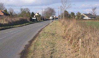
Hayton is a village in the Cumberland unitary authority area of Cumbria, England. It is the only settlement in the civil parish of Hayton and Mealo. Historically located in Cumberland, and on a minor road between the B5300 and the A596, it is approximately 2 miles from the coast. Nearby settlements include the town of Aspatria and the villages of Oughterside and Prospect. A small tributary called Patten Beck runs across the village, through the grounds of the castle.
Holme East Waver is a civil parish in Cumbria, United Kingdom. It is bordered to the north by the civil parish of Bowness-on-Solway, to the east by the civil parishes of Kirkbride, Woodside, and Waverton, and to the south by the civil parishes of Dundraw and Holme Abbey, lands common to Holme St. Cuthbert, Holme Low, and Holme Abbey, and the town of Silloth-on-Solway. At the 2001 census, it had a population of 306 in 121 households, increasing slightly at the 2011 Census to a population of 318 in 130 households. It is named for the River Waver, and the rivers Waver and Wampool enter the Solway Firth at the western end of the parish. Part of the Solway Coast Area of Outstanding Natural Beauty is within the parish of Holme East Waver. The largest village is Newton Arlosh.
Hayton and Mealo is a civil parish in the Cumberland district, Cumbria. The only settlement is Hayton, a village in the centre of the parish, which had a population of 237 in the 2011 census. In 1848, its population was 378.

Oughterside and Allerby is a civil parish in the Cumberland district, Cumbria, England. In the 2011 census it had a population of 619. The north western boundary of the parish is a short stretch of coast, then, working clockwise, the parish is bordered by Hayton and Mealo to the north, Aspatria to the north east, Plumbland to the south east, Gilcrux to the south and Crosscanonby to the south west. The A596 road from Aspatria to Maryport passes through the parish, and the B5300 road follows its coastline in the north west. The main settlements in the parish are Allerby in the west and Oughterside and Prospect, in the east.


