
Pago Pago is the capital of American Samoa. It is in Maoputasi County on Tutuila, the main island of American Samoa.

Apra Harbor, also called Port Apra, is a deep-water port on the western side of the United States territory of Guam. It is considered one of the best natural ports in the Pacific Ocean. The harbor is bounded by Cabras Island and the Glass Breakwater to the north and the Orote Peninsula in the south. Naval Base Guam and the Port of Guam are the two major users of the harbor. It is also a popular recreation area for boaters, surfers, scuba divers, and other recreationalists.

Yona is a village in the United States territory of Guam.
Tumon Bay is a bay in the United States territory of Guam, opening to the Philippine Sea. It is bounded to the north by Two Lovers Point and to the south by Ypao Point. The entirety of the bay falls within the Tumon Bay Marine Preserve, also known as the Tumon Bay Marine Preserve Area (MPA) and Tumon Preserve, one of five marine preserves on Guam. The Preserve measures 4.54 square kilometers and is roughly two miles long. The platform of the fringing reef that separates the open ocean from the lagoon is up to 1,450 feet (440 m) wide. and up to one mile from the shore. The bay is located off of the Tumon area, the tourist center of the island, in the village of Tamuning. The bay is extensively utilized for recreation and fishing.

Cocos Lagoon appears as a small incomplete coral atoll attached to the south-western coast of Guam near the area of the village of Malesso'. It stretches about 5.5 km (3.4 mi) east-west and 3.5 km (2.2 mi) north-south, covering an area of more than 10 km2 (3.9 sq mi).
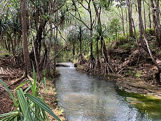
The Ylig River is one of the longest rivers in the United States territory of Guam. Rising close to the west coast some three kilometres north of Apra Heights, it traverses the island, flowing into the sea in the central east coast, south of the town of Yona. The course of this river roughly parallels that of the Pago River, which lies around five kilometres to the north. It runs about 6.83 miles in length, and has a watershed area of 16.08 square miles. The Ylig has two tributaries, the Tarzan and the Manengon rivers.

Agat Bay is a bay on the west coast of Guam. Its northern boundary is the Orote Peninsula, occupied entirely by Naval Base Guam, which itself lies within the village of Sånta Rita-Sumai. The bay stretches south along the coast of the village of Hågat to Facpi Point. With a length of some seven kilometers, the bay stretches for nearly one fifth of the west coast of Guam. The Asan Invasion Beach of the 1944 Battle of Guam is commemorated by the Agat Unit of War in the Pacific National Historical Park, which spans surface and subsurface areas from Apaca Point to Bangi Point. The NRHP-listed Agat World War II Amtrac is submerged off Agat Cemetery.

Alega is a village on the southeast coast of Tutuila Island, American Samoa. One of the island's least populous villages, it is located to the east of Pago Pago Harbor and to the west of Faga'itua Bay. Alega, with a population of 29 according to the 2020 U.S. Census, is one of the smallest villages in American Samoa, surpassing only Maloata and Sili in population.
ʻAuʻasi is a village in the east of Tutuila Island, American Samoa. One of the island's more populous villages, it is located on the south coast, close to the eastern tip of the island and to the smaller offshore island of Aunuʻu. It is located in Saʻole County.
The Lonfit River is a river in the United States territory of Guam. It empties into the Pago River. Contaminants from the Ordot Dump in Chalan Pago-Ordot, Guam, which was closed in 2011, leached into the river.

The Sigua River is a river in the United States territory of Guam. It empties into the Pago River.

Chalan Pago-Ordot is a village in the United States territory of Guam, containing the communities of Chalan Pago and Ordot. It is located in the eastern-central part of the island and is part of the Kattan (Eastern) District. The village's population has increased slightly since the island's 2010 census.
The Pago Bay Japanese pillboxes are a pair of World War II-era coastal defense pillboxes located on the shore of Pago Bay, located on the central east coast of Guam. Built out of steel-reinforced concrete mixed with coral stone, these two structures were built by Japanese defenders during their occupation of the island between 1941 and 1944. They were listed on the National Register of Historic Places in 1991 as Pagu' Pillbox I and Pagu' Pillbox II. Neither of these would have seen substantial action during the 1944 liberation of Guam, whose military activities were focused on the western, central, and northern parts of the island.

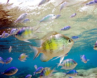
Recreational dive sites are specific places that recreational scuba divers go to enjoy the underwater environment or for training purposes. They include technical diving sites beyond the range generally accepted for recreational diving. In this context all diving done for recreational purposes is included. Professional diving tends to be done where the job is, and with the exception of diver training and leading groups of recreational divers, does not generally occur at specific sites chosen for their easy access, pleasant conditions or interesting features.

Blue Hole is a blue hole dive site off the western coast of Guam. It is variously described as "Guam’s signature natural feature dive," "the most requested dive site on Guam," and "one of Guam’s most popular divesites". It is located in northern Agat Bay, just south of the entrance to Apra Harbor. Despite being very close to the southern coast of the Orote Peninsula, sheer cliffs mean that it is done exclusively as a boat dive, typically out of Cabras Marina in Apra Harbor, located 20 minutes away. The top of the underwater sinkhole begins at about 60 ft (18 m) and drops to more than 300 ft (91 m). However, the sinkhole is located next to a wall and there is an opening that allows exit at about 130 ft (40 m), putting it just within the limits of an advanced recreational dive, depending on certifying agency. The opening of the sinkhole appears to be a heart shape to divers within it. While entry to the site is done while the dive boat is hooked into a mooring buoy, exit typically requires deploying a surface marker buoy in east-to-west current and pickup in the open ocean.

Underwater diving encompasses a variety of economically and culturally significant forms of diving on the U.S. island territory of Guam. Scuba diving tourism is a significant component of the island's tourist activity, in particular for visitors from Japan and South Korea. Recreational diving by Guam residents has a lesser but still substantial economic impact. Marine biologists have raised concerns about the effect of diving upon the health of some of Guam's reefs. Recreational dive sites on Guam include submerged shipwrecks, such as the double wrecks of SMS Cormoran and Tokai Maru, and natural features, such as Blue Hole.
Adelup Point is limestone promontory in Hagåtña, Guam that extends into the Philippine Sea and separates Asan Bay from Hagåtña Bay. It has been the site of the Ricardo J. Bordallo Governor's Complex since 1990. Adelup is therefore a metonym for the Office of the Governor of Guam.
Piti Bomb Holes Marine Preserve is a marine protected area comprising all of Piti Bay on the western coast of Guam, located off of the village of Piti in the Philippine Sea. The defining "bomb hole" features, named because they look like bomb craters in the reef flat, are actually natural percolation pits where fresh water filters into the shallow lagoon at a depth of 25 to 30 feet. The largest pit houses the commercial Fish Eye Marine Park tourist attraction, which includes a wooden pier to a underwater observatory and a Seawalker tour of the lagoon bottom. It is visited by more than 200,000 people annually. The Piti preserve is the most ecologically diverse of Guam's five marine preserves. The pit around Fish Eye is a popular snorkeling and recreational diving site.
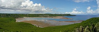
Pago Bay is the largest bay on the U.S. territory of Guam, located at the mouth of Pago River on the island's eastern coast. There is extensive evidence of CHamoru settlement before Spanish colonization during the late seventeenth century. During the Spanish-Chamorro Wars, the Spanish transferred the populations of Tinian and Aguigan to the village of Pago. However, a smallpox epidemic in 1856 killed much of the village's population and the Spanish moved survivors to other villages, leaving the bay shoreline largely uninhabited. The bay is popular with fishermen and recreationalists, and was the site of new housing development in the 2000s.

