
Guam is an organized, unincorporated territory of the United States in the Micronesia subregion of the western Pacific Ocean. Guam's capital is Hagåtña, and the most populous village is Dededo. It is the westernmost point and territory of the United States, reckoned from the geographic center of the U.S. In Oceania, Guam is the largest and southernmost of the Mariana Islands and the largest island in Micronesia. As of 2022, its population was 168,801. Chamorros are its largest ethnic group, but a minority on the multiethnic island. The territory spans 210 square miles and has a population density of 775 per square mile (299/km2).

Kingman Reef is a largely submerged, uninhabited, triangle-shaped reef, geologically an atoll, 9.0 nmi (20 km) east-west and 4.5 nmi (8 km) north-south, in the North Pacific Ocean, roughly halfway between the Hawaiian Islands and American Samoa. It has an area of 3 hectares and is a unincorporated territory of the United States in Oceania. The reef is administered by the United States Fish and Wildlife Service as the Kingman Reef National Wildlife Refuge. It was claimed by the US in 1859 and later used briefly as a stopover for commercial Pacific flying boat routes in the 1930s going to New Zealand; however, the route was changed with a different stopover. It was administered by the Navy from 1934 to 2000 and thereafter by the Fish and Wildlife Service. It has since become a marine protected area. In the 19th century, it was noted as a maritime hazard, earning the name Hazard Rocks, and is known to have been hit once in 1876. In the 21st century, it has been noted for its marine biodiversity and remote nature. Hundreds of fish and coral species are on and around the reef.

Pago Pago is the capital of American Samoa. It is in Maoputasi County on Tutuila, the main island of American Samoa.

Apra Harbor, also called Port Apra, is a deep-water port on the western side of the United States territory of Guam. It is considered one of the best natural ports in the Pacific Ocean. The harbor is bounded by Cabras Island and the Glass Breakwater to the north and the Orote Peninsula in the south. Naval Base Guam and the Port of Guam are the two major users of the harbor. It is also a popular recreation area for boaters, surfers, scuba divers, and other recreationalists.

Yona is a village in the United States territory of Guam.
Tumon Bay is a bay in the United States territory of Guam, opening to the Philippine Sea. It is bounded to the north by Two Lovers Point and to the south by Ypao Point. The entirety of the bay falls within the Tumon Bay Marine Preserve, also known as the Tumon Bay Marine Preserve Area (MPA) and Tumon Preserve, one of five marine preserves on Guam. The Preserve measures 4.54 square kilometers and is roughly two miles long. The platform of the fringing reef that separates the open ocean from the lagoon is up to 1,450 feet (440 m) wide. and up to one mile from the shore. The bay is located off of the Tumon area, the tourist center of the island, in the village of Tamuning. The bay is extensively utilized for recreation and fishing.

Cocos Lagoon appears as a small incomplete coral atoll attached to the south-western coast of Guam near the area of the village of Malesso'. It stretches about 5.5 km (3.4 mi) east-west and 3.5 km (2.2 mi) north-south, covering an area of more than 10 km2 (3.9 sq mi).
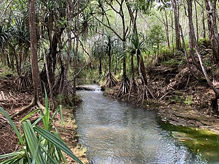
The Pago River is one of the longest rivers in the United States territory of Guam. It is fed by two inland rivers, Lonfit River and Sigua River. Rising close to the west coast, it traverses the island, flowing into the sea at Pago Bay in the central east coast. The village of Yona lies just to the south of the river's mouth.
The Ylig River is one of the longest rivers in the United States territory of Guam. Rising close to the west coast some three kilometres north of Apra Heights, it traverses the island, flowing into the sea in the central east coast, south of the town of Yona. The course of this river roughly parallels that of the Pago River, which lies around five kilometres to the north. It runs about 6.83 miles in length, and has a watershed area of 16.08 square miles. The Ylig has two tributaries, the Tarzan and the Manengon rivers.
The Lonfit River is a river in the United States territory of Guam. It empties into the Pago River. Contaminants from the Ordot Dump in Chalan Pago-Ordot, Guam, which was closed in 2011, leached into the river.

Chalan Pago-Ordot is a village in the United States territory of Guam, containing the communities of Chalan Pago and Ordot. It is located in the eastern-central part of the island and is part of the Kattan (Eastern) District. The village's population has increased slightly since the island's 2010 census.
Climate change in Guam encompasses the effects of climate change, attributed to man-made increases in atmospheric carbon dioxide, in the U.S. territory of Guam.
Majes-Siguas is an irrigation project in Peru which envisages transferring water from the Colca River to the Siguas River for irrigation purposes, and further to take water from the Apurimac River.

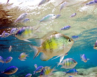
Underwater diving encompasses a variety of economically and culturally significant forms of diving on the U.S. island territory of Guam. Scuba diving tourism is a significant component of the island's tourist activity, in particular for visitors from Japan and South Korea. Recreational diving by Guam residents has a lesser but still substantial economic impact. Marine biologists have raised concerns about the effect of diving upon the health of some of Guam's reefs. Recreational dive sites on Guam include submerged shipwrecks, such as the double wrecks of SMS Cormoran and Tokai Maru, and natural features, such as Blue Hole.
Piti Bomb Holes Marine Preserve is a marine protected area comprising all of Piti Bay on the western coast of Guam, located off of the village of Piti in the Philippine Sea. The defining "bomb hole" features, named because they look like bomb craters in the reef flat, are actually natural percolation pits where fresh water filters into the shallow lagoon at a depth of 25 to 30 feet. The largest pit houses the commercial Fish Eye Marine Park tourist attraction, which includes a wooden pier to a underwater observatory and a Seawalker tour of the lagoon bottom. It is visited by more than 200,000 people annually. The Piti preserve is the most ecologically diverse of Guam's five marine preserves. The pit around Fish Eye is a popular snorkeling and recreational diving site.
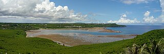
Pago Bay is the largest bay on the U.S. territory of Guam, located at the mouth of Pago River on the island's eastern coast. There is extensive evidence of CHamoru settlement before Spanish colonization during the late seventeenth century. During the Spanish-Chamorro Wars, the Spanish transferred the populations of Tinian and Aguigan to the village of Pago. However, a smallpox epidemic in 1856 killed much of the village's population and the Spanish moved survivors to other villages, leaving the bay shoreline largely uninhabited. The bay is popular with fishermen and recreationalists, and was the site of new housing development in the 2000s.
An epidemic of smallpox in 1856 on the west Pacific island of Guam, then under the control of Spain, resulted in the death of over half of the population, or about 4,500 people. The population collapse led Spanish authorities to transfer the population of Pago to Hagåtña, ending a settlement dating back before colonization. It also led the Governor of the Spanish Mariana Islands to encourage immigration to Guam.

