
São Vicente is one of the Barlavento Islands, the northern group within the Cape Verde archipelago in the Atlantic Ocean, off the West African coast. It is located between the islands of Santo Antão and Santa Luzia, with the Canal de São Vicente separating it from Santo Antão.
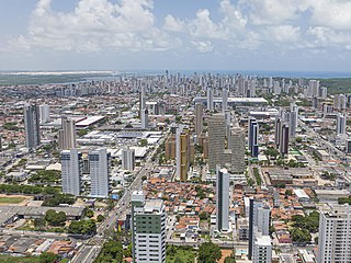
Natal is the capital and largest city of the state of Rio Grande do Norte, located in northeastern Brazil. According to IBGE's 2022 estimate, the city had a total population of 751,300, making it the 24th largest city in the country. Natal is a major tourist destination and an exporting hub of crustaceans, carnauba wax and fruits, mostly melon, sugar apple, cashew and papaya. Natal is Brazil's closest city to Africa and Europe, its Greater Natal International Airport connects the city with many Brazilian destinations and also operates some international flights. The city was one of the host cities of the 2014 FIFA World Cup.
Jinotega is the capital city of the Department of Jinotega in north-central Nicaragua.

Matagalpa is a department in central Nicaragua. It covers an area of 6,804 km2 and has a population of 600,057. The capital is the city of Matagalpa with a population of about 111,000.

Maia is a municipality in the Porto Metropolitan Area, Grande Porto subregion, in Norte Region, Portugal. It is located 11 km north of central Porto. The population in 2011 was 135,306, in an area of 82.99 km2 (32.04 sq mi). There is one city and three towns in the municipality.

Monte Cristi is a province in the northwest of the Dominican Republic. The capital city is San Fernando de Monte Cristi. The spelling Montecristi is also seen. The Montecristi province is located in the Cibao frontier region, on the north coast of the country and borders the nation of Haiti. The land area of the Montecristi province is 1,924.35 km2. It is divided into six municipalities and four municipal districts.

Estelí, officially Villa de San Antonio de Pavia de Estelí is a city and municipality within the Estelí department. It is the 8th largest city in Nicaragua due to the high urbanization of its municipality, at 84.8%, with an urban population of 111,244. It is also the 8th largest municipality, and an active commercial center in the north, known as "the Diamond of the Segovia" and the de facto capital of the north.

Velas is a municipality in the São Jorge Island, in the Portuguese autonomous region of Azores. The municipality encompasses the western portion of the island, with its municipal seat in the town of Velas on the south coast, and is divided into six parishes. The population in 2011 was 5,398, in an area of 117.38 km².

Marinha Grande is a municipality in the Leiria District, Portugal. The population in 2021 was 39,032, in an area of 187.25 km². The city itself has a population of 32,330.

Matagalpa is a city in Nicaragua which is the capital of the department of Matagalpa. The city has a population of 112,697, while the population of the department is 606,643. Matagalpa is Nicaragua's seventh largest city, the largest in the country's interior, and one of the most commercially active outside of Managua. Matagalpa is known as the "Pearl of the North" and "Land of Eternal Spring."
La Libertad is a municipality in the Chontales Department of Nicaragua. It is the birthplace of President Daniel Ortega, Cardinal Miguel Obando y Bravo, and Vice President Omar Halleslevens. It has a population of 14,712 people.
Tuma-La Dalia is a municipality in the Matagalpa Department of Nicaragua. The municipal seat is the town of La Dalia. The municipality takes its name from its two main towns: El Tuma and La Dalia. It is located 175 kilometers from the capital, Managua, and 45 kilometers from the city of Matagalpa, the departmental capital of the same name.
Desembocadura de Río Grande is a municipality of the South Caribbean Coast Autonomous Region in the Republic of Nicaragua. The head town is the locality of Karawala.
El Ayote is a municipality in the South Caribbean Coast Autonomous Region of Nicaragua. The population is 5,406.
El Tortuguero is a municipality in the South Caribbean Coast Autonomous Region of Nicaragua. It is located at about 530 km from Managua and can only be reached by an hour-long truck ride from El Rama.
La Cruz de Río Grande is a municipality in the South Caribbean Coast Autonomous Region of Nicaragua. According to the 2005 census, the population of La Cruz de Rio Grande was 3,000. It gets its name from the Rio Grande de Matagalpa which flows through it.
Muelle de los Bueyes is a town and a municipality in the South Caribbean Coast Autonomous Region of Nicaragua.

Pedrógão Grande is a municipality in the district of Leiria in Portugal. The population in 2011 was 3,915 in an area of 128.75 km2 (49.71 sq mi).
The following is an alphabetical list of topics related to Nicaragua.

