Cape May Court House is an unincorporated community and census-designated place (CDP) located within Middle Township in Cape May County, in the U.S. state of New Jersey. It is part of the Ocean City metropolitan statistical area. As of the 2020 United States census, the CDP’s population was 5,573, reflecting a 4.4% increase from the 5,338 enumerated at the 2010 U.S. census, in turn an increase of 13.5% from the 4,704 counted in the 2000 census. It is the county seat of Cape May County and serves as the principal administrative hub for the township. It constitutes part of the greater Philadelphia metropolitan area, or the Delaware Valley.

Dennis Township is a township in Cape May County, in the U.S. state of New Jersey. The township, and all of Cape May County, is part of the South Jersey region of the state and of the Ocean City metropolitan statistical area, and is part of the Philadelphia-Wilmington-Camden, PA-NJ-DE-MD combined statistical area, also known as the Delaware Valley or Philadelphia metropolitan area. As of the 2020 United States census, the township's population was 6,285, a decrease of 182 (−2.8%) from the 2010 census count of 6,467, which in turn reflected a decline of 25 (−0.4%) from the 6,492 counted in the 2000 census.

Erma is an unincorporated community and census-designated place (CDP) located within Lower Township in Cape May County, in the U.S. state of New Jersey. As of the 2020 United States census, the CDP's population was 2,031, a decline of 103 from the 2010 census count of 2,134.

Middle Township is a township in Cape May County, in the U.S. state of New Jersey. The township, and all of Cape May County, is part of the Ocean City metropolitan statistical area, and is part of the Philadelphia-Wilmington-Camden, PA-NJ-DE-MD combined statistical area, also known as the Delaware Valley or Philadelphia metropolitan area. As of the 2020 United States census, the township's population was 20,380, an increase of 1,469 (+7.8%) from the 2010 census count of 18,911, which in turn reflected an increase of 2,506 (+15.3%) from the 16,405 counted in the 2000 census. The township's Cape May Court House section is the county seat of Cape May County.

North Cape May is an unincorporated community and census-designated place (CDP) located within Lower Township in Cape May County, in the U.S. state of New Jersey. It is part of the Ocean City Metropolitan Statistical Area. At the 2010 United States Census, the CDP's population was 3,226. The Cape May–Lewes Ferry departs from the area. North Cape May is mostly a residential community, with no hotels but many vacation homes. Many people retire to the community.

Rio Grande is an unincorporated community and census-designated place (CDP) located within Middle Township and Lower Township in Cape May County, in the U.S. state of New Jersey.
Strathmere is an unincorporated community and census-designated place (CDP) located within Upper Township in Cape May County, in the U.S. state of New Jersey. As of the 2020 United States census, the CDP's population was 137, a decrease of 21 (−13.3%) from the 158 counted at the 2010 U.S. census, which reflected a decrease of 17 (−9.7%) from the 175 enumerated at the 2000 census.

Upper Township is a large township in Cape May County, in the U.S. state of New Jersey. The township, and all of Cape May County, is part of the South Jersey region of the state and of the Ocean City metropolitan statistical area, which is part of the Philadelphia-Wilmington-Camden, PA-NJ-DE-MD combined statistical area, also known as the Delaware Valley or Philadelphia metropolitan area. As of the 2020 United States census, the township's population was 12,539, an increase of 166 (+1.3%) from the 2010 census count of 12,373, which in turn reflected an increase of 258 (+2.1%) from the 12,115 counted in the 2000 census.

Forked River is an unincorporated community and census-designated place (CDP) located within Lacey Township, in Ocean County, in the U.S. state of New Jersey. As of the 2020 United States census, the CDP's population was 5,274, an increase of 30 (+0.6%) from the 5,244 enumerated at the 2010 census, which in turn reflected an increase of 330 (+6.7%) from the 4.914 counted in the 2000 census.

Ocean Acres is an unincorporated community and census-designated place (CDP) split between Barnegat Township and Stafford Township, in Ocean County, in the U.S. state of New Jersey. As of the 2010 United States Census, the CDP's population was 16,142, of which 925 were in Barnegat Township and 15,217 were in Stafford Township. Ocean Acres is located in the northwestern end of Stafford Township and part of Barnegat Township, and is the newest and biggest part of both communities, with approximately 5,500 lots in an area of 6 square miles (16 km2).
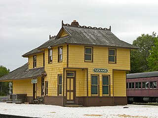
Tuckahoe is a census-designated place (CDP) unincorporated community located within Upper Township in Cape May County of New Jersey.
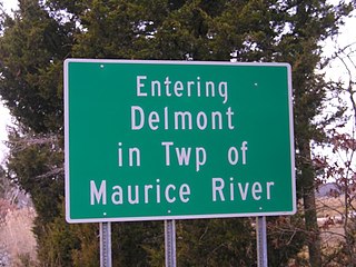
Delmont is an unincorporated community and census-designated place (CDP) located within Maurice River Township, in Cumberland County, in the U.S. state of New Jersey. The area is served as United States Postal Service ZIP Code 08314. It was first listed as a CDP in the 2020 census with a population of 122.

Marmora is an unincorporated community and census-designated place (CDP) in Upper Township, in Cape May County, in the U.S. state of New Jersey. It is part of the Ocean City Metropolitan Statistical Area. Its postal ZIP Code is 08223. Its 1990 population was approximately 4,420 persons.
Richland is an unincorporated community and census-designated place (CDP) located within Buena Vista Township in Atlantic County, in the U.S. state of New Jersey. The area is served as United States Postal Service ZIP Code 08350.

Dennisville is an unincorporated community and census-designated place (CDP) located within Dennis Township, in Cape May County, in the U.S. state of New Jersey. It is part of the Ocean City Metropolitan Statistical Area. Its postal ZIP Code is 08214.

Ocean View is an unincorporated community and census-designated place (CDP) located within Dennis Township in Cape May County, in the U.S. state of New Jersey. The area is served as United States Postal Service ZIP Code 08230. The post office was established in 1872, with William Doolittle as the first postmaster.

Beesley's Point is an unincorporated community and census-designated place (CDP) in Upper Township, in Cape May County, in the U.S. state of New Jersey. Beesley's Point is on Peck Bay across from Ocean City. Beesley's Point is home to the Beesley's Point Generating Station and one end of the now-closed Beesley's Point Bridge.

Burleigh is an unincorporated community and census-designated place (CDP) located within Middle Township in Cape May County, in the U.S. state of New Jersey; Until the 2000 census the area had been part of the Whitesboro-Burleigh CDP, which was split in 2010 into separate CDPs for Burleigh and Whitesboro. As of the 2010 United States Census, the CDP's population was 725.

Seaville is an unincorporated community and census-designated place (CDP) located within Upper Township in Cape May County, in the U.S. state of New Jersey.
Marshallville is an unincorporated community and census-designated place (CDP) located in Upper Township, Cape May County, in the U.S. state of New Jersey. It is on the northern edge of the county, bordered to the north, across the Tuckahoe River, by Corbin City in Atlantic County. It is bordered to the east by the unincorporated community of Tuckahoe.