North Cape May, New Jersey

Last updated

North Cape May, New Jersey
US Post Office N Cape May NJ.jpg
North Cape May Post Office
Cape May County New Jersey Incorporated and Unincorporated areas North Cape May Highlighted.svg
Location of North Cape May in Cape May County highlighted in red (left). Inset map: Location of Cape May County in New Jersey highlighted in orange (right).
Location map of Cape May County, New Jersey.svg
Red pog.svg
North Cape May
Location in Cape May County
USA New Jersey relief location map.svg
Red pog.svg
North Cape May
Location in New Jersey
Usa edcp relief location map.png
Red pog.svg
North Cape May
Location in the United States
Coordinates: 38°58′35″N74°57′05″W / 38.976427°N 74.951503°W / 38.976427; -74.951503
Country Flag of the United States.svg  United States
State Flag of New Jersey.svg  New Jersey
County Cape May
Township Lower
Area
[1]
  Total2.14 sq mi (5.53 km2)
  Land2.00 sq mi (5.19 km2)
  Water0.13 sq mi (0.33 km2)  2.49%
Elevation
[2]
13 ft (4 m)
Population
 (2020) [3]
  Total4,007
  Density1,997.51/sq mi (771.34/km2)
Time zone UTC−05:00 (Eastern (EST))
  Summer (DST) UTC−04:00 (Eastern (EDT))
ZIP Code
08204 - Cape May [4]
Area code 609
FIPS code 34-52650 [5] [6] [7]
GNIS feature ID02389569 [5] [8]

North Cape May is an unincorporated community and census-designated place (CDP) [9] located within Lower Township in Cape May County, in the U.S. state of New Jersey. [10] It is part of the Ocean City Metropolitan Statistical Area. At the 2010 United States Census, the CDP's population was 3,226. [11] [12] The Cape May–Lewes Ferry departs from the area. North Cape May is mostly a residential community, with no hotels but many vacation homes. Many people retire to the community.

Contents

North Cape May had existed as an independent borough, formed by an act of the New Jersey Legislature on March 19, 1928, from portions of Lower Township. The borough remained independent until April 30, 1945, when it was returned to Lower Township. [13] The borough had a population of 5 at the 1930 Census, [14] which increased to 8 by 1940. [15]

Geography

According to the United States Census Bureau, the CDP had a total area of 1.494 square miles (3.870 km2), including 1.457 square miles (3.773 km2) of land and 0.037 square miles (0.096 km2) of water (2.49%). [5] [16]

Demographics

Historical population
CensusPop.Note
1970 3,812
1980 4,0295.7%
1990 3,574−11.3%
2000 3,6181.2%
2010 3,226−10.8%
2020 4,00724.2%
Population sources:
1970-1980 [17] 2000 [18]
2010 [11] 2020 [3]

2010 census

The 2010 United States census counted 3,226 people, 1,395 households, and 896 families in the CDP. The population density was 2,214.3 per square mile (854.9/km2). There were 2,100 housing units at an average density of 1,441.5 per square mile (556.6/km2). The racial makeup was 92.87% (2,996) White, 3.22% (104) Black or African American, 0.34% (11) Native American, 0.59% (19) Asian, 0.00% (0) Pacific Islander, 1.30% (42) from other races, and 1.67% (54) from two or more races. Hispanic or Latino of any race were 3.66% (118) of the population. [11]

Of the 1,395 households, 20.7% had children under the age of 18; 47.2% were married couples living together; 13.3% had a female householder with no husband present and 35.8% were non-families. Of all households, 29.6% were made up of individuals and 15.2% had someone living alone who was 65 years of age or older. The average household size was 2.30 and the average family size was 2.82. [11]

18.2% of the population were under the age of 18, 7.7% from 18 to 24, 19.9% from 25 to 44, 31.8% from 45 to 64, and 22.3% who were 65 years of age or older. The median age was 47.6 years. For every 100 females, the population had 88.2 males. For every 100 females ages 18 and older there were 86.6 males. [11]

2000 census

As of the 2000 United States Census [6] there were 3,618 people, 1,544 households, and 1,008 families residing in the CDP. The population density was 997.8/km2 (2,583.4/mi2). There were 2,090 housing units at an average density of 576.4/km2 (1,492.3/mi2). The racial makeup of the CDP was 94.42% White, 2.79% African American, 0.44% Native American, 0.47% Asian, 0.75% from other races, and 1.13% from two or more races. Hispanic or Latino of any race were 2.16% of the population. [18]

There were 1,544 households, out of which 27.0% had children under the age of 18 living with them, 48.1% were married couples living together, 13.7% had a female householder with no husband present, and 34.7% were non-families. 29.6% of all households were made up of individuals, and 15.5% had someone living alone who was 65 years of age or older. The average household size was 2.33 and the average family size was 2.88. [18]

In the CDP the population was spread out, with 22.8% under the age of 18, 6.0% from 18 to 24, 26.3% from 25 to 44, 24.2% from 45 to 64, and 20.7% who were 65 years of age or older. The median age was 42 years. For every 100 females, there were 86.7 males. For every 100 females age 18 and over, there were 81.3 males. [18]

The median income for a household in the CDP was $37,071, and the median income for a family was $42,161. Males had a median income of $33,036 versus $26,875 for females. The per capita income for the CDP was $18,420. About 1.0% of families and 4.1% of the population were below the poverty line, including 3.1% of those under age 18 and 3.0% of those age 65 or over. [18]

Wineries

Parks and recreation

North Cape May is the site of the Lower Township municipal pool. [19]

Education

As with other parts of Lower Township, it is served by Lower Township School District for primary grades and Lower Cape May Regional School District for secondary grades. David C. Douglass Memorial Elementary School (Pre-Kindergarten and Kindergarten) is in Villas CDP. The other three elementary schools are in Cold Spring: Carl T. Mitnick (grades 1-2), Maud Abrams (grades 3-4), and Sandman Consolidated (grades 5-6). The LCMR schools (Richard Teitelman Middle and Lower Cape May Regional High School) are in the Erma area.

Students are also eligible to attend Cape May County Technical High School in Cape May Court House, which serves students from the entire county in its comprehensive and vocational programs, which are offered without charge to students who are county residents. [20] [21] Special needs students may be referred to Cape May County Special Services School District in Cape May Court House.

South Cape Christian Academy, a private Christian school, opened sometime after 1976, [22] and was located in a campus with a North Cape May postal address; as of 2010 it was outside of the North Cape May CDP. [23] Circa 1990 it merged into Cape Christian Academy, [22] which is now in a consolidated campus in Middle Township, with a Cape May Court House postal address and located in the CMCH CDP. [24] Richard Degener of the Press of Atlantic City described the consolidated campus as being in Burleigh. [22]

The nearest private Catholic school serving North Cape May is Wildwood Catholic Academy (PreK-12) in North Wildwood, which the Roman Catholic Diocese of Camden has under its supervision. Previously the area Catholic school was Our Lady Star of the Sea School in Cape May, which served as the parish school for St. John of God Church in North Cape May. [25] In 2010 Our Lady Star of the Sea merged into Cape Trinity Regional School (PreK – 8) in North Wildwood. [26] That school in turn merged into Wildwood Catholic Academy in 2020. [27]

Notable people

People who were born in, residents of, or otherwise closely associated with North Cape May include:

Related Research Articles

<span class="mw-page-title-main">Cape May Court House, New Jersey</span> Populated place in Cape May County, New Jersey, US

Cape May Court House is an unincorporated community and census-designated place (CDP) located within Middle Township in Cape May County, in the U.S. state of New Jersey. It is part of the Ocean City metropolitan statistical area. As of the 2020 United States census, the CDP's population was 5,573, reflecting a 4.4% increase from the 5,338 enumerated at the 2010 U.S. census, in turn an increase of 13.5% from the 4,704 counted in the 2000 census. It is the county seat of Cape May County and serves as the principal administrative hub for the township. It constitutes part of the greater Philadelphia metropolitan area, or the Delaware Valley.

<span class="mw-page-title-main">Dennis Township, New Jersey</span> Township in Cape May County, New Jersey, US

Dennis Township is a township in Cape May County, in the U.S. state of New Jersey. The township, and all of Cape May County, is part of the South Jersey region of the state and of the Ocean City metropolitan statistical area, and is part of the Philadelphia-Wilmington-Camden, PA-NJ-DE-MD combined statistical area, also known as the Delaware Valley or Philadelphia metropolitan area. As of the 2020 United States census, the township's population was 6,285, a decrease of 182 (−2.8%) from the 2010 census count of 6,467, which in turn reflected a decline of 25 (−0.4%) from the 6,492 counted in the 2000 census.

<span class="mw-page-title-main">Diamond Beach, New Jersey</span> Populated place in Cape May County, New Jersey, US

Diamond Beach is an unincorporated community and census-designated place (CDP) located within Lower Township in Cape May County, in the U.S. state of New Jersey. The CDP, and all of Cape May County, is part of the Ocean City metropolitan statistical area, and is part of the Philadelphia-Wilmington-Camden, PA-NJ-DE-MD combined statistical area, also known as the Delaware Valley or Philadelphia metropolitan area. As of the United States 2020 Census, the CDP's population was 203, an increase of 67 from the 2010 census count of 136.

<span class="mw-page-title-main">Erma, New Jersey</span> Populated place in Cape May County, New Jersey, US

Erma is an unincorporated community and census-designated place (CDP) located within Lower Township in Cape May County, in the U.S. state of New Jersey. As of the 2020 United States census, the CDP's population was 2,031, a decline of 103 from the 2010 census count of 2,134.

<span class="mw-page-title-main">Lower Township, New Jersey</span> Township in Cape May County, New Jersey, US

Lower Township is a township in Cape May County, in the U.S. state of New Jersey. The township, and all of Cape May County, is part of the Ocean City metropolitan statistical area, and is part of the Philadelphia-Wilmington-Camden, PA-NJ-DE-MD combined statistical area, also known as the Delaware Valley or Philadelphia metropolitan area. As of the 2020 United States census, the township's population was 22,057, a decrease of 809 (−3.5%) from the 2010 census count of 22,866, which in turn reflected a decrease of 79 (−0.3%) from the 22,945 counted in the 2000 census.

<span class="mw-page-title-main">Middle Township, New Jersey</span> Township in Cape May County, New Jersey, US

Middle Township is a township in Cape May County, in the U.S. state of New Jersey. The township, and all of Cape May County, is part of the Ocean City metropolitan statistical area, and is part of the Philadelphia-Wilmington-Camden, PA-NJ-DE-MD combined statistical area, also known as the Delaware Valley or Philadelphia metropolitan area. As of the 2020 United States census, the township's population was 20,380, an increase of 1,469 (+7.8%) from the 2010 census count of 18,911, which in turn reflected an increase of 2,506 (+15.3%) from the 16,405 counted in the 2000 census. The township's Cape May Court House section is the county seat of Cape May County.

<span class="mw-page-title-main">North Wildwood, New Jersey</span> City in Cape May County, New Jersey, US

North Wildwood is a city located on the Jersey Shore in Cape May County, in the U.S. state of New Jersey. The city, and all of Cape May County, is part of the Ocean City metropolitan statistical area, and is part of the Philadelphia-Wilmington-Camden, PA-NJ-DE-MD combined statistical area, also known as the Delaware Valley or Philadelphia metropolitan area. As of the 2020 United States census, the city's population was 3,621, a decrease of 420 (−10.4%) from the 2010 census count of 4,041, which in turn reflected a decline of 894 (−18.1%) from the 4,935 counted in the 2000 census. North Wildwood is home to the Hereford Inlet Lighthouse.

<span class="mw-page-title-main">Rio Grande, New Jersey</span> Place in Cape May County, New Jersey, United States

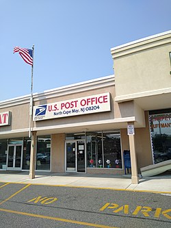
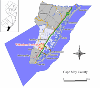
Rio Grande is an unincorporated community and census-designated place (CDP) located within Middle Township and Lower Township in Cape May County, in the U.S. state of New Jersey.

<span class="mw-page-title-main">Strathmere, New Jersey</span> Populated place in Cape May County, New Jersey, US

Strathmere is an unincorporated community and census-designated place (CDP) located within Upper Township in Cape May County, in the U.S. state of New Jersey. As of the 2020 United States census, the CDP's population was 137, a decrease of 21 (−13.3%) from the 158 counted at the 2010 U.S. census, which reflected a decrease of 17 (−9.7%) from the 175 enumerated at the 2000 census.

<span class="mw-page-title-main">Upper Township, New Jersey</span> Township in Cape May County, New Jersey, US

Upper Township is a large township in Cape May County, in the U.S. state of New Jersey. The township, and all of Cape May County, is part of the South Jersey region of the state and of the Ocean City metropolitan statistical area, which is part of the Philadelphia-Wilmington-Camden, PA-NJ-DE-MD combined statistical area, also known as the Delaware Valley or Philadelphia metropolitan area. As of the 2020 United States census, the township's population was 12,539, an increase of 166 (+1.3%) from the 2010 census count of 12,373, which in turn reflected an increase of 258 (+2.1%) from the 12,115 counted in the 2000 census.

<span class="mw-page-title-main">Villas, New Jersey</span> Place in Cape May County, New Jersey, United States

Villas, also known as the Villas, is an unincorporated community and census-designated place (CDP) located within Lower Township, in Cape May County, in the U.S. state of New Jersey. The locality is also home to the community of Miami Beach. At the 2010 census, the CDP's population was 9,483.

<span class="mw-page-title-main">West Wildwood, New Jersey</span> Borough in Cape May County, New Jersey, United States

West Wildwood is a borough in Cape May County, in the U.S. state of New Jersey. The city, and all of Cape May County, is part of the Ocean City metropolitan statistical area, and is part of the Philadelphia-Wilmington-Camden, PA-NJ-DE-MD combined statistical area, also known as the Delaware Valley or Philadelphia metropolitan area. As of the 2020 United States census, the borough's population was 540, a decrease of 63 (−10.4%) from the 2010 census count of 603, which in turn reflected an increase of 155 (+34.6%) from the 448 counted in the 2000 census. The summer population grows to as much as 5,000.

<span class="mw-page-title-main">Whitesboro-Burleigh, New Jersey</span> Populated place in Cape May County, New Jersey, US

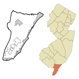
Whitesboro-Burleigh was a census-designated place and unincorporated community located within Middle Township, in Cape May County, in the U.S. state of New Jersey. It is part of the Ocean City Metropolitan Statistical Area. As of the 2000 United States Census, the CDP's population was 1,836. In the 2010 United States Census, the Whitesboro-Burleigh CDP was split into two new CDPs, Whitesboro and Burleigh.

<span class="mw-page-title-main">Wildwood, New Jersey</span> City in Cape May County, New Jersey, US

Wildwood is a city in Cape May County in the U.S. state of New Jersey. The city, and all of Cape May County, is part of the Ocean City metropolitan statistical area, and is part of the Philadelphia-Wilmington-Camden, PA-NJ-DE-MD combined statistical area, also known as the Delaware Valley or Philadelphia metropolitan area. As of the 2020 United States census, the city's year-round population was 5,157, a decrease of 168 (−3.2%) from the 2010 census count of 5,325, which in turn reflected a decline of 111 (−2.0%) from the 5,436 counted in the 2000 census. A popular Jersey Shore resort destination, the population can swell to 250,000 during the summer. Wildwood was the first city in New Jersey to have a female mayor, Doris W. Bradway, who was ousted in a 1938 recall election.

<span class="mw-page-title-main">Wildwood Crest, New Jersey</span> Borough in Cape May County, New Jersey, US

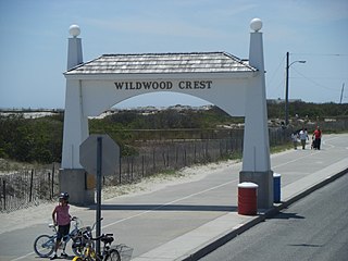
Wildwood Crest is a borough in Cape May County, in the U.S. state of New Jersey. The borough, and all of Cape May County, is part of the Ocean City metropolitan statistical area, and is part of the Philadelphia-Wilmington-Camden, PA-NJ-DE-MD combined statistical area, also known as the Delaware Valley or Philadelphia metropolitan area. As of the 2020 United States census, the borough's population was 3,101, a decrease of 169 (−5.2%) from the 2010 census count of 3,270, which in turn reflected a decline of 710 (−17.8%) from the 3,980 counted in the 2000 census.

<span class="mw-page-title-main">Lincroft, New Jersey</span> Populated place in Monmouth County, New Jersey, US

Lincroft is an unincorporated community and census-designated place (CDP) within Middletown Township, in Monmouth County, in the U.S. state of New Jersey. As of the 2020 United States census, the CDP had a population of 7,060, reflecting a 15.1% increase from the 6,135 residents enumerated at the 2010 U.S. Census, in turn a decline of 120 residents (-1.9%) from the 6,255 counted in the 2000 U.S. Census.

<span class="mw-page-title-main">Manahawkin, New Jersey</span> Populated place in Ocean County, New Jersey, US

Manahawkin is an unincorporated community and census-designated place (CDP) located within Stafford Township, in Ocean County, in the U.S. state of New Jersey. As of the 2020 United States census, the CDP's population was 2,413, its highest decennial count ever and an increase of 110 (+4.8%) from the 2,303 recorded at the 2010 census, which in turn had reflected an increase of 299 (+14.9%) from the 2,004 counted at the 2000 census. Manahawkin has been thought to be a Lenape word meaning "land of good corn", although this has been disputed by recent scholars claiming that it translates to "fertile land sloping into the water."

<span class="mw-page-title-main">Whitesboro, New Jersey</span> Populated place in Cape May County, New Jersey, US

Whitesboro is an unincorporated community and census-designated place (CDP) located within Middle Township in Cape May County, in the U.S. state of New Jersey. Until the 2000 census the area had been part of the Whitesboro-Burleigh CDP, which was split in 2010 into separate CDPs for Burleigh and Whitesboro. As of the 2010 United States Census, the CDP's population was 2,205. Whitesboro was founded as a planned residential community for African Americans and has the majority of the township's black population.

<span class="mw-page-title-main">Burleigh, New Jersey</span> Populated place in Cape May County, New Jersey, US

Burleigh is an unincorporated community and census-designated place (CDP) located within Middle Township in Cape May County, in the U.S. state of New Jersey; Until the 2000 census the area had been part of the Whitesboro-Burleigh CDP, which was split in 2010 into separate CDPs for Burleigh and Whitesboro. As of the 2010 United States Census, the CDP's population was 725.

<span class="mw-page-title-main">Belleplain, New Jersey</span> Populated place in Cape May County, New Jersey, US

Belleplain is an unincorporated community and census-designated place (CDP) located within Dennis Township in Cape May County, in the U.S. state of New Jersey. As of the 2010 United States census, the CDP's population was 597.

References

  1. "ArcGIS REST Services Directory". United States Census Bureau. Retrieved October 11, 2022.
  2. U.S. Geological Survey Geographic Names Information System: North Cape May Census Designated Place, Geographic Names Information System. Accessed October 18, 2012.
  3. 1 2 Census Data Explorer: North Cape May CDP, New Jersey, United States Census Bureau. Accessed June 15, 2023.
  4. Look Up a ZIP Code for North Cape May, NJ, United States Postal Service. Accessed October 18, 2012.
  5. 1 2 3 Gazetteer of New Jersey Places, United States Census Bureau. Accessed July 21, 2016.
  6. 1 2 U.S. Census website, United States Census Bureau. Accessed September 4, 2014.
  7. Geographic Codes Lookup for New Jersey, Missouri Census Data Center. Accessed June 9, 2023.
  8. US Board on Geographic Names, United States Geological Survey. Accessed September 4, 2014.
  9. State of New Jersey Census Designated Places - BVP20 - Data as of January 1, 2020, United States Census Bureau. Accessed December 1, 2022.
  10. New Jersey: 2010 - Population and Housing Unit Counts - 2010 Census of Population and Housing (CPH-2-32), United States Census Bureau, August 2012. Accessed October 18, 2012.
  11. 1 2 3 4 5 DP-1 - Profile of General Population and Housing Characteristics: 2010 Demographic Profile Data for North Cape May CDP, New Jersey Archived 2020-02-12 at archive.today , United States Census Bureau. Accessed October 18, 2012.
  12. Locality Search, State of New Jersey. Accessed April 19, 2015.
  13. Snyder, John P. The Story of New Jersey's Civil Boundaries: 1606-1968, Bureau of Geology and Topography; Trenton, New Jersey; 1969. p. 115. Accessed October 18, 2012.
  14. "Fifteenth Census of the United States: 1930 - Population Volume I", United States Census Bureau, p. 715. Accessed October 18, 2012.
  15. "Sixteenth Census of the United States: 1940 - Population Volume I; Number of Inhabitants", United States Census Bureau, p. 676. Accessed October 18, 2012.
  16. US Gazetteer files: 2010, 2000, and 1990, United States Census Bureau. Accessed September 4, 2014.
  17. Staff. 1980 Census of Population: Number of Inhabitants United States Summary, p. 1-141. United States Census Bureau, June 1983. Accessed June 28, 2015.
  18. 1 2 3 4 5 DP-1 - Profile of General Demographic Characteristics: 2000 from the Census 2000 Summary File 1 (SF 1) 100-Percent Data for North Cape May CDP, New Jersey Archived February 12, 2020, at archive.today , United States Census Bureau. Accessed October 18, 2012.
  19. "Lower Township Pool Offers Cool Relief from Heat Waves". Cape May County Herald . July 8, 2014. Retrieved May 20, 2021. - Press release
  20. Frequently Asked Questions, Cape May County Technical High School. Accessed October 27, 2019. "All residents of Cape May County are eligible to attend Cape May County Technical High School.... The Cape May County Technical High School is a public school so there is no cost to residents of Cape May County."
  21. Technical High School Admissions, Cape May County Technical High School. Accessed October 27, 2019. "All students who are residents of Cape May County may apply to the Technical High School."
  22. 1 2 3 Degener, Richard (September 23, 1993). "Propertied Class / Cape Christian Academy Buys Land For Central Campus". The Press of Atlantic City . pp. C1–C2. - Available from Newsbank, ID# news/0EAEAA6D18083359. Clipping of first and of second pages at Newspapers.com.
  23. "OBITUARIES (CAPE MAY, CUMBERLAND & OCEAN COUNTY EDITIONS)". The Press of Atlantic City . November 3, 1989. p. C3. Donations may be made to the South Cape Christian Academy, 123 Fishing Creek Road, North Cape May[...] - Available on Newsbank, ID# F0EAEA80A5401A343. Compare to the address of the North Cape May CDP, 2010.
  24. "Home". Cape Christian Academy. Retrieved July 15, 2021. 10 Oyster Road Cape May Court House, NJ 08210 - See map of CDP from the 2010 U.S. Census - page 1 and page 2. In contrast it is across from but not in the Burleigh CDP: Seen here.
  25. "Home". Our Lady Star of the Sea Catholic School. July 28, 2009. Archived from the original on July 28, 2009. Retrieved September 14, 2020.
  26. DiPasquale, Donna (June 22, 2010). "After 92 years, Star of the Sea School closes its doors". Cape Publishing, Inc. Retrieved September 11, 2020. - The author was the principal of Our Lady Star of the Sea Regional School.
  27. Franklin, Chris (June 4, 2020). "2 Jersey Shore Catholic schools slated to close have been saved". Nj.com . NJ Advance Media . Retrieved September 11, 2020.
  28. Avedissian, Eric. "A soldier’s story: Bob Andrzejczak lost a leg, not his resolve; The hardest part about the aftermath of attack in Iraq was not the pain ... it was calling home", Ocean City Sentinel, May 20, 2015. Accessed January 11, 2018. "Andrzejczak grew up in Lower Township in North Cape May, a bedroom community straddling the Delaware Bay."
  29. Weinberg, David "Cape musician Chris Jay forms unlikely friendship with Russian boxer Magomed Abdusalamov", The Press of Atlantic City , March 8, 2013. Accessed January 11, 2018. "The 34-year-old Lower Township native grew up in a musical household. Both of his parents, Ed and Lisa Jurewicz, are retired music teachers and own Mr. J's Music Shop in North Cape May, which is connected to their home."