
Arunachal Pradesh is a state in Northeast India. It borders the states of Assam and Nagaland to the south. It shares international borders with Bhutan in the west, Myanmar in the east, and a disputed border with China in the north at the McMahon Line. Itanagar is the state capital of Arunachal Pradesh. Arunachal Pradesh is the largest of the Seven Sister States of Northeast India by area.

East Siang is an administrative district in the state of Arunachal Pradesh in India.

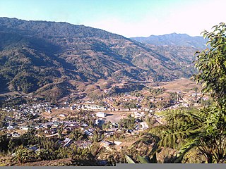
Pasighat is the headquarters of East Siang district in the Indian state of Arunachal Pradesh. Situated at the eastern foothills of the Himalayas at 155 meters (509 ft) above mean sea level, Pasighat is Arunachal's oldest town. The Government of India included Pasighat in the Smart Cities Mission development scheme in June 2017.

Yingkiong is a town and the administrative headquarter of Upper Siang district in the Northeast Indian state of Arunachal Pradesh. It is a small town located 250 kilometres (160 mi) to the north of Itanagar,which is the capital of Arunachal Pradesh. and around 1 kilometre (0.62 mi) east of the River Siang in Upper Siang district of Arunachal Pradesh. Yingkiong town is located at an elevation of 200 metres (660 ft) above sea level. To the west of Yingkiong flows the Siang River, which is geographically known by different other names based on region where it flows as the Brahmaputra River in the Assam Region and Yarlung Zangbo/Tsangpo in Tibet. According to the 2011 Census, the town has a total population of 8,573 persons.
Namsai is the headquarters of Namsai district in the Indian state of Arunachal Pradesh. This place is one of the 60 constituencies of Arunachal. Name of current MLA (August-2016) of Namsai constituency is Zingnu Namchoom.

Mechukha also Menchukha is a small town situated 6,000 feet (1,829 m) above sea level in the Mechukha Valley in Shi-Yomi District of Arunachal Pradesh, India. Name of current MLA (June-2019) of Mechuka constituency is Pasang Dorjee Sona. After Menchuka the McMahon border separates Indian territory and Chinese territory.
Palin is a hill station and the headquarter of Kra Daadi district in Arunachal Pradesh. It is inhabited by Nyishi tribe of Arunachal Pradesh and has a population of 5816 according to the 2001 census. The incumbent MLA from Palin constituency is Balo Raja.
Lower Siang is one of the 25 administrative districts in the state of Arunachal Pradesh, India. The new district was carved out of West Siang and East Siang districts and declared operational on 22 September 2017 and became the 22nd district of Arunachal Pradesh.

Siang District is the 21st district of Arunachal Pradesh State, India. This district was created by bifurcating West Siang and East Siang districts of Arunachal Pradesh consisting of 32-Rumgong-Kaying and 35-Boleng-Pangin Constituencies. The district was inaugurated on 27 November 2015 by Chief Minister Nabam Tuki.
Likabali, a town in the foothills, is the Headquarters of Lower Siang district of Arunachal Pradesh in the Arunachal Pradesh state of India. The town has a Vidhan Sabha constituency called 28th Likabali Legislative Assembly constituency. Presently, the Member of Legislative Assembly is Shri Kardo Nyigyor.<ref>"Likabali MLA". Archived from the original on 19 August 2016. Retrieved 14 August 2016.
Lokpeng is a village located in Pangin town of Siang district of Arunachal Pradesh in India.
Mebo is a Tehsil in the Indian state of Arunachal Pradesh. East Siang is the name of the district that contains Tehsil Mebo.
Tuting and Yingkiong are village and administrative town headquarters respectively of Upper Siang in the Indian state of Arunachal Pradesh. Upper Siang is the name of the district where the village Tuting and Yingkiong Town are located. The village was recently in spotlight due to Chinese People's Liberation Army incursion and construction of roads inside Indian territory. The village is under the administrative control of an additional deputy commissioner.
Along East is a place in the Indian state of Arunachal Pradesh. West Siang is the name of the district that contains Tehsil Along East.
Pasighat West is a place in the Indian state of Arunachal Pradesh. East Siang is the name of the district that contains Tehsil Pasighat West.
Pangin-Boleng is one of the 60 assembly constituencies of Arunachal Pradesh a north east state of India. Khonsa is part of Arunachal East Lok Sabha constituency.
Boleng is a small town in the Siang district in the Indian state of Arunachal Pradesh. It is located about 100 km away from Pasighat East Siang District of Arunachal Pradesh. It is the district HQ of Siang District.
Shi Yomi district is one of the 23 districts of Arunachal Pradesh state in northeastern India. Shi-Yomi district was created on 9 December 2018 by dividing the West Siang district when northern areas along the China border were made into a newly created Shi-Yomi district and the remaining southern areas remains the part truncated West Siang district. It has its headquarters at Tato.
