Panopticons

Last updated

Panopticons
Wycoller panopticon atom.jpg
Halo in Haslingden, Rossendale, England.jpg
Singing Ringing Tree (Panopticons).jpg
Colourfields.jpg
ArtistVarious
Subject Panopticon
Location Lancashire
Website midpenninearts.org.uk/programmes/panopticons

Panopticons is a series of four sculptures in Blackburn, Burnley, Pendle and Rossendale in Lancashire, England. They are part of an arts and regeneration project of the East Lancashire Environmental Arts Network managed by Mid Pennine Arts. The large scale outdoor sculptures were commissioned, designed and constructed over a six-year period. [1] [2] [3] [4]

Contents

The Halo in Haslingden, Rossendale was the last sculpture in the series to be erected, in September 2007. Plans for a similar sculpture in Accrington were never realised. [5] [6] One artist's impression showed a different design. [7]

Pantopicon sculptures

There are four sculptures in the Panopticons series:

The Atom in Pendle

The Atom Wycoller, Borough of Pendle Wycoller panopticon atom.jpg
The Atom Wycoller, Borough of Pendle

Set in the landscape of Pendle, the Atom was designed by Peter Meacock, Andrew Edmunds and Katarina Novomestska of Peter Meacock Projects. It was launched by Mayor of Pendle, Councillor George Adams, with Anthony Wilson and designer Peter Meacock, on 22 September 2006.[ citation needed ] The bronze coated glass fibre reinforced concrete structure provides both a work of art and a viewing point and shelter from which to enjoy the surrounding landscape.

Part of this sculpture, the metal ball inside, has since been vandalised and removed.[ citation needed ] Atom is located at 53°50′59″N2°05′48″W / 53.8496°N 2.0968°W / 53.8496; -2.0968 .

Colourfields, Blackburn

Colourfields in Blackburn Colourfields.jpg
Colourfields in Blackburn

Colourfields in Blackburn is a collaboration between Jo Rippon Architecture and artist Sophie Smallhorn. The design uses the former cannon battery in Corporation Park as its base. Colourfields was launched by the Mayor of Blackburn with Darwen, Councillor Dorothy Walsh, on the 14 June 2006. It's situated at 53°45′27″N2°29′51″W / 53.7575°N 2.4976°W / 53.7575; -2.4976 .

Haslingden Halo, Rossendale

The Haslingden Halo, Borough of Rossendale Halo in Haslingden, Rossendale, England.jpg
The Haslingden Halo, Borough of Rossendale

The Haslingden Halo is an artwork set on the expended landfill site (or "top 'o' slate") overlooking the town of Haslingden in Rossendale, positioned to be clearly visible from the M66 motorway and A56 road approach to Lancashire. It is located at grid reference SD791236 . The Halo was the fourth and final Panopticon to be constructed in Lancashire, and was launched in September 2007.

The Halo is an 18m diameter steel lattice structure supported on a tripod five metres above the ground. The core is open at the top, framing views of the sky. It is lit after dark, using low energy LEDs powered by an adjacent wind turbine, and glows a sky blue colour, giving the effect of hovering above the town. It was designed by John Kennedy of LandLab. The Halo in Haslingden has been controversial due to associated maintenance costs and tree felling. [2]

Singing Ringing Tree, Burnley

The Singing Ringing Tree, Burnley Singing Ringing Tree (Panopticons).jpg
The Singing Ringing Tree, Burnley

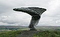
The Singing Ringing Tree is a musical sculpture overlooking Burnley. It was designed by architects Mike Tonkin and Anna Liu of Tonkin Liu, and constructed from pipes of galvanised steel. Singing Ringing Tree was launched by the Mayor of Burnley, Councillor Mohammad Najib, JP, and designers Mike Tonkin and Anna Liu on 14 December 2006. The sculpture is located at 53°45′23.90″N2°13′37.99″W / 53.7566389°N 2.2272194°W / 53.7566389; -2.2272194 .


Related Research Articles

<span class="mw-page-title-main">Lancashire</span> County of England

Lancashire is a ceremonial county in North West England. It is bordered by Cumbria to the north, North Yorkshire and West Yorkshire to the east, Greater Manchester and Merseyside to the south, and the Irish Sea to the west. The largest settlement is Blackpool, and Preston is the administrative centre.

<span class="mw-page-title-main">Burnley</span> Town in England

Burnley is a town and the administrative centre of the wider Borough of Burnley in Lancashire, England, with a 2001 population of 73,021. It is 21 miles (34 km) north of Manchester and 20 miles (32 km) east of Preston, at the confluence of the River Calder and River Brun.

<span class="mw-page-title-main">Borough of Rossendale</span> Borough and non-metropolitan district in Lancashire, England

Rossendale is a local government district with borough status in Lancashire, England. Its council is based in Bacup and its largest town is Rawtenstall. It also includes the towns of Haslingden and Whitworth. The borough is named after the Rossendale Valley, the upper part of the River Irwell.

<span class="mw-page-title-main">Hyndburn</span> Borough and non-metropolitan district in England

Hyndburn is a local government district with borough status in Lancashire, England. Its council is based in Accrington, the largest town, and the borough also covers the outlying towns of Clayton-le-Moors, Great Harwood, Oswaldtwistle and Rishton. The borough was created in 1974 and takes its name from the River Hyndburn. It had a population of 80,734 at the 2011 Census. Elections to the council are held in three out of every four years, with one third of the 35 seats on the council being elected at each election. Both the Conservative and Labour parties have controlled the council at different times, as well as periods when no party has had a majority.

<span class="mw-page-title-main">Borough of Burnley</span> Borough in Lancashire, England

The Borough of Burnley is a local government district with the borough status in Lancashire, England. It has an area of 42.7 square miles (110.7 km2) and a population of 94,721 (2021), and is named after its largest town, Burnley. The borough also contains the town of Padiham along with several villages and surrounding rural areas.

<span class="mw-page-title-main">Blackburn Hundred</span> Former sub-division of Lancashire, UK

Blackburn Hundred is a historic sub-division of the county of Lancashire, in northern England. Its chief town was Blackburn, in the southwest of the hundred. It covered an area similar to modern East Lancashire, including the current districts of Ribble Valley, Pendle, Burnley, Rossendale, Hyndburn, Blackburn with Darwen, and South Ribble.

<span class="mw-page-title-main">Haslingden</span> Town in Rossendale, Lancashire, England

Haslingden is a town in Rossendale, Lancashire, England. It is 16 miles (26 km) north of Manchester. The name means 'valley of the hazels' or 'valley growing with hazels'. At the time of the 2011 census the town had a population of 15,969. The town is surrounded by high moorland; 370 m (1215 ft) to the north; 396 m (1300 ft) Cribden to the east; 418 m (1372 ft) Bull Hill to the south.

<span class="mw-page-title-main">Rawtenstall</span> Town in Rossendale, Lancashire, England

Rawtenstall is a town in the borough of Rossendale, Lancashire, England. The town lies 15 miles north of Manchester, 22 miles east of Preston and 45 miles south east of Lancaster. The town is at the centre of the Rossendale Valley. It had a population of 23,000.

<span class="mw-page-title-main">Lancashire County Council</span> British administrative authority

Lancashire County Council is the local authority for the non-metropolitan county of Lancashire, England. It consists of 84 councillors. Since the 2017 election, the council has been under Conservative control. Before the 2009 Lancashire County Council election, the county had been under Labour control since 1989.

<span class="mw-page-title-main">River Calder, Lancashire</span> Tributary of the River Ribble in England

The River Calder is a major tributary of the River Ribble in Lancashire, England, and is around 20 miles (32 km) in length.

<span class="mw-page-title-main">River Ogden</span> River in Lancashire, England

The River Ogden is a minor river in Lancashire, England. It is approximately 4.4 miles (7.1 km) long and has a catchment area of 9.77 square miles (25.298 km2).

<span class="mw-page-title-main">River Laneshaw</span> River in Lancashire, England

The River Laneshaw is a river in Northern England. It runs for 1.9 miles (3 km) from Laneshaw Reservoir to Laneshaw Bridge alongside the A6068 road and has a catchment area of 5.1 square miles (13.2 km2).

<span class="mw-page-title-main">Yate and Pickup Bank</span> Civil parish in Blackburn with Darwen, Lancashire, UK

Yate and Pickup Bank is a civil parish in the borough of Blackburn with Darwen, Lancashire, England. The population of the civil parish taken at the census of 2011 was 366. The parish contains two hamlets, Bank Fold and Pickup Bank and part of the village of Belthorn which is on the boundary with Hyndburn. It has boundaries with the parishes of Eccleshill to the west and North Turton to the south.

<i>Singing Ringing Tree, Burnley</i> Sound sculpture in Lancashire, England

The Singing Ringing Tree is a wind powered sound sculpture resembling a tree set in the landscape of the Pennine hill range overlooking Burnley, in Lancashire, England.

<span class="mw-page-title-main">Honour of Clitheroe</span>

The Honour of Clitheroe is an ancient grouping of manors and royal forests centred on Clitheroe Castle in Lancashire, England; an honour traditionally being the grant of a large landholding complex, not all of whose parts are contiguous. In the case of Clitheroe, this complex was loosely clustered around the ancient wapentake of Blackburnshire.

<span class="mw-page-title-main">Hameldon Hill</span>

Hameldon Hill is a Carboniferous sandstone hill with a summit elevation of 409 metres (1,342 ft), situated between the towns of Burnley and Accrington in Lancashire, England. It is listed as a "HuMP" or "Hundred Metre Prominence", its parent being Freeholds Top, a Marilyn near Bacup.

<span class="mw-page-title-main">Borough of Pendle</span> Borough in England

Pendle is a local government district with borough status in Lancashire, England. The council is based in Nelson, the borough's largest town. The borough also includes the towns of Barnoldswick, Brierfield, Colne and Earby along with the surrounding villages and rural areas. Part of the borough lies within the Forest of Bowland Area of Outstanding Natural Beauty.

<span class="mw-page-title-main">2021 Lancashire County Council election</span> Election in the United Kingdom

An election to Lancashire County Council took place on 6 May 2021, with counting on 8 May, as part of the 2021 United Kingdom local elections. All 84 councillors are elected from electoral divisions for a four-year term of office. The system of voting used is first-past-the-post. Elections are held in all electoral divisions across the present ceremonial county, excepting Blackpool and Blackburn with Darwen which are unitary authorities.

References

  1. Anon (2024). "Panopticons, New landmarks for the 21st century". midpenninearts.org.uk. Archived from the original on 5 May 2017.
  2. 1 2 Anon (2005). "Haslingden Halo: 66 questions council should have asked: council bosses have been asked questions over their decision to approve the controversial Halo panopticon". rossendalefreepress.co.uk. Archived from the original on 27 September 2021.
  3. Anon (19 September 2006). "Item No. D7: Halo Panopticon" (PDF). rossendale.gov.uk. Rossendale Borough Council. Archived from the original (PDF) on 29 September 2006.
  4. Herbert, Ian (16 August 2008). "High art in Lancashire:One man and his dog leave the city behind to take in a view of the Pennine's panopticons -four new hilltop landmarks that are enchanting a growing number of visitors". independent.co.uk. The Independent. Archived from the original on 3 November 2012. Retrieved 6 June 2009.
  5. Anon (10 March 2005). "'Tide turns' on landmark". lancs.live. Archived from the original on 16 June 2021.
  6. "Firm 'no' to earthwork on Coppice". www.accringtonobserver.co.uk. 3 March 2005. Retrieved 16 July 2017.
  7. "Coppice is stunning exactly as it is ..." www.accringtonobserver.co.uk. 3 February 2005. Retrieved 16 July 2017.