Hermanville is a census-designated place and unincorporated community in Claiborne County, in southwest Mississippi, United States. Its ZIP code is 39086.
Arkabutla is a census-designated place and unincorporated community in Tate County, Mississippi, United States. Arkabutla is located approximately 9 miles (14 km) west of Coldwater and approximately 9 miles (14 km) north of Strayhorn. It also lies approximately 4 miles (6.4 km) south of the dam at Arkabutla Lake. Although an unincorporated community, it has a post office and a zip code of 38602.
Mississippi State is a census-designated place in Oktibbeha County, Mississippi, United States. It is the official designated name for the area encompassing Mississippi State University, which lies partly in the nearby incorporated municipality of Starkville. The population at the 2020 census was 4,968.

Valley Park is a census-designated place and unincorporated community in Issaquena County, Mississippi, United States. Its elevation is 95 feet. Although unincorporated, it has a post office, with the ZIP code of 39177.
Delta City is a census-designated place and unincorporated community located on Mississippi Highway 434 in Sharkey County, Mississippi. Delta City is approximately 6 miles (9.7 km) east of Panther Burn and approximately 5 miles (8.0 km) north of Nitta Yuma. Although an unincorporated community, Delta City has a zip code of 39061.

Dublin, also known as Hopson Bayou, is a census-designated place and unincorporated community located along U.S. Route 49 in southeastern Coahoma County, Mississippi, United States. Dublin is located on the Mississippi Delta Railroad. Dublin has a ZIP code of 38739. A post office first began operation under the name Dublin in 1875.
Ovett is a census-designated place and unincorporated community in southeastern Jones County, Mississippi. Ovett is part of the Laurel Micropolitan Statistical Area.

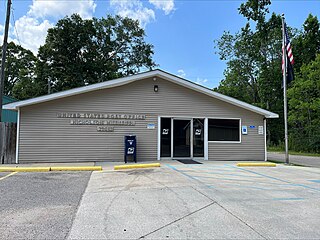
Moselle is a census-designated place and unincorporated community in southern Jones County, Mississippi. The community is part of the Laurel micropolitan area.

Eastabuchie is a census-designated place and unincorporated community in southwestern Jones County, Mississippi. It is located along U.S. Route 11, just north of the Forrest County line. the community has a post office with the ZIP code 39436. Eastabuchie is part of the Laurel Micropolitan Statistical Area.
Grace is a census-designated place and unincorporated community in Issaquena County, Mississippi, United States. It is located several miles northeast of Mayersville.

Nitta Yuma is a census-designated place and unincorporated community located in Sharkey County, Mississippi, United States. Nitta Yuma is located along U.S. Route 61, approximately four miles north of Anguilla.

Farrell is an unincorporated community and census-designated place in Coahoma County, Mississippi, United States. Per the 2020 census, the population was 200. Farrell is located approximately 4 miles (6 km) south of Stovall and 4 miles (6 km) north of Sherard on Mississippi Highway 1. It is approximately 9 miles (14 km) northwest of Clarksdale, the county seat.
Independence is a census-designated place and unincorporated community in Tate County, Mississippi, United States.
Nicholson is an unincorporated community and census-designated place (CDP) in Pearl River County, Mississippi, United States. As of the 2020 census, its population was 2,833. Its ZIP code is 39463.
Wheeler is a census-designated place and unincorporated community in Prentiss County, Mississippi, United States. Its ZIP code is 38880.
New Site is a census-designated place and unincorporated community in Prentiss County, Mississippi, United States. Its population was 851 at the 2010 U.S. Census. Its ZIP code is 38859.
Pattison, also known as Martin, is a census-designated place and unincorporated community in Claiborne County, Mississippi, United States. Its ZIP code is 39144.
Hillsboro is an unincorporated community and census-designated place (CDP) in Scott County, Mississippi, United States. Its population was 1,130 as of the 2010 census. Hillsboro has a post office with ZIP code 39087.
Harperville is a census-designated place and unincorporated community in rural Scott County, Mississippi, United States. Harperville is located on Mississippi Highway 35, 9 miles (14 km) north of Forest. Harperville has a post office with ZIP code 39080. It was first named as a CDP in the 2020 Census which listed a population of 250.
Bethlehem is a census-designated place and unincorporated community in Marshall County, Mississippi, United States. Its ZIP code is 38659.


