Park View was developed at the turn of the 19th and 20th centuries, along the western boundary of the U.S. Soldiers' Home. The name of the neighborhood is derived from its relation to the park-like setting of the Soldier's Home, which was formerly open to the public as a park into the 1960's.
Geography
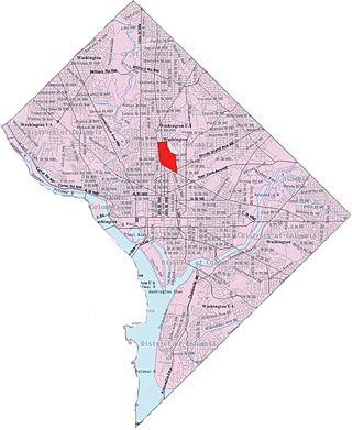
Park View is situated in the Northwest quadrant of the city. The territory that defines the Park View neighborhood extends from Gresham Place north to Rock Creek Church Road, and from Georgia Avenue to the Soldiers' Home grounds. The additional area bounded by Park Road, New Hampshire Avenue, and Georgia Avenue completes the neighborhood's boundaries.[1] The southern border of the Park View Citizens' Association was Columbia Road.[2] Sherman Avenue is considered by some to be the western boundary of the neighborhood.
The majority of Park View falls within Tract 32 of the 188 Census Tracts in the District of Columbia, which counted 5,099 residents in 2020 vs. 4,913 in 2010, an increase of 3.8%. Previous to there was a 9.7% increase in population from 2000 to 2010.
Ethnically and racially, the area has become less Black and more White and multi-racial from 2010 to 2020. In 2020 there were 35% fewer non-Hispanic Blacks than in 2010, dropping from 2,836 to 1,834 and they formed the plurality of residents, but no longer the majority. The Non-Hispanic White population increased 118% from 723 to 1,576 and they became the second-largest group, taking that position from Hispanics and Latinos. The neighborhood's population was in 2020 was 36.0% non-Hispanic (NH) Black (vs. 57.7% in 2010), 30.9% NH White (up from 14.7% in 2010), 23.5% Hispanic or Latino (vs. 24.2% in 2010), 4.1% NH Asian vs. 1.9% in 2010; 0.08% NH American Indian and Alaska Native vs. 0.28% in 2010; 1.0% NH some other race vs. 0.2% in 2010, and 4.5% NH multiracial vs. 1.0% who identified as such in 2010.[5]
According to the Census Bureau's American Community Survey (2005–09), the average family income was $70,231. This was up 22% from the 2000 census numbers. The same survey reported the unemployment rate in Park View to be 9.6%. Employment for residents 16 years of age or older was 63% at that time.[6]
Political representation
Politically, Park View is in D.C.'s Ward 1 and falls within Advisory Neighborhood Commission 1A (ANC1A). Three ANC1A Single Member Districts represent the neighborhood. ANC 1A08 represents the northern section, central Park View is represented by ANC 1A09, and ANC 1A10 serves the southern third of the neighborhood.[7]
History
3567 and 3569 Warder Street, NW. These two houses date to 1893 and are the sole remaining houses from the Whitney Close subdivision.
The transition of the rural community to the west of the Soldiers' Home into Washington's Park View neighborhood dates to June 4, 1886. On that date, the heirs of Catherine M. Whitney sold the former estate of Asa Whitney, known as Whitney Close, to Benjamin H. Warder of Ohio for the sum of $60,024. Warder immediately set about subdividing the 43-acre tract of land into building lots for a new community.[8] This was followed by the subdivision and development of other country properties in the area. These subdivisions—including Whitney Close, Schuetzen Park, and Bellevue—were organized into a single neighborhood known as Park View in 1908.[9] Park View eventually included the subdivision of Princeton Heights to the north to round out the neighborhood boundaries. Since the neighborhood abutted the grounds of the Soldiers' Home, and as the grounds were open to the public as a courtesy, the name Park View was chosen to signify the close relationship between these two communities.
The Soldiers' Home Grounds were important in the early life of Park View. The Soldiers' Home granted permission to the neighborhood to hold their Fourth of July celebrations there in 1917 and 1918.[10][11] Neighborhood children would play on the grounds and sail toy boats on the ponds. Picnics and long walks were also frequent pastimes, with the view of the city and the Capitol being unparalleled.
Reflecting the social changes occurring in the entire city of Washington, Park View desegregated at the end of the 1940s. Black families began to move into the northern part of the neighborhood around 1946. Eventually, the neighborhood became a solidly African American community and remained this way for a period of over 30 years. Following the Georgia Avenue-Petworth Metro Station opening in 1999 the neighborhood began to change yet again and today can be considered truly multicultural.
The relationship between the neighborhood and the Soldiers' Home began to change during the early 1950s. In response to losing part of its property to the south for the Washington Hospital Center, the Soldiers' home began closing its southern gates from 1953 to 1955.[12][13] Eventually, its grounds were officially closed to residents of the neighborhoods entirely in November 1968, thus depriving the community of the only real green space it had ever known.[14]
Georgia Avenue
Georgia Avenue is the commercial artery of Park View. It was built in 1810 which makes it one of Washington's oldest thoroughfares connecting the city of Washington with nearby communities. It was originally known as the 7th Street Turnpike and connected Washington with Rockville, Md., leaving the city from its northern boundary where 7th Street crosses today's Florida Avenue. It was renamed Georgia Avenue in 1908 after Georgia Senator Augustus Octavius Bacon pushed an amendment through Congress for that purpose.[15]
Architectural and cultural sites of interest
Tenth Precinct Station House
Tenth Precinct Station House, DC
The Tenth Precinct Station House, located at 750 Park Road, was designed by A.B. Mullett and Company and built in 1901. It is significant for its architectural character and its historical association with the police department of the District of Columbia in the late nineteenth and early twentieth centuries. The designation of the Tenth Precinct and the construction of the police station in 1901 were responses to the expansion of the city limits and urban population into this area. Reforms in the D.C. police department in the latter decades of the nineteenth century had led to the enlargement of the force and creation of new precincts.
The street system in the area north of Florida Avenue (formerly Boundary Street) had been surveyed by 1901, but few buildings had been constructed. By 1910, the block from Sherman Avenue to Georgia Avenue, in which the station house is located, was almost fully occupied by tradesmen and workers. The station house, assessed at $13,000, was by far the most imposing building on the block in which most of the properties were assessed at less than $1,000. Its imposing character in relation to the residential environs as well as its architectural quality suggested the importance of symbolic expression of authority. This expression is characteristic of the City Beautiful movement, a growing belief at the turn of the century that public structures should be imposing, monumental and of classical style.
Until 1886, the D.C. police department had been charged with corruption, political partisanship and venality. Subsequent reforms led to the enlargement of the force and creation of new precincts. Each station house was staffed by a captain, a lieutenant and several sergeants. The station house was the first facility to which an arrested man or woman was brought. At the station house, the arrest was recorded, and the prisoner was confined there until released on bail or removed, to police court for trial or to jail to await grand jury testimony. Misdemeanors were handled at the station house; felonies were dealt with in D.C. Supreme or Police Court.
The old Whitney Avenue Christian Church which had been built in 1877 was replaced in 1920. At that time, it was among the oldest landmarks in Park View. The church, located at 625 Park Road, was the location of the earliest efforts to form the Park View community and build the new school on Warder.
In 1920, the old church was replaced with the building that is there now. The new building was renamed the Park View Christian Church and built at a cost of $30,000.[17]
The congregation of the Park View Christian Church eventually moved to Shepherd Park, and the Trinity A.M.E. Zion Church moved to 625–627 Park Rd. in 1944. The structure supported Trinity's congregation until 1983, when Trinity moved to its current location on 16th Street.
The school located at the intersection of Warder and Newton streets was built in 1916 to designs by Snowden Ashford. The origin of the school can be traced back to the efforts of the Park View Citizens' Association and their persistent appeal to Congress for funds to purchase the land and build the school. Ashford designed the school in his preferred style of Collegiate Gothic. The interior is notable for the wooden truss that supports the auditorium roof.
It is constructed of red tapestry brick with trimmings of Bedford limestone and was built on some of the highest ground in the city. Originally a 16-room structure, the school quickly became too small for the needs of the community. In 1920 the progressive platoon school model was adopted which helped address the school's space problem. Two wings were finally added to the building and ready for use by 1931.
By the late 1940s, the racial makeup of the neighborhood had changed from predominantly white to predominantly black. As black schools were overcrowded and white schools were under-enrolled, Park View was transferred to the black division in 1949.[19][20][21]
The school is still in use today as a District of Columbia Public Elementary School.
Princeton Heights Development
The section of Park View north of Otis, south of Rock Creek Church Road, and between Georgia Avenue and the Soldiers' Home was first developed as Princeton Heights. This area was originally the estate of the Cammack family, which was sold by the heirs in 1908 to builder Edgar S. Kennedy, who would eventually be associated with the Kennedy–Warren. Between 1909 and 1919, Kennedy subdivided the estate, put in roads, and built 162 contiguous homes in 20 separate rows. Kennedy's homes were known for their quality, non-static facades, and inclusion of progressive features. In 1919, Kennedy sold the unimproved land between Princeton Place and Otis Place to Herman R. Howenstein, who completed the development.[22]
York Theater
The York Theater at night, photographed ca. 1920
The York Theater, located at 3635–3641 Georgia Avenue, was designed by Reginald W. Geare as one of Harry Crandall's chain of theaters. Kennedy Brothers were hired as the builders, and it was one of the last two structures built by Kennedy in the Princeton Heights development. While newspaper accounts reported the theater to cost $100,000 to build, the estimate on the building permit valued the project at $50,000. The front of the structure was constructed of tapestry brick and trimmed with white stone and marble. Inside, the proscenium hangings were of rich gold velour enlivened with blue medallions and white figures in relief. Newspaper accounts also described the lighting system as unique.
The structure was in use as a theater as late as May 1954. It was purchased by the National Evangelistic Center in May 1957 and has been used as a church since them. Today, it is home of the Fishermen of Men Church.[23]
Development
Despite the early promise of development coming to Park View's section of Georgia Avenue when Temperance Hall opened at 3634 Georgia Avenue in January, 2006,[24] it was not until 2009 that significant development began to take hold. Temperance Hall changed hands in early 2008 becoming the Looking Glass Lounge. In stark contrast, 2009 witnessed the groundbreaking of three major projects and the selection of a developer for a fourth.
Starting on August 10, 2009, the district began to demolish the 37-year-old Bruce-Monroe school with the goal of replacing it with a modern facility.[25] Financing for a new school building continued to be difficult and the district's hope to develop the site as a mixed use public/private venture fell apart late in 2010. During this time, the 3-acre (12,000m2) site was transformed into an interim park that opened to the community at the end of July, 2010.[26] With building a new school no longer an option, the district decided to move forward with modernizing the historic Park View School to meet the area's elementary school needs.[27]
The Bernice E. Fonteneau Senior Wellness Center (Ward One Senior Wellness Center), located at 3531 Georgia Avenue, broke ground on October 14, 2009.[28] The $5.2 million facility, containing 15,000 square feet (1,400m2) of space on three floors, had its official ribbon cutting on September 10, 2010, and was officially open for business on February 28, 2011, and dedicated in honor of Bernice E. Fonteneau on May 25, 2011.[29][30][31]
The last building to break ground in 2009 was the CVS located on the southwest corner of Georgia and New Hampshire Avenues, which broke ground on November 12.[32] The CVS was completed and open for business on July 25, 2010,[33] with an official ribbon cutting ceremony attended by Mayor Adrian Fenty, councilmembers Jim Graham and Murial Bowser, deputy mayor for planning and economic development Valerie Santos, and other representatives from CVS and the developer LaKritz/Adler[34] on July 27, 2010.
Building projects in Washington, including Georgia Avenue, stalled in 2010 due to the economy, but picked up again in 2011. In Park View, the resumption of development included Landex Corporation's The Avenue and Neighborhood Development Company's The Heights. The Avenue broke ground in April 2011 and was hailed as the first phase of the new Park Morton housing community.[35] The Avenue was designed as an 83-unit mixed-use apartment building. Located at 3506 Georgia Avenue, NW, the building contains 81,044 square feet of residential space and 2,388sqft (221.9m2) of ground floor retail. It also includes a mix of one and two-bedroom apartment units. Residential space features a lounge, a fitness center, meeting rooms, and underground parking.[36] The building opened with an official ribbon cutting on September 21, 2012.[37]
The Heights broke ground in January 2012.[38] The Heights, located at 3232 Georgia Avenue was designed as a mixed use development designed to contain 69 units with 10,000sqft (930m2) of ground floor retail.[39] The project was completed in May 2013 and opened with a ribbon cutting on May 8, 2013.[40]
Ground was also broken at the vacant lot at 3205 Georgia Avenue in April 2013.[41] Currently under construction, the building is planned to have five floors and 31 1- and 2-bedroom rental units. Floors two through five will each have seven apartments. The first floor will have three.[42]
Another major development planned for Georgia Avenue is the redevelopment of the Park Morton housing complex. Mayor Fenty announced the selection of Landex Corp. to redevelop the Park Morton complex on October 7, 2009.[43] The first phase of the development, at 3506 Georgia, was completed in September 2012.
Two additional project are also in the works: The Vue by Neighborhood Development Company and The V by Velocity Capital. The Vue, at 3333 Georgia Avenue, is planned to rise seven-stories above the 7,000sqft (650m2) ground floor retail and offer 112 residences. Forty-nine parking spaces will be provided below grade.[44]
The V, located at 3557 Georgia, is a six-story mixed-use project that consists of ground floor retail and twenty dwelling units above. The proposed retail space would contain approximately 2,138sqft (198.6m2) and would be appropriate for a café. The Otis Place side of the property could also support 530sqft (49m2) of outdoor seating should a future tenant apply for a public space permit. The residential units would consist of ten one-bedroom and ten two-bedroom units. The exact number that will be dedicated for affordable housing is not known, but the developer has indicated it would be more than the city required minimum.[45]
Real estate
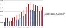
Median sales price for single-family homes in DC Census Tract 32 (Park View)
According to Housing Market (Single-Family Homes) statistics for 2011, 46 homes sold in Park View (census Tract 32). The median sales price for a home was $430,000, below the district average of $527,000.[6]
Transportation
The community is well served by two Metrorail stations. Both stations are on the Yellow and Green lines. The most convenient for northern Park View is the Georgia Avenue–Petworth station which is situated at the northeast corner of Georgia and New Hampshire Avenues and just over the Park View border in Petworth. Central Park View is best served by the Columbia Heights station located at the intersection of Irving and 14th Streets—three blocks west of the neighborhood. The area is also served by a number of WMATA Metrobus lines.
In late October, 2009, DDOT held its first of the series of eight meetings focused on DC's transit future.[47] At these meetings DDOT presented its plans for an extensive streetcar system it is planning to build in the city. Two of these planned lines would serve Park View. The first line would travel along Georgia Avenue and is included in DDOT's first phase plans. The second line would travel through the neighborhood along Irving Street and Columbia Road and is included in DDOT's third phase of the plan.[48] Detailed plans for the streetcar system are yet to be completed.
Boese, Kent C., edited by Mara Cherkasky and designed by Janice Olson. Historic Park View: A Walking Tour. Washington, DC: Park View United Neighborhood Coalition, 2012.
Boese, Kent C., Lauri Hafvenstein. Park View. Charleston, SC: Arcadia Pub., 2011.
Adams Morgan is a neighborhood in Washington, D.C., located in Northwest D.C. Adams Morgan is noted as a historic hub for counterculture and as an arts district. It is also known for its popular entertainment district and culinary scene, centered on both 18th Street and Columbia Road.
Tenleytown is a historic neighborhood in Northwest, Washington, D.C.
Georgia Avenue–Petworth station is a Washington Metro station in Washington, D.C., on the Green Line. It is located at the border of the neighborhoods of Petworth, Sixteenth Street Heights, and Park View in Northwest.
Northwest is the northwestern quadrant of Washington, D.C., the capital of the United States, and is located north of the National Mall and west of North Capitol Street. It is the largest of the four quadrants of the city, and it includes the central business district, the Federal Triangle, and the museums along the northern side of the National Mall, as well as many of the District's historic neighborhoods.
The Palisades, or simply Palisades, is a neighborhood in Washington, D.C., along the Potomac River, running roughly from the edge of the Georgetown University campus to the D.C.-Maryland boundary.
Columbia Heights is a neighborhood in Washington, D.C., located in Northwest D.C. The neighborhood is an important retail hub for the area, as home to DC USA mall and to numerous other restaurants and stores, primarily along the highly commercialized 14th Street. Columbia Heights is home to numerous historical landmarks, including Meridian Hill Park, National Baptist Memorial Church, All Souls Church, along with a number of embassy buildings.
Cleveland Park is a residential neighborhood in the Northwest quadrant of Washington, D.C. It is located at 38°56′11″N77°3′58″W and bounded approximately by Rock Creek Park to the east, Wisconsin and Idaho Avenues to the west, Klingle and Woodley Roads to the south, and Rodman and Tilden Streets to the north. Its main commercial corridor lies along Connecticut Avenue NW, where the eponymous Cleveland Park station of the Washington Metro's Red Line can be found; another commercial corridor lies along Wisconsin Avenue. The neighborhood is known for its many late 19th century homes and the historic Art Deco Uptown Theater. It is also home to the William L. Slayton House and the Park and Shop, built in 1930 and one of the earliest strip malls.
Brookland, also known as Little Rome or Little Vatican, is a neighborhood located in the Northeast (NE) quadrant of Washington, D.C. It is best known for its numerous Catholic institutions, including schools, religious communities, shrines, institutes, and other organizations built and based around the Catholic University of America.
Wesley Heights is a small affluent neighborhood of Washington, D.C. situated south of Spring Valley. Wesley Heights was founded in 1890 by a land speculation group led by John Waggaman and funded primarily by Charles C. Glover; Wesley Heights was further developed by the brothers William C. and Allison N. Miller during the 1920s. Modern-day Wesley Heights is bordered by Massachusetts Avenue, Nebraska Avenue, Battery-Kemble Park and Glover Parkway. Foxhall Road and New Mexico Avenue are the main roadway passing through Wesley Heights. To protect the character of the original historic housing design of Wesley Heights, the Wesley Heights Zoning Overlay was developed and approved by District of Columbia Zoning Commission on July 13, 1992, at the urging of the Wesley Heights Historical Society. Current homeowners and new housing development within the Wesley Heights overlay must meet specific building codes. The Wesley overlay covers areas west of New Mexico Avenue, Nebraska Avenue, Battery-Kemble Park and Glover Parkway. The overlay restriction does not cover development on housing located on the former Charles C. Glover country estate. Modern day Wesley Heights is located in Ward 3 Advisory Neighborhood Commission under 3D01.
Takoma, Washington, D.C., is a neighborhood in Washington, D.C. It is located in Advisory Neighborhood Commission 4B, in the District's Fourth Ward, within the northwest quadrant. It borders the city of Takoma Park, Maryland.
Petworth is a residential neighborhood in the Northwest quadrant of Washington, D.C. It is bounded to the east by the Armed Forces Retirement Home and Rock Creek Cemetery, to the west by Arkansas Avenue NW, to the south by Rock Creek Church Road NW and Spring Road NW, and to the north by Kennedy Street NW.
Brightwood is a neighborhood in the northwestern quadrant of Washington, D.C. Brightwood is part of Ward 4.
Pleasant Plains is a neighborhood in central Washington, D.C. largely occupied by Howard University. For this reason it is also sometimes referred to as Howard Town or, less frequently, Howard Village.
Woodley Park is a neighborhood in Northwest, Washington, DC. It is bounded on the north by Woodley Road and Klingle Road, on the east by the National Zoo and Rock Creek Park, on the south by Calvert Street, on the southwest by Cleveland Avenue, and on the west by 34th Street.
Northeast Boundary is small neighborhood located in the northeast quadrant of Washington, D.C., in the United States. Along with the Capitol View neighborhood, it is the easternmost neighborhood of the District of Columbia.
Pleasant Hill is a neighborhood located in Ward 5 of Northeast Washington, D.C. Pleasant Hill is contained between Allison Street NE and Bates Road NE to the north, Taylor Street NE to the south, the Washington Metropolitan Area Red Line tracks to the east, and North Capitol Street NW to the west. Pleasant Hill borders the adjacent neighborhoods of Fort Totten (north), North Michigan Park (northeast), Michigan Park (east), University Heights (south), Petworth (west), Brightwood Park (northwest), and Park View (southwest). It is adjacent to the Catholic University of America and even houses its athletic facilities. Pleasant Hill houses the Catholic University of America's soccer and football fields as well as its Raymond A. DuFour Athletic Center.
Sixteenth Street Heights is a large neighborhood of rowhouses, duplexes, and American Craftsman and American Foursquare detached houses in Northwest Washington, D.C.
Fort Stevens Ridge is a neighborhood in Northwest Washington, D.C. built during the 1920s. The neighborhood comprises about 50 acres (0.20 km2) and is very roughly bounded by Peabody Street, Fifth Street, Underwood Street, and Ninth Street. As of the 2010 census, the neighborhood had 2,597 residents. It was named for nearby Fort Stevens, a Civil War-era fort used to defend the nation's capital from invasion by Confederate soldiers.
Martin Luther King Jr. Avenue is a major street in the District of Columbia traversing through both the Southwest and Southeast quadrants.
The Petworth Neighborhood Library is a branch of the District of Columbia Public Library in the Petworth neighborhood of Washington, D.C. It is located at 4200 Kansas Avenue NW.
References
↑ Park View Citizens' Association. Directory and History of Park View, 1921. p. 29.
↑ "Park View Citizens Association Has Won Benefits for Many Areas Besides Its Own", The Washington Post, Nov. 11, 1940. p. 13.
↑ Headley, Robert K. Motion Picture Exhibition in Washington, D.C.: An Illustrated History of Parlors, Palaces and Multiplexes in the Metropolitan Area, 1894–1997. Jefferson, N.C., McFarland & Co., 1999. p. 343.
This page is based on this Wikipedia article Text is available under the CC BY-SA 4.0 license; additional terms may apply. Images, videos and audio are available under their respective licenses.