
Hornchurch is a suburban town in East London, England, and part of the London Borough of Havering. It is located 15.2 miles (24.5 km) east-northeast of Charing Cross. It comprises a number of shopping streets and a large residential area. It historically formed a large ancient parish in the county of Essex that became the manor and liberty of Havering. The economic history of Hornchurch is underpinned by a shift away from agriculture to other industries with the growing significance of nearby Romford as a market town and centre of administration. As part of the suburban growth of London in the 20th century, Hornchurch significantly expanded and increased in population, becoming an urban district in 1926 and has formed part of Greater London since 1965. It is the location of Queen's Theatre, Havering Sixth Form College and Havering College of Further and Higher Education.

The London Borough of Havering in East London, England, forms part of Outer London. It has a population of 259,552 inhabitants; the principal town is Romford, while other communities are Hornchurch, Upminster, Collier Row and Rainham. The borough is mainly suburban, with large areas of protected open space. Romford is a major retail and night time entertainment centre, and to the south the borough extends into the London Riverside redevelopment area of the Thames Gateway. The name Havering is a reference to the Royal Liberty of Havering which occupied the area for several centuries. The local authority is Havering London Borough Council. It is the easternmost London borough.
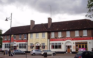
Elm Park is a suburban planned community in East London within the London Borough of Havering. Located 14.3 miles (23.0 km) east-northeast of Charing Cross, it is identified as a district centre in the London Plan with several streets of shops and a priority for regeneration. Prior to the construction of the extensive Elm Park Garden City development in the 1930s it was a scattered settlement of farms in the south of the parish of Hornchurch. Elm Park has been connected to central London by the electrified District line service since 1935 and the planned development of the area formed part of the interwar private housing boom that was interrupted by World War II. After the war Elm Park expanded with social housing and it has formed part of Greater London since 1965.

Medway is a unitary authority district and conurbation in Kent, South East England. It had a population of 278,016 in 2019. The unitary authority was formed in 1998 when Rochester-upon-Medway amalgamated with the Borough of Gillingham to form Medway Towns. It is now a unitary authority area run by Medway Council, independent of Kent County Council but still part of the ceremonial county of Kent.

Rainham is a town in the unitary authority of Medway, in Kent, South East England. The town forms a conurbation with neighbouring towns Chatham, Rochester, Strood and Gillingham.

Hornchurch was a borough constituency represented in the House of Commons of the Parliament of the United Kingdom. It elected one Member of Parliament (MP) by the first past the post system of election. At the 2010 general election parts formed the new seats of Hornchurch and Upminster; and Dagenham and Rainham.

Hornchurch was a local government district in southwest Essex from 1926 to 1965, formed as an urban district for the civil parish of Hornchurch. It was greatly expanded in 1934 with the addition of Cranham, Great Warley, Rainham, Upminster and Wennington; and in 1935 by gaining North Ockendon. Hornchurch Urban District Council was based at Langtons House in Hornchurch from 1929. The district formed a suburb of London and with a population peaking at 131,014 in 1961, it was one of the largest districts of its type in England. It now forms the greater part of the London Borough of Havering in Greater London.
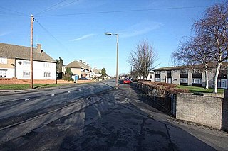
South Hornchurch is a locality to the south of Hornchurch in London Borough of Havering, east London. It is a suburban development situated 13.6 miles (21.8 km) east of Charing Cross. The area is a relatively recent addition, compared with the more mature suburbs in Havering. It was built on open farmland and the former site of RAF Hornchurch.

Rainham Marshes is an RSPB nature reserve in the east of London, adjacent to the Thames Estuary in Purfleet, Thurrock and the London Borough of Havering. In 2000, the area of land was bought from the Ministry of Defence, who used it as a test firing range. With no activity for several years, the nature reserve was officially opened to the public in 2006. It has maintained much of its medieval landscape, and is the largest area of wetland on the upper parts of the Thames Estuary.

Gillingham and Rainham is a constituency in Kent represented in the House of Commons of the UK Parliament since its 2010 creation by Rehman Chishti, a Conservative. It replaced the previous constituency of Gillingham.

Hempstead is a village near Gillingham, Kent in South East England. Historically a small hamlet, Hempstead grew throughout the 20th century to become part of the urban area of the Medway Towns. Hempstead is located on the southern edge of the Unitary authority of Medway, surrounded by Wigmore and the A278 trunk road to the east, Capstone valley to the west and the M2 motorway and the village of Bredhurst to the south. Most of Hempstead is in a valley, with Hempstead Valley Drive running along its length with housing on both sides.
Parkwoods or sometimes referred to as Parkwoods-Donalda, is a neighbourhood in Toronto, Ontario, Canada. It is a geographically large neighbourhood located just south of Ontario Highway 401, west of Victoria Park Avenue, north of Lawrence Avenue East and east of the Don Valley Parkway.

Parkwood is a neighborhood located in the Far Northeast section of Philadelphia, Pennsylvania, United States. The neighborhood's boundaries include the Byberry East Industrial Park to the north and northwest, Poquessing Creek to the east, Knights Road to the southeast and Woodhaven Road to the southwest. The neighborhood was developed by Hyman Korman in the 1960-1962 as a planned residential community. The predominant housing type is the brick row house. The Parkwood Shopping Center is a local shopping destination, while the Philadelphia Mills mall is a regional shopping destination on Knights Road to the east of Parkwood's residential area.
Park Wood is a suburb of Maidstone, Kent.
Riverside Terrace is a neighborhood in Houston, Texas, United States. It is along Texas State Highway 288 and north of the Texas Medical Center and located near Texas Southern University and University of Houston. There about 20 sections of Riverside Terrace that span across North and South MacGregor. The community, formerly an affluent Jewish neighborhood, became an affluent community for African Americans in the 1950s and '60s. It is still predominantly African American neighborhood with different income levels. It has been undergoing a gradual change in demographics and aesthetics due to gentrification efforts since the early 2000s.

Rainham is a suburb of East London, England, in the London Borough of Havering. Historically an ancient parish in the county of Essex, Rainham is 13.6 miles (21.9 km) east of Charing Cross and is surrounded by a residential area, which has grown from the historic village, to the north and a commercial area, fronting the River Thames, to the south. As part of the suburban growth of London in the 20th century, Rainham significantly expanded and increased in population, becoming part of Hornchurch Urban District in 1934, and has formed part of Greater London since 1965. The economic history of Rainham is underpinned by a shift from agriculture to industry and manufacture and is now in a period of regeneration, coming within the London Riverside section of the Thames Gateway redevelopment area.
Parkway Park is a neighbourhood in College Ward in Ottawa, Ontario, Canada. It is bounded to the north by the Queensway, to the west by Cobden Road, to the south by Baseline Road and to the east by Pinecrest Creek and the OC Transpo Transitway.

