Parlin, Colorado

Last updated

Parlin, Colorado
Parlin, Colorado.JPG
Entering Parlin
USA Colorado location map.svg
Red pog.svg
Parlin
Usa edcp location map.svg
Red pog.svg
Parlin
Coordinates: 38°30′11″N106°43′34″W / 38.50306°N 106.72611°W / 38.50306; -106.72611
CountryFlag of the United States.svg  United States
State Flag of Colorado.svg  State of Colorado
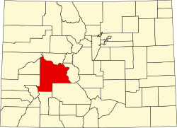
County Gunnison County [1]
Elevation
[1]
7,933 ft (2,418 m)
Time zone UTC-7 (MST)
  Summer (DST) UTC-6 (MDT)
ZIP code [2]
81239
GNIS feature ID 0189019

Parlin is an unincorporated community and a U.S. Post Office in Gunnison County, Colorado, United States. The Parlin Post Office has the ZIP Code 81239. [2]

Contents

Geography

Parlin is located at 38°30′11″N106°43′34″W / 38.50306°N 106.72611°W / 38.50306; -106.72611 (38.503042, -106.726170).

History

The town is named after rancher John Tufts Parlin who moved to the area from Maine in 1876. The Parlin ranch was called the 76 ranch and cattle were all branded with the numbers "76". County Road 76 is named after the ranch. The local hot springs, Waunita Hot Springs is named after Parlin's niece, Waunita. [3] [4]

Climate

Climate type is dominated by the winter season, a long, bitterly cold period with short, clear days, relatively little precipitation mostly in the form of snow, and low humidity. The Köppen Climate Classification sub-type for this climate is "Dfc" (Continental Subarctic Climate).

Climate data for Parlin, Colorado
MonthJanFebMarAprMayJunJulAugSepOctNovDecYear
Average high °C (°F)−2
(28)
1
(33)
6
(43)
12
(54)
18
(65)
24
(76)
27
(81)
26
(79)
22
(72)
16
(61)
7
(45)
−1
(31)
13
(56)
Average low °C (°F)−21
(−5)
−18
(0)
−11
(12)
−6
(21)
−2
(29)
2
(35)
6
(42)
5
(41)
0
(32)
−6
(22)
−12
(11)
−18
(−1)
−7
(20)
Average precipitation mm (inches)18
(0.7)
15
(0.6)
18
(0.7)
20
(0.8)
23
(0.9)
18
(0.7)
41
(1.6)
46
(1.8)
25
(1)
20
(0.8)
15
(0.6)
20
(0.8)
280
(11)
Average precipitation days666665910655676
Source: Weatherbase [5]

See also

Related Research Articles

<span class="mw-page-title-main">Poncha Springs, Colorado</span> Town in Colorado, United States

Poncha Springs is a statutory Town in Chaffee County, Colorado, United States. The population was 925 at the 2020 census.

<span class="mw-page-title-main">Silver Plume, Colorado</span> Town in Colorado, United States

Silver Plume is a Statutory Town located in Clear Creek County, Colorado, United States. Silver Plume is a former silver mining camp along Clear Creek in the Front Range of the Rocky Mountains. The federally designated Georgetown-Silver Plume Historic District comprises Silver Plume, the neighboring town of Georgetown, and the Georgetown Loop Historic Mining & Railroad Park between the two towns.

<span class="mw-page-title-main">Silt, Colorado</span> Town in Colorado, United States

Silt is a statutory town in Garfield County, Colorado, United States. The population was 3,536 at the 2020 census, up from 2,930 at the 2010 census.

<span class="mw-page-title-main">Granby, Colorado</span> Town in Colorado, United States

The Town of Granby is the Statutory Town that is the most populous municipality in Grand County, Colorado, United States. The town population was 2,079 at the 2020 United States Census. Granby is situated along U.S. Highway 40 in the Middle Park basin, and it is about 85 miles (137 km) northwest of Denver and 14 miles (23 km) southwest of Rocky Mountain National Park.

<span class="mw-page-title-main">Hot Sulphur Springs, Colorado</span> Town in Colorado, United States

Hot Sulphur Springs is a statutory town and the county seat of Grand County, Colorado, United States. The town is located near Byers Canyon between Granby and Kremmling, 95 miles (153 km) northwest of Denver and 30 miles (48 km) northwest of Winter Park. The town population was 687 at the 2020 census. Its elevation is 7,680 feet (2,340 m).

<span class="mw-page-title-main">Kremmling, Colorado</span> Town in Colorado, United States

The Town of Kremmling is a Statutory Town in Grand County, Colorado, United States. The town population was 1,509 at the 2020 United States Census. The town sits along the upper Colorado River in the lower arid section of Middle Park between Byers Canyon and Gore Canyon. The town was founded in 1881 during the Colorado Silver Boom days, but the lack of mineral resources in the nearby mountains made the town grow very slowly in the early days.

<span class="mw-page-title-main">Atwood, Colorado</span> Census Designated Place in Colorado, United States

Atwood is an unincorporated town, a post office, and a census-designated place (CDP) located in and governed by Logan County, Colorado, United States. The CDP is a part of the Sterling, CO Micropolitan Statistical Area. The Atwood post office has the ZIP Code 80722. At the United States Census 2020, the population of the Atwood CDP was 138.

<span class="mw-page-title-main">Ouray, Colorado</span> City in Colorado, United States

Ouray is a home rule municipality that is the county seat of Ouray County, Colorado, United States. The city population was 898 as of the 2020 census. The Ouray Post Office has the ZIP Code 81427. Located at an elevation of 7,792 feet (2,375 m), Ouray's climate, natural alpine environment, and scenery have earned it the nickname "Switzerland of America".

<span class="mw-page-title-main">Holly, Colorado</span> Town in Colorado, United States

Holly is a statutory town in Prowers County in southeastern Colorado, United States, near the Kansas border. Located four miles (6 km) from the Kansas border at an elevation of 3,392 feet (1,034 m), Holly is the lowest elevation town in Colorado. The town population was 837 at the 2020 United States Census.

<span class="mw-page-title-main">Snowmass, Colorado</span> Unincorporated community in Colorado, United States

Snowmass is an unincorporated community and a U.S. Post Office located in Pitkin County, Colorado, United States. It is situated in the valley of the Roaring Fork River, near the mouth of Snowmass Creek along State Highway 82 between Aspen and Basalt. It consists largely of a post office, several commercial businesses, and surrounding houses and ranches. The Snowmass Post Office has the ZIP Code 81654.

<span class="mw-page-title-main">Bailey, Colorado</span> Unincorporated community in Colorado, United States

Bailey is an unincorporated community and U.S. Post Office in northeastern Park County, Colorado, United States. Bailey's Post Office ZIP Code is 80421.

<span class="mw-page-title-main">Parshall, Colorado</span> Census Designated Place in Colorado, United States

Parshall is an unincorporated town, a post office, and a census-designated place (CDP) located in and governed by Grand County, Colorado, United States. The Parshall post office has the ZIP Code 80468. At the United States Census 2020, the population of the Parshall CDP was 42.

Oro Grande is an unincorporated community in the Mojave Desert of San Bernardino County, California, United States. It lies on the city boundary of Victorville and Adelanto. It is at 3,000 feet (910 m) elevation in Victor Valley north of the San Bernardino mountain range. It is located on old Route 66 near Interstate 15 between Victorville and Barstow. The ZIP code is 92368 and the community is inside area codes 442 and 760. Less than 1,000 residents live in the unincorporated area.

<span class="mw-page-title-main">Arivaca, Arizona</span> Unincorporated community in Pima County

Arivaca is an unincorporated community in Pima County, Arizona, United States. It is located 11 miles (18 km) north of the Mexican border and 35 miles (56 km) northwest of the port of entry at Nogales. The European-American history of the area dates back at least to 1695, although the community was not founded until 1878. Arivaca has the ZIP code 85601. The 85601 ZIP Code Tabulation Area had a population of 909 at the 2000 census.

<span class="mw-page-title-main">Bond, Colorado</span> Unincorporated community in State of Colorado, United States

Bond is an unincorporated community and U.S. Post Office in Eagle County, Colorado, United States. The Bond Post Office has the ZIP Code 80423. Although Bond has never had a sizable population, the town has significant railroad history, and once was a stop for most of the passenger trains along the Denver and Rio Grande Western's main line.

<span class="mw-page-title-main">Chromo, Colorado</span> Unincorporated community in State of Colorado, United States

Chromo is an unincorporated community and U.S. Post Office in Archuleta County, Colorado, United States. The Chromo Post Office has the ZIP Code 81128.

<span class="mw-page-title-main">Lake George, Colorado</span> Unincorporated community in Park County, Colorado, United States

Lake George is an unincorporated community and a U.S. Post Office in Park County, Colorado, United States. The Lake George Post Office has the ZIP Code 80827. It lies along U.S. Highway 24 northwest of Colorado Springs, and several miles north of Florissant Fossil Beds National Monument.

<span class="mw-page-title-main">Ohio City, Colorado</span> Unincorporated community in Gunnison County, Colorado, United States

Ohio City is an unincorporated community and a U.S. Post Office in Gunnison County, Colorado, United States. The Ohio City Post Office has the ZIP Code 81237.

<span class="mw-page-title-main">Powderhorn, Colorado</span> Unincorporated community in Gunnison County, Colorado, United States

Powderhorn is an unincorporated community and a U.S. Post Office in Gunnison County, Colorado, United States. The Powderhorn Post Office has the ZIP Code 81243.

<span class="mw-page-title-main">Toponas, Colorado</span> Unincorporated community in Routt County, Colorado, United States

Toponas is an unincorporated community in Routt County, Colorado, United States.

References

  1. 1 2 "US Board on Geographic Names". United States Geological Survey. October 25, 2007. Retrieved January 31, 2008.
  2. 1 2 "ZIP Code Lookup". United States Postal Service. January 2, 2007. Archived from the original (JavaScript/HTML) on November 22, 2010. Retrieved January 2, 2007.
  3. posted by Great-great granddaughter of John Parlin
  4. Hall, F.; Rocky Mountain Historical Company (1895). History of the State of Colorado, Embracing Accounts of the Pre-historic Races and Their Remains: The Earliest Spanish, French and American Explorations ... the First American Settlements Founded; the Original Discoveries of Gold in the Rocky Mountains; the Development of Cities and Towns, with the Various Phases of Industrial and Political Transition, from 1858 to 1890 ... Blakely print. Company. p. 546. Retrieved November 23, 2014.
  5. "Weatherbase.com". Weatherbase. 2013. Retrieved on August 3, 2013.