Ohio City, Colorado

Last updated

Ohio City, Colorado
Ohio, Colorado
Ohio City, Colorado.JPG
Ohio City, August 2014
USA Colorado location map.svg
Red pog.svg
Ohio City
Usa edcp location map.svg
Red pog.svg
Ohio City
Coordinates: 38°34′04″N106°34′02″W / 38.56778°N 106.56722°W / 38.56778; -106.56722
Country Flag of the United States.svg  United States
State Flag of Colorado.svg  Colorado
County Gunnison [1]
Elevation
[1]
8,570 ft (2,612 m)
Time zone UTC-7 (MST)
  Summer (DST) UTC-6 (MDT)
ZIP code [2]
81237
GNIS feature ID 0189049

Ohio City is an unincorporated community and a U.S. Post Office in Gunnison County, Colorado, United States. The Ohio City Post Office has the ZIP Code 81237. [2]

Contents

History

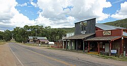
The community came into being around placer gold mining in the 1860s, although the source of the nuggets remained elusive. [3] In 1879, a prospector, miner, and assayer named Jacob Hess discovered silver in Ohio Creek, until then known as Gold Creek. Hess moved his camp to Ohio Creek and named his settlement Eagle City, [3] and officially became its first settler. In 1881, Ohio City was surveyed and platted. The following year, the Denver, South Park and Pacific Railroad was built through the town. After the collapse of the silver market in 1893 the community dwindled in population, [3] and by 1898, Ohio City was nearly deserted. [4]

However, the source of the first gold nuggets, having been discovered in 1896, prompted the multiple lucrative excavations including the Willow Creek Mine, which still yields feldspar, quartz, muscovite mica, graphic granite, and flakes of salvageable gold. [3] Opportunity Mine (GPS N38 30.676 / W106 39.995) is also a popular source for blue beryl, cleavelandite, black tourmaline, and pink lepidolite. [3]

Mines

In 1898, the Cortland Mine in McIntyre Gulch was the only mine operating in the district. Three Harvard University students, the Carter brothers, surveyed land during the summers at the turn of the century. One brother, Carroll M. Carter, organized the Carter Mining Company.

Around the same time, E. M. Lamont organized the Raymond Consolidated Mines Company which mined locally.

From 1908-1912, the Colorado Smelting and Mining Company, headed by A. E. Reynolds, mined the Sacramento mine and the Silver Islet mine. [5]

Geography

Ohio City is located at 38°34′04″N106°34′02″W / 38.56778°N 106.56722°W / 38.56778; -106.56722 (38.567764,-106.567211).

Climate

Climate type is dominated by the winter season, a long, bitterly cold period with short, clear days, relatively little precipitation mostly in the form of snow, and low humidity. The Köppen Climate Classification sub-type for this climate is "Dfc" (Continental Subarctic Climate). [6]

Climate data for Ohio City, Colorado
MonthJanFebMarAprMayJunJulAugSepOctNovDecYear
Average high °C (°F)−3
(26)
−1
(31)
6
(42)
13
(56)
19
(66)
24
(76)
27
(81)
26
(79)
22
(72)
16
(61)
7
(45)
−1
(30)
13
(55)
Average low °C (°F)−22
(−7)
−19
(−2)
−12
(11)
−6
(22)
−2
(29)
2
(36)
6
(43)
5
(41)
0
(32)
−6
(22)
−12
(10)
−19
(−3)
−7
(19)
Average precipitation mm (inches)20
(0.8)
20
(0.8)
18
(0.7)
18
(0.7)
20
(0.8)
18
(0.7)
38
(1.5)
36
(1.4)
25
(1)
18
(0.7)
15
(0.6)
20
(0.8)
260
(10.3)
Source: Weatherbase [7]

See also

Flag of Colorado.svg  Coloradoportal

Related Research Articles

<span class="mw-page-title-main">Pike's Peak Gold Rush</span> Nineteenth-century gold-prospecting frenzy in Colorado, US

The Pike's Peak Gold Rush was the boom in gold prospecting and mining in the Pike's Peak Country of western Kansas Territory and southwestern Nebraska Territory of the United States that began in July 1858 and lasted until roughly the creation of the Colorado Territory on February 28, 1861. An estimated 100,000 gold seekers took part in one of the greatest gold rushes in North American history.

<span class="mw-page-title-main">Idaho Springs, Colorado</span> City in Colorado, United States

The City of Idaho Springs is the statutory city that is the most populous municipality in Clear Creek County, Colorado, United States. Idaho Springs is a part of the Denver–Aurora–Lakewood, CO Metropolitan Statistical Area. As of the 2020 census it had a population of 1,782. Idaho Springs is located in Clear Creek Canyon, in the mountains upstream from Golden, some 30 miles (50 km) west of Denver.

<span class="mw-page-title-main">Eldora, Colorado</span> Census Designated Place in Colorado, United States

Eldora, previously known as "Eldorado" then "El-Dora", then Eldora or Camp Eldorado, and still called Happy Valley, is an unincorporated community and a census-designated place (CDP) located in and governed by Boulder County, Colorado, United States. The CDP is a part of the Boulder, CO Metropolitan Statistical Area. The population of the Eldora CDP was 140 at the United States Census 2020. The Nederland post office serves the area.

<span class="mw-page-title-main">Georgetown, Colorado</span> Town in Colorado, United States

Georgetown is the territorial charter municipality that is the county seat of Clear Creek County, Colorado, United States. The town population was 1,118 at the 2020 United States Census. The former silver mining camp along Clear Creek in the Front Range of the Rocky Mountains was established in 1859 during the Pike's Peak Gold Rush. The federally designated Georgetown-Silver Plume Historic District comprises Georgetown, the neighboring town of Silver Plume, and the Georgetown Loop Historic Mining & Railroad Park between the two towns. The Georgetown Post Office has the ZIP code 80444.

<span class="mw-page-title-main">Silver Plume, Colorado</span> Town in Colorado, United States

Silver Plume is a Statutory Town located in Clear Creek County, Colorado, United States. Silver Plume is a former silver mining camp along Clear Creek in the Front Range of the Rocky Mountains. The federally designated Georgetown-Silver Plume Historic District comprises Silver Plume, the neighboring town of Georgetown, and the Georgetown Loop Historic Mining & Railroad Park between the two towns.

<span class="mw-page-title-main">Gypsum, Colorado</span> Town in Colorado, United States

The Town of Gypsum is the home rule municipality that is the most populous municipality in Eagle County, Colorado, United States. The town population was 8,040 at the 2020 United States Census, a +24.13% increase since the 2010 United States Census. Gypsum is a part of the Edwards, CO Micropolitan Statistical Area. Gypsum is the home of an American Gypsum drywall plant and mine.

<span class="mw-page-title-main">Victor, Colorado</span> City in Colorado, United States

The City of Victor is a Statutory City in Teller County, Colorado, United States. Gold was discovered in Victor in the late 19th century, an omen of the future of the town. With Cripple Creek, the mining district became the second largest gold mining district in the country and realized approximately $10 billion of mined gold in 2010 dollars. It reached its peak around the turn of the century when there were about 18,000 residents in the town. Depleted ore in mines, labor strife and the exodus of miners during World War I caused a steep decline in the city's economy, from which it has never recovered. The population was 379 at the 2020 census. There is a resumed mining effort on Battle Mountain.

<span class="mw-page-title-main">Rollinsville, Colorado</span> Census-designated place in Gilpin County, Colorado, United States

Rollinsville is a census-designated place (CDP) and post office in and governed by Gilpin County, Colorado, United States. The CDP is a part of the Denver–Aurora–Lakewood, CO Metropolitan Statistical Area. The Rollinsville post office has the ZIP Code 80474. At the United States Census 2020, the population of the Rollinsville CDP was 194.

<span class="mw-page-title-main">Placerville, Colorado</span> Census-designated place in San Miguel County, Colorado, United States

Placerville is a census-designated place (CDP) and post office in and governed by San Miguel County, Colorado, United States. The Placerville post office has the ZIP Code 81430. At the United States Census 2020, the population of the Placerville CDP was 362.

<span class="mw-page-title-main">Granite, Colorado</span> Unincorporated community in Colorado, United States

Granite is an unincorporated community with a U.S. Post Office in Chaffee County, Colorado, United States. The zip code of Granite is 81228. According to the 2010 census, the population is 116.

<span class="mw-page-title-main">Parlin, Colorado</span> Unincorporated community in Colorado, United States

Parlin is an unincorporated community and a U.S. Post Office in Gunnison County, Colorado, United States. The Parlin Post Office has the ZIP Code 81239.

<span class="mw-page-title-main">Sargents, Colorado</span> Unincorporated community in Saguache County, Colorado, United States

Sargents is an unincorporated community and a U.S. Post Office in Saguache County, Colorado, United States. The Sargents Post Office has the ZIP code 81248.

<span class="mw-page-title-main">Caribou, Colorado</span>

Caribou is a former silver-mining town, now a ghost town near Nederland in Boulder County, Colorado, United States. It was named after the Caribou silver mine nearby. The Caribou Ranch recording studio is several miles away, on the road from Nederland up to Caribou.

Gold mining in Colorado, a state of the United States, has been an industry since 1858. It also played a key role in the establishment of the state of Colorado.

Silver mining in Colorado has taken place since the 1860s. In the past, Colorado called itself the Silver State.

<span class="mw-page-title-main">Henson, Colorado</span> Ghost town in Hindale County, Colorado, United States

Henson is a ghost town in Hinsdale County, Colorado, United States. Its elevation is 9,235 feet (2,815 m). Henson's name has historically been spelled several different ways, including Hansen, Hanson, Hensen, and Honsen; the Board on Geographic Names officially supported the current spelling in 1896. Henson was named for Henson Creek, which was named for a pioneer settler.

<span class="mw-page-title-main">Mary Murphy Mine</span>

The Mary Murphy Mine was the principal gold mine of the Chalk Creek mining district of Chaffee County, Colorado, United States, near St. Elmo, Colorado. The Mary Murphy Mine operated continuously from 1870 to 1925, and produced 220 thousand ounces of gold, worth $4.4 million then, plus considerable silver, lead, and zinc. There were two aerial tramways connecting the mine to Romley, Colorado, and the Denver, South Park and Pacific Railroad.

<span class="mw-page-title-main">Crisman, Colorado</span> Census Designated Place in Colorado, United States

Crisman is an unincorporated community and a census-designated place (CDP) located in and governed by Boulder County, Colorado, United States. The CDP is a part of the Boulder, CO Metropolitan Statistical Area. The population of the Crisman CDP was 179 at the United States Census 2020. The Boulder post office serves the area.

<span class="mw-page-title-main">Timeline of mining in Colorado</span>

Colorado mining history is a chronology of precious metal mining, fuel extraction, building material quarrying, and rare earth mining.

In the mid-19th century, Colorado Springs was a center of mining industry activity. Coal was mined in 50 mines in the area and towns, now annexed to Colorado Springs, were established to support residents of the coal mining industry.

References

  1. 1 2 "US Board on Geographic Names". United States Geological Survey. October 25, 2007. Retrieved January 31, 2008.
  2. 1 2 "ZIP Code Lookup". United States Postal Service. January 2, 2007. Archived from the original (JavaScript/HTML) on December 14, 2006. Retrieved January 2, 2007.
  3. 1 2 3 4 5 Kappele, William; Warren, Gary (2017). Rockhounding Colorado. Rowman & Littlefield. pp. 216–217. ISBN   9781493017393.
  4. Crawford, R. (1916). Colorado Geological Survey: Boulder: Bulletin 10: Geology and Ore Deposits of the Gold Brick District: Colorado. Denver: Eames Brothers, State Printers. p. 12.
  5. Crawford, R. (1916). Colorado Geological Survey: Boulder: Bulletin 10: Geology and Ore Deposits of the Gold Brick District: Colorado. Denver: Eames Brothers, State Printers. pp. 12–13.
  6. Climate Summary for Ohio City, Colorado
  7. "Weatherbase.com". Weatherbase. 2013. Retrieved on August 3, 2013.

Commons-logo.svg Media related to Ohio City, Colorado, at Wikimedia Commons