The Siuslaw River Bridge is a bascule bridge that spans the Siuslaw River on U.S. Route 101 in Florence, Oregon. It was designed by Conde McCullough, built by the Mercer-Fraser Company of Eureka, California, and funded by the Federal Emergency Administration of Public Works. It opened in 1936.

Dexter is an unincorporated community in Lane County, Oregon, United States. It is located near Dexter Reservoir, a.k.a. Dexter Lake, a reservoir of the Middle Fork Willamette River along Oregon Route 58.

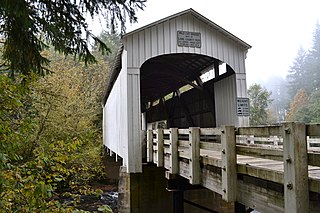
The Goodpasture Bridge spans the McKenzie River near the community of Vida in Lane County, Oregon, United States. It is the second longest covered bridge and one of the most photographed covered bridges in the state. The Goodpasture Bridge is listed on the National Register of Historic Places.
Wildcat Creek Bridge is a covered bridge built in 1925 at Austa, near Walton, in the U.S. state of Oregon. It uses Howe truss engineering and was listed on the National Register of Historic Places in 1979. The 75-foot (23 m) bridge carries Austa Road over Wildcat Creek near its confluence with the Siuslaw River.

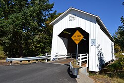
Stewart Bridge is a Howe truss covered bridge built in 1930 near Walden, Oregon, United States, in Lane County. It was listed on the National Register of Historic Places in 1979. It is 60 feet (18 m) long and crosses Mosby Creek, a tributary of the Row River.

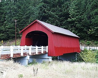
Unity Bridge is an historic 90-foot (27 m) long covered bridge over Fall Creek at Unity near Lowell in Lane County, Oregon, United States. Also known as Unity Covered Bridge and Unity Creek Bridge, it was built in 1936 at a cost $4,400 by Lane County using the Howe truss system. Its east side features a full-length window with its own roof so that drivers can see oncoming cars.

Hayden Bridge, a Howe truss structure, spans the Alsea River about 2 miles (3 km) west of Alsea, Oregon, United States. Constructed in 1918, the 91-foot (28 m) span is one of only seven remaining covered bridges in Oregon that were built before 1920. Similar spans such as the Mill Creek Bridge crossed the Alsea or one of its tributaries in the same vicinity, but only the Hayden Bridge has survived. It was added to the National Register of Historic Places in 1979.

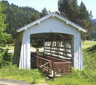
The Mosby Creek Bridge, also called the Layng Bridge, is a historic Howe truss covered bridge located near Cottage Grove, Oregon, United States. The bridge crosses Mosby Creek and was constructed in 1920, making it the oldest covered bridge in Lane County.
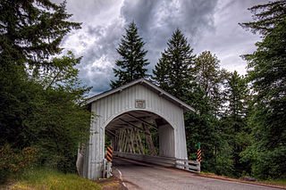
The Pengra Bridge is a covered bridge near Jasper in the U.S. state of Oregon. The 120-foot (37 m) Howe truss structure carries Place Road over Fall Creek in Lane County. It replaced an earlier bridge, built in 1904, that crossed the creek a few feet further upstream.

The Lake Creek Bridge also known as the Nelson Mountain Bridge, near Greenleaf, in the U.S. state of Oregon, is listed on the National Register of Historic Places. The 105-foot (32 m) covered bridge, built in 1928, carries Nelson Mountain Road over Lake Creek in Lane County.

The Coyote Creek Bridge near Crow, Oregon, United States, is listed on the National Register of Historic Places. The 60-foot (18 m) Howe truss structure, built in 1922, carries Battle Creek Road over Coyote Creek. The bridge is a site for hikes and other outdoor events during spring and summer.
The Deadwood Creek Bridge is a covered bridge in western Lane County in the U.S. state of Oregon. Built in 1932, the 105-foot (32 m) Howe truss structure carries Deadwood Loop Road over Deadwood Creek. The crossing lies upstream of the rural community of Deadwood in the Siuslaw National Forest of the Central Oregon Coast Range. The bridge was added to the National Register of Historic Places in 1979.

The Wendling Bridge is a covered bridge in Lane County in the U.S. state of Oregon. The 60-foot (18 m) Howe truss structure carries Wendling Road over Mill Creek in the unincorporated community of Wendling. Built in 1938, the bridge was added to the National Register of Historic Places in 1979.

The Sheely Bridge, originally known as the Carbondale Bridge, carries pedestrian traffic across the Roaring Fork River at Mill Street Park in Aspen, Colorado, United States. It is a short steel truss bridge originally located downstream in Carbondale and later moved to its present location.
Thomas Creek is a stream, about 35 miles (56 km) long, in Linn County in the U.S. state of Oregon. Beginning in Willamette National Forest on the western slopes of the Cascade Range, the creek flows generally west through Santiam State Forest and farmland to meet the South Santiam River west of Scio.

The Horse Creek Bridge was a covered bridge near the unincorporated community of McKenzie Bridge in Lane County in the U.S. state of Oregon. Built in 1930, the structure, 105 feet (32 m) long, carried Horse Creek Road over Horse Creek. The creek is a tributary of the McKenzie River.
The Fisher School Bridge is a covered bridge in Lincoln County in the U.S. state of Oregon. The 72-foot (22 m) Howe truss structure crosses a stream called Five Rivers near the rural community of Fisher in the Central Oregon Coast Range. Closed to vehicles, it is a pedestrian bridge.
Sandy Creek Bridge is a covered bridge spanning Sandy Creek near the community of Remote in southwestern Oregon in the United States. The bridge crosses the creek near its mouth on the Middle Fork Coquille River in Coos County.
The Brumbaugh Bridge was a covered bridge in Lane County in the U.S. state of Oregon. Built in 1948, the structure originally carried Row River Road over Mosby Creek near Cottage Grove. It was added to the National Register of Historic Places in 1979 and was subsequently delisted.

Lost Creek is a tributary of the Middle Fork Willamette River in the U.S. state of Oregon. It begins in the Cascade Range foothills between Dorena Lake and Lookout Point Lake and flows generally north to meet the river downstream of Lowell. Along the way, it passes by the rural community of Dexter, then under Oregon Route 58, and through part of Elijah Bristow State Park. Named tributaries of Lost Creek from source to mouth are Guiley, Gossage, Carr, Middle, Anthony, and Wagner creeks.