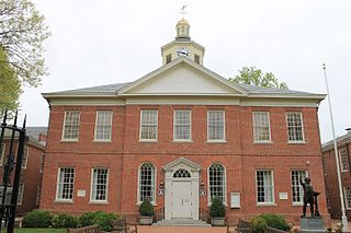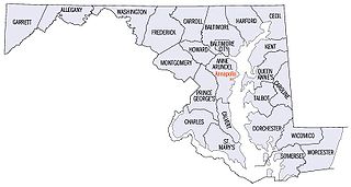
There are more than 1,500 properties and districts listed on the National Register of Historic Places in the U.S. State of Maryland. Each of the state's 23 counties and its one county-equivalent has at least 20 listings on the National Register.

The Modoc Rock Shelter is a rock cliff at the edge of the Mississippi River Valley that was undercut by Ice Age floods. This site is significant for its archaeological evidence of human habitation during the Archaic period in the Eastern United States. It is located on the northeastern side of County Road 7 southeast of Prairie du Rocher in Randolph County, Illinois, United States. It was declared a National Historic Landmark in 1961.

Oxon Cove Park and Oxon Cove Farm is a national historic district that includes a living farm museum operated by the National Park Service, and located at Oxon Hill, Prince George's County, Maryland. It is part of National Capital Parks-East. It was listed on the National Register of Historic Places in 2003.

The Thunderbird Archaeological District, near Limeton, Virginia, is archaeological district described as consisting of "three sites--Thunderbird Site, the Fifty Site, and the Fifty Bog--which provide a stratified cultural sequence spanning Paleo-Indian cultures through the end of Early Archaic times with scattered evidence of later occupation."
The Fort Thompson Mounds are a complex of archaeological sites in Buffalo County, South Dakota, near Fort Thompson and within the Crow Creek Reservation. Declared a National Historic Landmark in 1964, the mound complex extends for a distance of about 6 miles (9.7 km) along the Missouri River, and is one of the largest known complex of burial mounds in the Plains region north of Kansas.

The Green Hill Site is a prehistoric archaeological site in Canton, Massachusetts. It is located near the Neponset River, extending upland for a distance of about 500 feet (150 m) up to the crest of Green Hill, an elevation of about 110 feet (34 m). This area has been repeatedly excavated since the 1960s. The site encompasses a Middle to Late Archaic period encampment, where Neville style projectile points, gouges for woodworking, and a stone-working worksite have been found.
Arundel Cove Archaeological Site is an archaeological site near Baltimore in Anne Arundel County, Maryland. It is situated on the south shore of Arundel Cove, a tributary of Curtis Creek which drains into the Patapsco River. The site was discovered during routine shovel test pitting of the U.S. Coast Guard Yard at Curtis Bay in 1981. The test pits revealed that the site is small in size, extending only 20 feet north-south by 15 feet east-west. It represents the remains of a prehistoric summer camp which apparently was not repeatedly occupied. It contains a prehistoric period storage pits, with evidence of the use of galium and wild black cherry.
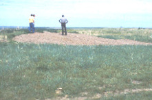
The Old Colony Cove Site is an archaeological site near Rose Haven in Anne Arundel County, Maryland. The site consists of a shell midden and is 2,000 feet long by 300 feet wide.
Buckingham Archeological Site is an archaeological site near Berlin in Worcester County, Maryland. It is one of the few known Woodland period village sites in the coastal marsh areas of the Atlantic Coast section of Maryland. The site falls within the general vicinity of an Assateague Indian town. It is located four miles east of the Sandy Point Site, both including the southernmost reported occurrence of Townsend Series ceramics on the coastal section of the Eastern Shore.
Willin Village Archeological Site is an archaeological site near Eldorado in Dorchester County, Maryland. The Sussex Society of Archeology and History extensively excavated this site between 1951 and 1953. They identified grooved axes and stemmed points indicating use by Archaic peoples. It was possibly the site of a village during the Late Woodland period.
Brinsfield I Site, or Brinsfield I Prehistoric Village Site, is an archaeological site near Cambridge in Dorchester County, Maryland. The site was first identified in 1955 by Perry S. Flegel of the Sussex Society of Archaeology & History. It is a late prehistoric archaeological site characterized by shell-tempered pottery and triangular projectile points. The site may provide evidence of prehistoric life on the eastern shore of Maryland during the Late Woodland period, c. 900–1500.
Shoemaker III Village Site is an archaeological site near Emmitsburg, in the extreme northern section of Frederick County, Maryland. Pottery fragments, projectile points, and other artifacts found at the site date it to 900-1300.
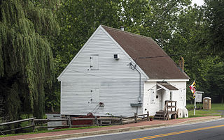
The Wye Mill is the oldest continuously operated grist mill in the United States, located at Wye Mills, Queen Anne's County and Talbot County, Maryland, United States. It is the earliest industrial site on the Eastern Shore in continuous use; dating to the late 17th century. It is a wood-frame, water-powered grist mill, with a 19th-century 26 HP 10-foot-diameter (3.0 m) Fitz steel overshot wheel. The mill retains nearly all of its late-18th-century equipment. The Wye Mill was one of the first grist mills to be automated with the Oliver Evans process, which is still in use today.

The Doncaster Town Site is an archeological site near Easton, Talbot County, Maryland. The site is located on one of the earliest land grants in Talbot County, surveyed on October 18, 1658. It is the location of the first Roman Catholic Church erected on the Eastern Shore of Maryland. The town was erected in 1684 and was one of the first planned towns in Maryland. At its peak Doncaster would have contained inns, a chapel, warehouses, a ferry, stores, stocks and a whipping post, a public square, and a number of residences. Archeological deposits were recorded in 1961.

The Sommerheim Park Archaeological District includes a group of six archaeological sites west of Erie, Pennsylvania in the United States. The sites are in Sommerheim Park, one of the few undeveloped areas of the Lake Erie shoreline, in Millcreek Township. This district has been listed on the National Register of Historic Places. This is one of the leading archaeological sites in the Erie area and along the southern shoreline of Lake Erie, due to the amount of artifacts and the lack of disturbance on the site.

The LoDaisKa Site is a prominent archaeological site in the U.S. state of Colorado, located within a rockshelter near Morrison. The rockshelter was first inhabited by people of the Archaic through the Middle Ceramic period, generally spanning 3000 BC to 1000 AD.
The Cooper Site is an archaeological site in Lyme, Connecticut. On a terrace of the Connecticut River near Hamburg Cove, the site has yielded evidence of Middle to Late Woodland occupation. The Late Woodland component includes evidence interpreted as the site of a wigwam, with a large number of stone chips consistent with the development of stone tools at the site. The Middle Woodland component is interpreted as a series of small camps whose occupation was relatively brief. Finds at the site have been dated as far back as c. 500 CE, and include narrow-stemmed projectile points, most of which were made from local quartz, but also from more distant chert and hornfels, some which is from quarries as far off as New Jersey. Pottery finds include fragments with dentate stamping.

The Duffy Site is a substantial archaeological site along the Wabash River in the southeastern part of the U.S. state of Illinois. Located near the village of New Haven in Gallatin County, it is the type site for the Duffy Complex, a group of similar sites on the Illinois side of the Wabash near its confluence with the Ohio River. Duffy is distinctive largely because of its pottery: the site's inhabitants typically produced ceramics of various thicknesses and comparatively few decorative elements, tempered with grog. What decorations exist are typically limited to one or two rows of simple lines or bars that have been incised or stamped on the side of the piece of pottery. Projectile points found at the site are small triangular "Mounds Stemless" points, and the inhabitants produced celts of a vaguely rectangular shape. The site is believed to have been inhabited circa AD 1000.

The Scarborough House Archaeological Site in Accomack County, Virginia, is believed to be the location of the estate house of Edmund Scarborough, the Eastern Shore's largest landowner in the 17th century. Called Occohannock House for its location on the creek of the same name, the site is now buried in a silted-over cove called Scarborough Gut. Virginia state archaeologists have mapped the extent and integrity of the site.