Pedricktown, New Jersey

Last updated

Pedricktown, New Jersey
Location map of Salem County, New Jersey.svg
Red pog.svg
Pedricktown
Location in Salem County
USA New Jersey relief location map.svg
Red pog.svg
Pedricktown
Location in New Jersey
Usa edcp relief location map.png
Red pog.svg
Pedricktown
Location in the United States
Coordinates: 39°45′59″N75°24′27″W / 39.76643°N 75.407591°W / 39.76643; -75.407591 [1] [2]
Country Flag of the United States.svg  United States
State Flag of New Jersey.svg  New Jersey
County Salem
Township Oldmans
Area
[3]
  Total1.82 sq mi (4.73 km2)
  Land1.74 sq mi (4.51 km2)
  Water0.08 sq mi (0.22 km2)  0.21%
Elevation
[4]
10 ft (3 m)
Population
 (2020) [5]
  Total487
  Density279.56/sq mi (107.97/km2)
Time zone UTC−05:00 (Eastern (EST))
  Summer (DST) UTC−04:00 (Eastern (EDT))
ZIP Code
08067 [6]
Area code 856
FIPS code 34-57360 [7] [8]
GNIS feature ID02584016 [9]

Pedricktown is an unincorporated community and census-designated place (CDP) [10] located within Oldmans Township, in Salem County, in the U.S. state of New Jersey. [11] [12] [13] [14] As of the 2010 United States Census, the CDP's population was 524. [15] The area is served as United States Postal Service ZIP Code 08067.

Contents

History

In June 1675 in Shadwell, England, Roger Pedrick and his wife Rebekah Holeman Pedrick, members of the Society of Friends, purchased 1,000 acres (400 ha) of land from John Fenwick, and shortly thereafter crossed the Atlantic to be in their new home. They originally settled in Chester, Pennsylvania, while their home was being built on their property on the other side of the Delaware. The minutes of the "Men's and Women's Friends Meeting" (a Quaker group) refer to the area as "Pedricks Neck" in the 1720s and the birth records of many of Roger's and Rebekah's descendants list their birthplace as "Pedricksburg." [16]

Geography

According to the United States Census Bureau, Pedricktown had a total area of 0.905 square miles (2.345 km2), including 0.903 square miles (2.340 km2) of land and 0.002 square miles (0.005 km2) of water (0.21%). [1] [2]

Demographics

As of the 2020 United States census, the population was 487. [5]

Historical population
CensusPop.Note
2020 487
U.S. Decennial Census [17]
2020 [5]

2010 census

The 2010 United States census counted 524 people, 197 households, and 147 families in the CDP. The population density was 580.0 per square mile (223.9/km2). There were 220 housing units at an average density of 243.5 per square mile (94.0/km2). The racial makeup was 91.79% (481) White, 2.67% (14) Black or African American, 0.00% (0) Native American, 0.19% (1) Asian, 0.00% (0) Pacific Islander, 4.58% (24) from other races, and 0.76% (4) from two or more races. Hispanic or Latino of any race were 9.92% (52) of the population. [15]

Of the 197 households, 36.0% had children under the age of 18; 53.8% were married couples living together; 13.2% had a female householder with no husband present and 25.4% were non-families. Of all households, 20.3% were made up of individuals and 5.1% had someone living alone who was 65 years of age or older. The average household size was 2.66 and the average family size was 3.04. [15]

26.9% of the population were under the age of 18, 6.7% from 18 to 24, 28.4% from 25 to 44, 27.5% from 45 to 64, and 10.5% who were 65 years of age or older. The median age was 36.0 years. For every 100 females, the population had 94.8 males. For every 100 females ages 18 and older there were 100.5 males. [15]

Economy

Goya Foods has its South Jersey division in Pedricktown. [18]

Winery

Transportation

Pedricktown is accessible at Exit 7 of Interstate 295 via County Route 643.

The Spitfire Aerodrome ( FAA LID : 7N7) is a small municipal airport located in Pedricktown. [19]

Related Research Articles

<span class="mw-page-title-main">Moorestown-Lenola, New Jersey</span> Populated place in Burlington County, New Jersey, US

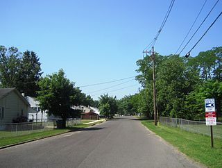
Moorestown-Lenola is an unincorporated community and census-designated place (CDP) located within Moorestown Township in Burlington County, in the U.S. state of New Jersey. As of the 2010 United States Census, the CDP's population was 14,217.

<span class="mw-page-title-main">Pemberton Heights, New Jersey</span> Populated place in Burlington County, New Jersey, US

Pemberton Heights is an unincorporated community and census-designated place (CDP) located within Pemberton Township, in Burlington County, in the U.S. state of New Jersey. As of the 2010 United States Census, the CDP's population was 2,423.

<span class="mw-page-title-main">Ramblewood, New Jersey</span> Populated place in Burlington County, New Jersey, US

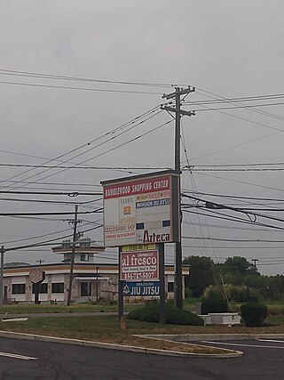
Ramblewood is an unincorporated community and census-designated place (CDP) located within Mount Laurel in Burlington County, in the U.S. state of New Jersey. As of the 2010 United States Census, the CDP's population was 5,907.

<span class="mw-page-title-main">Fairton, New Jersey</span> Populated place in Cumberland County, New Jersey, US

Fairton is an unincorporated community and census-designated place (CDP) located within Fairfield Township, in Cumberland County, in the U.S. state of New Jersey. It is part of the Vineland-Millville-Bridgeton Primary Metropolitan Statistical Area for statistical purposes. As of the 2010 United States Census, the CDP's population was 1,264.

<span class="mw-page-title-main">Concordia, New Jersey</span> Populated place in Middlesex County, New Jersey, US

Concordia is an unincorporated community and census-designated place (CDP) located within Monroe Township, in Middlesex County, in the U.S. state of New Jersey. The CDP is oriented around the age restricted gated community of Concordia. As of the 2010 United States Census, the CDP's population was 3,092.

<span class="mw-page-title-main">Whittingham, New Jersey</span> Populated place in Middlesex County, New Jersey, US

Whittingham, also known as Greenbriar at Whittingham, is an unincorporated community and census-designated place (CDP) located within Monroe Township, in Middlesex County, in the U.S. state of New Jersey. As of the 2010 United States Census, the CDP's population was 2,476. The area is focused around the age-restricted gated community of Whittingham.

<span class="mw-page-title-main">Yorketown, New Jersey</span> Populated place in Monmouth County, New Jersey, US

Yorketown is an unincorporated community and census-designated place (CDP) within Manalapan Township, in Monmouth County, in the U.S. state of New Jersey. At the 2020 census, the CDP's population was 6,739.

<span class="mw-page-title-main">Leisure Village, New Jersey</span> Populated place in Ocean County, New Jersey, US

Leisure Village is an unincorporated community and census-designated place (CDP) located within Lakewood Township, in Ocean County, in the U.S. state of New Jersey. As of the 2010 United States Census, the CDP's population was 4,400. The sprawling active adult community is also locally known as "Original" Leisure Village because it was the first of three neighboring active adult communities bearing similar names. Leisure Village East, and Leisure Village West are the other two communities nearby. Original Leisure Village (OLV) is also referred to by the moniker "The Village of Seven Lakes."

<span class="mw-page-title-main">Vista Center, New Jersey</span> Populated place in Ocean County, New Jersey, US

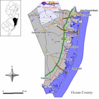
Vista Center is an unincorporated community and census-designated place (CDP) located within Jackson Township in Ocean County, in the U.S. state of New Jersey. As of the 2010 United States Census, the CDP's population was 3,689.

<span class="mw-page-title-main">Olivet, New Jersey</span> Populated place in Salem County, New Jersey, US

Olivet is an unincorporated community and census-designated place (CDP) located within Pittsgrove Township, in Salem County, in the U.S. state of New Jersey. As of the 2010 United States Census, the CDP's population was 1,408.

<span class="mw-page-title-main">Vernon Valley, New Jersey</span> Populated place in Sussex County, New Jersey, US

Vernon Valley is an unincorporated community and census-designated place (CDP) located in Vernon Township, in Sussex County, in the U.S. state of New Jersey. As of the 2010 United States Census, the CDP's population was 1,626.

<span class="mw-page-title-main">Lakewood (CDP), New Jersey</span> Populated place in Ocean County, New Jersey, US

Lakewood is an unincorporated community and census-designated place (CDP) located within Lakewood Township, in Ocean County, in the U.S. state of New Jersey. As of the 2010 United States Census, the CDP's population was 53,805.

<span class="mw-page-title-main">Alloway (CDP), New Jersey</span> Populated place in Salem County, New Jersey, US

Alloway is an unincorporated community and census-designated place (CDP) located within Alloway Township, in Salem County, in the U.S. state of New Jersey. As of the 2010 United States Census, the CDP's population was 1,402.

<span class="mw-page-title-main">Pennsville (CDP), New Jersey</span> Populated place in Salem County, New Jersey, US

Pennsville is an unincorporated community and census-designated place (CDP) located within Pennsville Township, in Salem County, in the U.S. state of New Jersey. As of the 2010 United States Census, the CDP's population was 11,888.

<span class="mw-page-title-main">Hancock's Bridge, New Jersey</span> Populated place in Salem County, New Jersey, US

Hancock's Bridge is an unincorporated community and census-designated place (CDP) located within Lower Alloways Creek Township, in Salem County, in the U.S. state of New Jersey. As of the 2010 United States Census, the CDP's population was 254. The area is served as United States Postal Service ZIP Code 08038.

Clyde is an unincorporated community and census-designated place (CDP) located in Franklin Township, in Somerset County, in the U.S. state of New Jersey. It was a station stop on the Penna RR's Millstone Branch. As of the 2010 United States Census, the CDP's population was 213.

Franklin Center is an unincorporated community and census-designated place (CDP) located in Franklin Township, in Somerset County, in the U.S. state of New Jersey. As of the 2010 United States Census, the CDP's population was 4,460.

Broadway is an unincorporated community and census-designated place (CDP) located within Franklin Township, in Warren County, in the U.S. state of New Jersey, that was created as part of the 2010 United States Census. As of the 2010 Census, the CDP's population was 244.

<span class="mw-page-title-main">Quinton (CDP), New Jersey</span> Populated place in Salem County, New Jersey, US

Quinton is an unincorporated community and census-designated place (CDP) located within Quinton Township, in Salem County, in the U.S. state of New Jersey. As of the 2010 United States Census, the CDP's population was 1,402.

Vernon Center is an unincorporated community and census-designated place (CDP) located in Vernon Township, in Sussex County, in the U.S. state of New Jersey. As of the 2010 United States Census, the CDP's population was 1,713.

References

  1. 1 2 Gazetteer of New Jersey Places, United States Census Bureau. Accessed July 21, 2016.
  2. 1 2 US Gazetteer files: 2010, 2000, and 1990, United States Census Bureau. Accessed September 4, 2014.
  3. "ArcGIS REST Services Directory". United States Census Bureau. Retrieved October 11, 2022.
  4. U.S. Geological Survey Geographic Names Information System: Pedricktown Census Designated Place, Geographic Names Information System. Accessed February 9, 2013.
  5. 1 2 3 Census Data Explorer: Pedricktown CDP, New Jersey, United States Census Bureau. Accessed June 15, 2023.
  6. Look Up a ZIP Code for Pedricktown, NJ, United States Postal Service. Accessed September 27, 2012.
  7. U.S. Census website, United States Census Bureau. Accessed September 4, 2014.
  8. Geographic Codes Lookup for New Jersey, Missouri Census Data Center. Accessed June 9, 2023.
  9. US Board on Geographic Names, United States Geological Survey. Accessed September 4, 2014.
  10. State of New Jersey Census Designated Places - BVP20 - Data as of January 1, 2020, United States Census Bureau. Accessed December 1, 2022.
  11. GCT-PH1 - Population, Housing Units, Area, and Density: 2010 - County -- County Subdivision and Place from the 2010 Census Summary File 1 for Salem County, New Jersey Archived 2020-02-12 at archive.today , United States Census Bureau. Accessed February 9, 2013.
  12. 2006-2010 American Community Survey Geography for New Jersey, United States Census Bureau. Accessed February 9, 2013.
  13. New Jersey: 2010 - Population and Housing Unit Counts - 2010 Census of Population and Housing (CPH-2-32), United States Census Bureau, August 2012. Accessed February 9, 2013.
  14. Locality Search, State of New Jersey. Accessed April 19, 2015.
  15. 1 2 3 4 DP-1 - Profile of General Population and Housing Characteristics: 2010 Demographic Profile Data for Pedricktown CDP, New Jersey Archived 2020-02-12 at archive.today , United States Census Bureau. Accessed February 9, 2013.
  16. Shoemaker, Hubert B. (1938). A Genealogical and Biographical Record of the Pedrick Family of New Jersey 1675-1938. Philadelphia.{{cite book}}: CS1 maint: location missing publisher (link)
  17. Census of Population and Housing, United States Census Bureau. Accessed June 1, 2023.
  18. Contact Us. Goya Foods. Accessed March 26, 2016. "Goya Foods of South Jersey 1 Industrial Way Pedricktown, NJ 08067"
  19. Spitfire Aerodrome, New Jersey Department of Transportation. Accessed July 22, 2016.