Penambol Conservation Park

Last updated

Penambol Conservation Park
South Australia
IUCN category VI (protected area with sustainable use of natural resources)
Australia South Australia relief location map.png
Red pog.svg
Penambol Conservation Park
Nearest town or city Mount Gambier
Coordinates 37°58′10″S140°52′50″E / 37.9695°S 140.8806°E / -37.9695; 140.8806 Coordinates: 37°58′10″S140°52′50″E / 37.9695°S 140.8806°E / -37.9695; 140.8806
Established4 November 1993 (1993-11-04) [1]
Area1.8 km2 (0.7 sq mi) [2]
Managing authorities Department for Environment and Water
Website Penambol Conservation Park
FootnotesCoordinates [3]
Nearest town [4]
Managing authority [2]
See also Protected areas of South Australia

Penambol Conservation Park is a protected area in the Australian state of South Australia located in the state's south-east in the gazetted locality of Caroline about 22 kilometres (14 mi) south-east of the city centre in Mount Gambier. [4] [5]

Protected area location which receives protection because of its recognised natural, ecological or cultural landscape values

Protected areas or conservation areas are locations which receive protection because of their recognized natural, ecological or cultural values. There are several kinds of protected areas, which vary by level of protection depending on the enabling laws of each country or the regulations of the international organizations involved.

South Australia State of Australia

South Australia is a state in the southern central part of Australia. It covers some of the most arid parts of the country. With a total land area of 983,482 square kilometres (379,725 sq mi), it is the fourth-largest of Australia's states and territories by area, and fifth largest by population. It has a total of 1.7 million people, and its population is the second most highly centralised in Australia, after Western Australia, with more than 77 percent of South Australians living in the capital, Adelaide, or its environs. Other population centres in the state are relatively small; Mount Gambier, the second largest centre, has a population of 28,684.

Caroline, South Australia Suburb of District Council of Grant, South Australia

Caroline is a locality in the Australian state of South Australia located about 389 kilometres (242 mi) south-east of the state capital of Adelaide and about 12 kilometres (7.5 mi) north-west of the municipal seat of Mount Gambier adjoining the border with the state of Victoria.

Contents

The conservation park occupies land in sections 382, 383, 384 and 701 of the cadastral unit of the Hundred of Caroline which is located to the north of the Glenelg River Road. The land is sections 382, 383 and 384 are bounded by Cameron Road to the west, Honeysuckle Road to the north and Carba Road to the east while the land in section 701 is located on the north side of Honeysuckle Road at the intersection with Carba Road. [5] As of 1992, a fire water supply tank and a windmill were located in the “central section” (presumably section 383) while an airfield operated by the Department of Primary Industries and Resources South Australia was located in section 701. [4]

Lands administrative divisions of South Australia

The lands administrative divisions of South Australia are the cadastral units of counties and hundreds in South Australia. They are located only in the south-eastern part of the state, and do not cover the whole state. 49 counties have been proclaimed across the southern and southeastern areas of the state historically considered to be arable and thus in need of a cadastre. Within that area, a total of 540 hundreds have been proclaimed, although five were annulled in 1870, and, in some cases, the names reused elsewhere.

The land was “acquired for conservation purposes in 1984” and was constituted as the Penambol Conservation Park under the National Parks and Wildlife Act 1972 on 4 November 1993 with access permitted for the purpose of “entry, prospecting, exploration and mining” under the Mining Act 1971 and the Petroleum Act 1940. [4] [1] Its name is derived from the Booandik language word recorded by the missionary, Christina Smith, for “Stringybark Forest” and was approved for the conservation park's name in 1987 over the proposed name of Pond Flat Conservation Park. [5] As of July 2016, the conservation park covered an area of 1.8 square kilometres (0.69 sq mi). [2]

Bungandidj is a language of Australia, spoken by the Bungandidj people, Indigenous Australians who lived in an area which is now in south-eastern South Australia and in south-western Victoria. According to Christina Smith and her book on the Buandig people, the Bungandidj called their language drualat-ngolonung, or Booandik-ngolo.

Christina Smith (missionary) Christian lay missionary and educator

Christina Smith (1809-1893) was a teacher and Christian missionary who documented the lives, customs, legends, and language of the Buandig Indigenous Australians who live in south-eastern South Australia and western Victoria.

In 1992, the conservation park was described as being located on a “consolidated inland dune system” which contains the “three significant karst features” that located in the ‘central section”, the “south-east section” (presumably section 382) and section 701 which is described as “a large cenote (a collapsed doline), known locally as the Caroline Sinkhole.” [4] [5] It was described as supporting the following major vegetation associations: [4]

Karst Topography formed from the dissolution of soluble rocks

Karst is a topography formed from the dissolution of soluble rocks such as limestone, dolomite, and gypsum. It is characterized by underground drainage systems with sinkholes and caves. It has also been documented for more weathering-resistant rocks, such as quartzite, given the right conditions. Subterranean drainage may limit surface water, with few to no rivers or lakes. However, in regions where the dissolved bedrock is covered or confined by one or more superimposed non-soluble rock strata, distinctive karst features may occur only at subsurface levels and be totally missing above ground.

  1. An “open woodland” of messmate stringybark dominates most of the conservation park and supports an understorey including the following species - clover glycine, Derwent speedwell, golden-tip, hop wattle, ivy-leaved violet, rough bush-pea and tiger-orchid.
  2. The “central section” which cleared for agricultural purposes prior to 1984 is dominated by introduced grass species, although native species dominated by blackwood were “beginning to regenerate in this area.”

The conservation park was also reported in 1992 as having the following “locally significant fauna” within its boundaries - bush rat, common brushtail possum, common wombat, eastern grey kangaroo, red-necked wallaby, ring tailed possum, short-beaked echidna, yellow-bellied glider and the following bird species which were listed as being “rare” in South Australia in 1992 - gang-gang cockatoo and red-tailed black cockatoo. [4]

Bush rat species of mammal

The bush rat is a small Australian nocturnal animal. It is an omnivore and one of the most common indigenous species of rats on the continent, found in many heathland areas of Victoria and New South Wales.

Common brushtail possum semi-arboreal marsupial of the family Phalangeridae, native to Australia

The common brushtail possum is a nocturnal, semi-arboreal marsupial of the family Phalangeridae, native to Australia, and the second-largest of the possums.

Common wombat species of marsupial

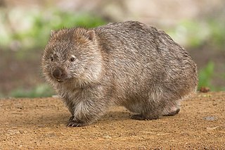
The common wombat, also known as the coarse-haired wombat or bare-nosed wombat, is a marsupial, one of three extant species of wombats and the only one in the genus Vombatus. The common wombat grows to an average of 98 cm (39 in) long and a weight of 26 kg (57 lb).

The conservation park is classified as an IUCN Category VI protected area. [3]

International Union for Conservation of Nature international organisation

The International Union for Conservation of Nature is an international organization working in the field of nature conservation and sustainable use of natural resources. It is involved in data gathering and analysis, research, field projects, advocacy, and education. IUCN's mission is to "influence, encourage and assist societies throughout the world to conserve nature and to ensure that any use of natural resources is equitable and ecologically sustainable".

See also

Related Research Articles

Hacks Lagoon Conservation Park Protected area in South Australia

Hacks Lagoon Conservation Park is a protected area in the Australian state of South Australia located in the locality of Bool Lagoon about 24 kilometres south of the municipal seat of Naracoorte.

Mount Magnificent Conservation Park Protected area in South Australia

Mount Magnificent Conservation Park is a protected area in the Australian state of South Australia located in the Mount Lofty Ranges about 58 kilometres south of the state capital of Adelaide. It is located within the gazetted locality of Mount Magnificent.

Grass Tree Conservation Park Protected area in South Australia

Grass Tree Conservation Park is a protected area in the Australian state of South Australia located in the state's Limestone Coast in the gazetted locality of Cadgee about 17 kilometres (11 mi) north of the town centre in Naracoorte.

Bangham Conservation Park Protected area in South Australia

Bangham Conservation Park is a protected area in the Australian state of South Australia located in the state's Limestone Coast in the gazetted locality of Bangham about 45 kilometres (28 mi) north-east of the town centre in Naracoorte.

Pine Hill Soak Conservation Park Protected area in South Australia

Pine Hill Soak Conservation Park is a protected area in the Australian state of South Australia located in the state's Limestone Coast in the gazetted locality of Bangham about 30 kilometres (19 mi) south of the town centre in Bordertown.

Telford Scrub Conservation Park Protected area in South Australia

Telford Scrub Conservation Park is a protected area in the Australian state of South Australia located in the state's Limestone Coast in the gazetted locality of Dismal Swamp about 14 kilometres (8.7 mi) north of the city centre in Mount Gambier.

Mary Seymour Conservation Park Protected area in South Australia

Mary Seymour Conservation Park is a protected area in the Australian state of South Australia located in the south-east of the state in the gazetted locality of Bool Lagoon about 25 kilometres (16 mi) south-west of the town centre of Naracoorte.

Gower Conservation Park Protected area in South Australia

Gower Conservation Park is a protected area located in the Australian state of South Australia in the locality of Tantanoola about 353 kilometres (219 mi) south-east of the state capital of Adelaide and about 25 kilometres (16 mi) north west of the regional city of Mount Gambier.

Furner Conservation Park Protected area in South Australia

Furner Conservation Park is a protected area located in the Australian state of South Australia in the locality of Furner about 310 kilometres (190 mi) south-east of the state capital of Adelaide and about 27 kilometres (17 mi) north west of the municipal seat of Millicent.

Calectasia Conservation Park Protected area in South Australia

Calectasia Conservation Park, formerly the Calectasia National Parks Reserve, is a protected area located in the Australian state of South Australia in the locality of Wattle Range about 320 kilometres (200 mi) south-east of the state capital of Adelaide and about 25 kilometres (16 mi) west of the town of Penola.

Glen Roy Conservation Park Protected area in South Australia

Glen Roy Conservation Park is a protected area located in the Australian state of South Australia in the locality of Glenroy about 323 kilometres (201 mi) south-east of the state capital of Adelaide and about 25 kilometres (16 mi) north of the town of Penola.

Penola Conservation Park Protected area in South Australia

Penola Conservation Park is a protected area located in the Australian state of South Australia in the locality of Monbulla about 329 kilometres (204 mi) south-east of the state capital of Adelaide and about 12 kilometres (7.5 mi) west of the town of Penola.

Nixon-Skinner Conservation Park Protected area in South Australia

Nixon-Skinner Conservation Park is a protected area located in the Australian state of South Australia in the locality of Myponga about 55 kilometres (34 mi) south of the state capital of Adelaide and about 3.5 kilometres (2.2 mi) south-west of the town of Myponga.

Mylor Conservation Park Protected area in South Australia

Mylor Conservation Park is a protected area located in the Australian state of South Australia in the suburb of Mylor in the Adelaide Hills state government region about 19 kilometres (12 mi) south-east of the state capital of Adelaide and about 1 kilometre (0.62 mi) north-east of the town of Mylor.

Pooginook Conservation Park Protected area in South Australia

Pooginook Conservation Park is a protected area located in the Australian state of South Australia in the locality of Pooginook about 166 kilometres (103 mi) north-east of the state capital of Adelaide and about 12 kilometres (7.5 mi) north-east of the town of Waikerie.

Geegeela Conservation Park Protected area in South Australia

Geegeela Conservation Park is a protected area in the Australian state of South Australia located in the state's south-east in the gazetted locality of Bangham about 277 kilometres (172 mi) north-west of the state capital of Adelaide and about 12 kilometres (7.5 mi) north-west of the town centre in Frances.

Padthaway Conservation Park Protected area in South Australia

Padthaway Conservation Park is a protected area in the Australian state of South Australia located in the state's south-east in the gazetted locality of Padthaway about 253 kilometres (157 mi) south-east of the state capital of Adelaide and about 2.5 kilometres (1.6 mi) north-east of the locality's town centre.

Jip Jip Conservation Park Protected area in South Australia

Jip Jip Conservation Park is a protected area in the Australian state of South Australia located in the state’s south-east in the gazetted locality of Marcollat about 223 kilometres (139 mi) south-east of the state capital of Adelaide and about 50 kilometres (31 mi) north-east of the municipal seat of Kingston SE.

Mount Monster Conservation Park Protected area in South Australia

Mount Monster Conservation Park is a protected area in the Australian state of South Australia located in the state’s south-east in the gazetted locality of Keith about 210 kilometres (130 mi) south-east of the state capital of Adelaide and about 12 kilometres (7.5 mi) south of the town centre in Keith.

Spring Mount Conservation Park Protected area in South Australia

Spring Mount Conservation Park, formerly the Spring Mount Wild-Life Reserve, is a protected area in the Australian state of South Australia located in the localities of Hindmarsh Valley and Inman Valley about 57 kilometres (35 mi) south of the state capital of Adelaide.

References

  1. 1 2 "NATIONAL PARKS AND WILDLIFE ACT 1972 PART III: CONSTITUTION OF NEW RESERVES AND ADDITION OF LAND TO EXISTING RESERVES WITH PRESERVATION OF EXISTING MINING RIGHTS" (PDF). The South Australian Government Gazette. Government of South Australia: 2174. 4 November 1993. Retrieved 13 April 2017.
  2. 1 2 3 "Protected Areas Information System - reserve list (as of 11 July 2016)" (PDF). Department of Environment Water and Natural Resources. 11 July 2016. Retrieved 14 July 2016.
  3. 1 2 "Terrestrial Protected Areas of South Australia (see 'DETAIL' tab)". CAPAD 2014. Australian Government, Department of the Environment (DoE). 2014. Retrieved 20 June 2016.
  4. 1 2 3 4 5 6 7 South Australia. National Parks and Wildlife Service. South East District; Sutherland, Andrea; South Australia. National Parks and Wildlife Service (1992), Small parks of the upper South East management plans, South East, South Australia (PDF), Dept. of Environment and Planning, pp. 26–28, ISBN   978-0-7308-2665-1
  5. 1 2 3 4 "Search result(s) for Penambol Conservation Park (Record No. SA0054290) with the following layers being selected - "Parcel labels", "Suburbs and Localities", "Hundreds", "Place names (gazetteer)" and "Road labels"". Property Location Browser. Government of South Australia. Retrieved 13 April 2017.